Relic point Vietnam
Việt Nam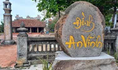
An Vinh Communal House
An Vinh communal house is one of the typical ancient communal houses on Ly Son island, carrying special value in terms of history, culture and sovereignty over Vietnam's islands and islands. The communal house was built around the 18th century, went through many upheavals of time, war and natural disasters but is still preserved, restored and preserved by generations of people. The communal house is located near Ly Son seaport, has a campus of about 2,000m², the communal house faces the mainland. The project has the architectural style of the Nguyen Dynasty, with a Tam-shaped structure with a lower, middle and upper communal house linked together. The four sacred and five blessings motifs are shown on the roof and architectural structures, conveying the desire for a peaceful and prosperous life of the island community. An Vinh communal house is also a place to worship ancestors and a community center for 13 families on Ly Son island. In particular, this is one of the important locations where the Commemoration Ceremony of Hoang Sa soldiers takes place in the third lunar month every year. The ceremony commemorates the soldiers who obeyed the royal court's orders and crossed the sea to Hoang Sa and Truong Sa to carry out their duties, contributing to protecting and affirming Vietnam's sovereignty over the sea and islands. Along with architectural values and traditional cultural activities, An Vinh Communal House is a place to preserve historical memories of the Ly Son community, expressing the ethic of "when drinking water, remember the source", patriotism and the sense of preserving sovereignty over the sea and islands. An Vinh Communal House has been classified as a National Monument, while the Hoang Sa Soldiers' Commemoration Ceremony has been recognized as a National Intangible Cultural Heritage. Today, the relic is a meaningful destination for tourists coming to Ly Son, contributing to introducing unique cultural values and the tradition of protecting the sovereignty of the sea and islands of the Vietnamese people. Source: Quang Ngai Newspaper and Radio and Television
Quang Ngai
205 view
Rating : National monument
Thien An Mountain
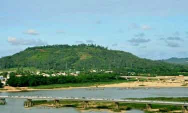
Thien An Mountain, also known as Ho Mountain, is a historical-cultural relic and the leading sacred symbol of Quang Ngai province. Located on the left bank of the Tra Khuc River, this unique isosceles trapezoid-shaped mountain is like a precious seal of heaven stamped on the riverbed, creating the famous "Nien An Thien Ha" mountain position in poetry. Over the centuries, Thien An Mountain has been a silent witness to the opening of the Southern realm of our ancestors. This place once retained architectural traces of ancient towers and deep laterite wells of the Cham people. The takeover and construction of works by the Vietnamese people on the old ruins is a clear historical proof of the cultural fusion between the two peoples. The stature of the scenic spot was further affirmed in 1717, when Lord Nguyen Phuc Chu personally conferred a golden plaque, honoring the mountain as the "first scenic spot". Not only does it have ancient feudal values, Thien An is also a revolutionary red address. On the windy mountain top, this is the resting place of Mr. Huynh Thuc Khang - a great patriot and former Acting President of the country. The presence of Mr. Huynh's grave has blended the soul of the mountains and rivers with the steadfast spirit of a great man. Today, Thien An Mountain still stands there, as an eternal symbol of the history, culture and national pride of the people of Quang. According to: Thanh Nien Newspaper
Quang Ngai
476 view
Rating : National monument
Van Tuong Victory Relic
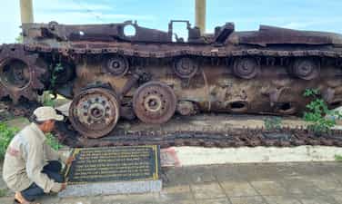
The Van Tuong Victory national relic complex is located in Binh Hai and Binh Hoa communes, Binh Son district, Quang Ngai province, and was ranked as a national historical and cultural relic in 1982. The complex includes 8 relic sites, including Loc Tu steel trench, Ngoc Huong hill, An Cuong beach, Phuoc Thien beach and the Liberation Army Regiment 1 headquarters. This place marks the battle of Van Tuong on August 18, 1965, when our army and people fought against the "Starlite" operation of the US army. With the coordination between the main force, local troops and guerrilla militia, the Liberation Army took advantage of the terrain, trenches and flexible fighting style to defeat the enemy's large-scale "search and destroy" operation. The Van Tuong victory has a particularly important meaning, proving that our army and people are capable of defeating the American army even though the opponent has superiority in numbers, firepower and war means. This is considered one of the typical battles, opening the "climax of destroying America" on the southern battlefield. Today, relics and the Van Tuong Victory Museum are places to store artifacts and images of historical battles, and are also places to educate about patriotic traditions and the resilient fighting spirit of Quang Ngai's army and people. Source: Quang Ngai Provincial Youth Union
Quang Ngai
427 view
Rating : National monument
Ba Gia victory relic
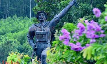
Ba Gia Victory - A historical milestone in the homeland of Quang Ngai. The Ba Gia victory is one of the typical victories of the army and people of Quang Ngai in the resistance war against the US, contributing to the bankruptcy of the US "Special War" strategy in the South. The campaign took place from May to July 1965, notably the battle at Ba Gia (former Son Tinh district) from May 29 to 31, 1965. In just two days and nights, the liberation army destroyed and disintegrated a mixed battle group of American and puppet troops, confiscating many weapons and means of war, affirming the maturity of the revolutionary armed forces. Today, the relic site still preserves many locations associated with victory such as Tron Mountain, Monkey Mountain, Chop Non Mountain, Phuoc Loc trench and high point 47. Ba Gia Victory Monument was built at the foot of Tron Mountain, becoming a red address to educate patriotic and revolutionary traditions for generations. With special historical value, Ba Gia Victory Monument was ranked a National Historical Monument in 1991, a meaningful destination for tourists who want to learn about the nation's heroic history of struggle. Source: Quang Ngai Provincial General Library
Quang Ngai
717 view
Rating : National monument
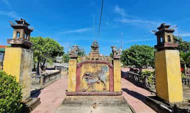
Ong Pagoda
Ong Pagoda (Quan Thanh Tu) is located in the town of Tu Thu Xa, Nghia Hoa commune, Tu Nghia district, 10km from Quang Ngai city to the east. The pagoda was made by 4 states of Hoa Minh Huong (Fujian, Trieu Chau, Hainan, Guangdong) living in Thu Xa Kien area in the second Minh Mang year (1821) and has undergone 4 restoration in 1881, 1894, 1920, 1991. Ong Pagoda worships Quan Vu in the main hall, worshiping Avalokitesvara Bodhisattva (people of China and Vietnam called Buddha Quan Am Nam Hai) in the harem space in the model of "Money Holy Buddha". In addition, the harem also worshiped Thien Hau, Kim Dau and 12 midwives. In terms of scale, although Ong Pagoda seems humble compared to the temples worshiping Quan Cong in Hoi An (Quang Nam), there is a harmonious combination of flower -Vietnamese architectural elements in a whole rich aesthetic. According to the profile of the General Museum of Quang Ngai province, the pagoda has a total area of 2,730m2, including temple garden, Tam Quan, pagoda yard and pagoda. All are surrounded by round 1, 1.2m high, 0.5m thick in a parallel style. The pagoda turned to the east. From the outside, the architectural works are arranged on a trary axis, tightly layout, posted in sequentially including: Tam Quan, Binh Phong - Tieu Tieu, Trong - Bell floor and temple. On both sides of the facade, there are two low gates, behind the temple is the temple to worship Tieu Dien Sy. Tam Quan gate structured one space, four columns, two sets because of the anti -fruit, in the way of the diaphragm. The third diaphragm bends the shape of the boat decorated with the head of the phoenix tail. The diaphragm is linked through the husbands and gloking through the column head. The roof of the tam tile roofed with yin and yang tiles, the top of the boat bent the boat, decorated the dragon shape, the tail covered with vegetable vines. The roof is decorated in the form of a box with five decorative cells. The two sides of the three gate are the temple of Ba Thien Hau. Battan Phong 2m high, with three compounds, the front covered with tiger shaped tiger bared the tail to look very vivid, the back covered the shape of the glass on the roof cluster. On both sides of Binh Phong are two pillars. Bell floors, drum floor built posted through the axis. Ong Pagoda currently holds 6 steles, epitaphs of Han characters, created in 1895 (7th Thai Thanh), 1920 (5th Khai Dinh), which are the years when the temple restores. Decorative stone stele touches the dragon painting in the forehead, the brazen beer is decorated with the dragon's head wrapped in a vegetable vine. The epitaph records the list of people who worship the money, including the name of the person, the place of residence, and the amount of money. In general, the art of decoration at Ong Dat Pagoda is quite sophisticated, especially the technique of embossing, touching, puncturing, touching on the screen, wooden walls, worshiping, trap, pattern, husband, statue, briefcase ... Ong pagoda has a harmonious combination of architectural elements of Vietnamese and Chinese people. In addition to the main components and materials of the traditional communal house in the Central region (the baseballs' husbands, the fake husband's husband) also has the appearance of the hiding of the planet of the Northern Delta and the set of the pumpkin husband's style of the North China style. Ong Pagoda was recognized by the Ministry of Culture and Sports (now the Ministry of Culture, Sports and Tourism) to recognize the national monument under Decision No. 43 of the Culture/Decision on January 7, 1993. Source of Quang Ngai Electronic Information Portal.
Quang Ngai
5454 view
Rating : National relics.
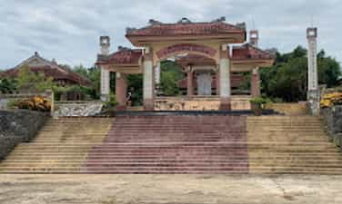
Truong Dinh Temple
Truong Dinh Hero is a famous hero in Vietnamese history in the fight against the French colonialists in the period from 1859 to 1864. Truong Dinh was born in Tu Cung village, Quang Ngai province. He followed his father to the South and established Tan An and Dinh Tuong. Truong Dinh led the army to raid the French plantation after the French army attacked Gia Dinh in 1859. However, when the court signed the Nham Tuat Peace Contract in 1862, yielding to three Eastern provinces to France, Truong Dinh Dinh Do not accept the beach and take office in An Giang as the court's order. Instead, he continued the war with the title of Binh Tay Dai Marshal, with the support of the people and the Confucianists. His fight against French was shocked with many illustrious feats. However, on August 19, 1864, in the dark leaves in Go Cong Dong, Truong Dinh was seriously injured. In order to preserve the honor, he decided to commit suicide at Pond Dinh, Go Cong, causing his people and soldiers to be heartbroken and regretful. After Truong Dinh died, King Tu Duc awarded the title and built a temple in Tu Cung village, Quang Ngai to commemorate him. Truong Dinh Temple, currently located in Khe Thuan hamlet, Tinh Khe commune, Quang Ngai city, Quang Ngai province, is the place to worship the national hero Truong Dinh. The temple was ranked by the People's Committee of Quang Ngai province in 2014, and recognized as a national historical monument on February 24, 2023. Source of Quang Ngai Electronic Information Portal.
Quang Ngai
5757 view
Rating : National relics.
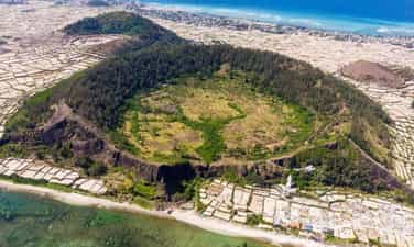
Gieng Tien mountain relics
Gieng Tien and Thoi Loi volcano are two unique mountains in Ly Son Island, Quang Ngai, belonging to the group of 10 volcanoes discovered in this area. Gieng Mien volcano, 86m high, has hundreds of meters wide, covered with fertile red soil and green all year round. At the foot of the mountain is Chocolate Pagoda, with the statue of Quan The Am 27m high, considered to protect fishermen at sea. Standing from the top of Gieng Tien Mountain, you can see the panoramic view of Ly Son Island and see the baby island in the middle of the sea. Gieng Tien Mountain, also known by the locals, is located in the territory of Tay village, An Vinh commune, Ly Son island district, Quang Ngai and is the second largest volcano on the island. This volcano has a height of 90m, an area of about 0.45 km2 and the diameter of the operating range is 500m. This volcano has a very round and pointed mouth shape, like the image of a coin, also because of this special shape that the locals have named the Gieng Tien mountain. Gieng Tien Mountain also has geological characteristics similar to Thoi Loi volcano, when undergoing erosion, creating stone walls, which the people used to create steps to lead to the crater. Gieng Mount Mountain was formed from a prehistoric period of about 3,000 to 4000 years ago. Therefore, this mountain has witnessed extremely prominent events of the geological formation process on the island. Since then, the landscape and geology here are also very special, this place has each layer of ashes falling into the debris that has accumulated when volcanoes operate on the slope of the volcano and almost no ruins of Sea ink on the cliffs. Because of the geological creation over time, the walls of the volcano here have also been worn out to create a beautiful scenery not inferior to the commercial - Thoi Loi. During the advanced sea, the peak of the mountain was also submerged in the sea in different stages when the cliffs were worn out, revealing very beautiful sections. A very strange thing is that although the co -volcano money on Ly Son Island has a very fertile red soil, there is no species that can grow on it. Explaining this, the people of the island district think that this is a sacred land, so the trees cannot grow on it. People also brought this sacred land to work as the core of the windy tombs scattered throughout the region. In January 2020, Mount Gieng Mon Mountain was decided by the Ministry of Culture, Sports and Tourism to be one of the national historical sites. Source of websites of Ly Son district, Quang Ngai province.
Quang Ngai
5735 view
Rating : National relics.
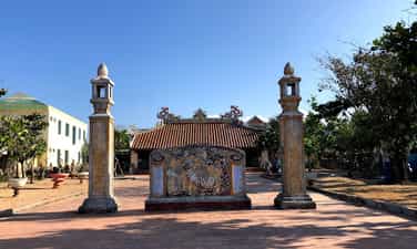
An Vinh communal house
Dinh An Vinh relic was built in the late 18th century, located in Ly Son Island, Quang Ngai. The communal house is not only a place to store traditional culture and sacrifices, but also an important symbol of Vietnam's sovereignty over islands and islands. An Vinh communal house has many times witnessed historical events, from separating An Vinh ward Cu Lao Ré to wars with the French colonialists and the American imperialism. Not only is the place to store antiques, An Vinh Dinh relic is also a place to record historical marks with Hoang Sa team, a team of fishing soldiers to protect the sovereignty of the sea and islands. This is also the starting point of the family of Vo Van, Nguyen, Pham Quang, Le, Vo Xuan, Dang, famous families participating in Hoang Sa team. The architecture of the communal house with the three -shaped and decorated patterns of the four spirit, the five Phuc shows the belief that pray for peace for the people. An Vinh village communal house is not only a spiritual symbol for the people of Ly Son island, but also an important historical monument of Quang Ngai, a testament to the sovereignty of Vietnam's sea and islands on the two archipelagos of Hoang Sa and Truong Sa. . In 2013, the Ly Son Quang Ngai relic was recognized by our State as a national historical monument. Source of websites of Ly Son district, Quang Ngai province.
Quang Ngai
5655 view
Rating : National relics.
Dinh An Hai
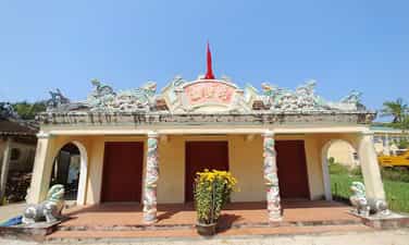
An Hai communal house is located on Ly Son Island, Quang Ngai Province. The communal house is the place to worship the gods and money of Ly Son Island. Thereby showing the relationship between Vietnamese culture on ancient Chama culture. An Hai communal house was built in 1820. Therefore, the communal house has a design style, ancient and solemn architectural architecture. An Hai communal house was built by 8 Tien Hien family and the villagers together to build the communal house. However, later Le was eliminated from the list of money due to violations of the communal house. From 1820 to now, An Hai communal house has experienced many additional constructions and built more projects. Therefore, the current architecture of the communal house has changed a number of changes compared to the original. The communal house was built with the direction of the sea, behind the Thoi Loi mountain and in front of there were two pillars with the nghe placed on the top. The architecture inside An Hai communal house includes Tien Duong, Hau impregnated and decorative details such as gongs, drums, and soul altar. The communal house has a layout style in the concept of Yin and Yang, showing the desire to peace through the design and decoration motifs of Mesopotam, Long Phung, Ngu Phuc ... Despite many changes, but the relic of Dinh Dinh An Hai still retains the unique beauty, typical of ancient architectural style, showing the solemn and ancient communal house. In 1995, An Hai communal house relic was ranked as one of Quang Ngai historical sites recognized as a national historical monument. The web portal of Ly Son district, Quang Ngai province.
Quang Ngai
5449 view
Rating : National relics.

Cao Cao 601 revolutionary historical relic
17 km north of Kon Tum town along Highway 14, there is a place that many of us know, which is Doc Dau Skull. Skull Slope is a new folk name that came into existence after the war in April 1972 between the revolutionary army and the enemy. The Ba Na people in this area call that place Kon Loong Pha, which means a slope with many Trac trees and High Point 601 is a military term for the enemy's military base on K-Rang Loong Pha hill. Until early 1972, the high point was still an important military point of the enemy, including artillery and tank positions arranged on two saddle-shaped hills. In the north, there is Ha Mon Security Station, guarded by the 23rd Security Battalion, with reinforced armored vehicles. In the south, there is the 3rd Airborne Brigade Headquarters, a large artillery field, tanks, and armored vehicles. There are also enemy artillery positions and Security posts in Kon Trang K-la; Ironing yard; North of Kon Tum town... With an important military strategic position, capturing high point 601 means controlling most of Kon Tum town as well as the entire Dak To - Tan Canh region. Capturing High Point 601 means completely mastering strategic road 14, the northern section of the Central Highlands. Realizing the importance of High Point 601, we were determined to capture it, and on the enemy side, they also tried to defend themselves by all means. On April 10 and 11, 1972, with the spirit of determination to fight and determination to win, we won a big victory at High Point 601. Results obtained: Destroyed 2 enemy armored squads, a convoy of goods, destroyed Destroyed 28 vehicles (including 14 tanks, M113 armored vehicles and 14 transport vehicles), destroyed 72 tons of military equipment and supplies, destroyed a security platoon, severely damaged 2 parachute companies, suffered heavy losses. Damaged the headquarters of the 23rd Airborne Brigade, a mortar battlefield, destroyed hundreds of enemies, shot down 2 planes, destroyed 2 106.7 mm mortars, captured more than 15 guns of all kinds, we cut off completely route 14. Together with local soldiers and guerrilla militia, this was a highly effective traffic cutting battle of the 28th Regiment in the Spring - Summer 1972 campaign in the Central Highlands. Since the signing of the Paris Agreement (from early 1973 to 1975), the area of High Point 601, KRang Loong Pha Slope (Skull Slope) and the entire Dak La and Ha Mon area have been disputed areas between us and the enemy. . Many fierce political struggles took place here, sometimes even using military weapons to win every inch of land with the enemy: With the correct policies of the superiors combined with intelligence, strategy and the heart Through the courage of our army and people, despite many hardships and sacrifices, we were able to maintain the entire liberated area of Dak To - Tan Canh to Dien Binh and Ha Mon and control the Dak La area, contributing to liberated Kon Tum town in the spring of 1975. Over the past years, Kon Tum General Museum has listed relics throughout the province, of which High Point 601 is a revolutionary historical relic that is of great interest to provincial leaders as well as the Culture sector. Recently, the Provincial Museum has compiled a scientific profile for the High Score 601 historical site to request a ranking. Although late, this is a truly meaningful work. More than 30 years after the victory of High Point 601, due to human impact and the harsh natural environment, the relic is only a vestige, but it is still convincing. Revolutionary historical relic High point 601 was ranked as a provincial-level relic by the Provincial People's Committee on May 17, 2003. Source: Dak Ha district information portal
Quang Ngai
6797 view
Rating : Provincial level relics