Relic point Vietnam
Việt Nam
Mo Dao Tan
Dao Tan (Dao Dang Tien, Dao Tien), self -ending, Mong Mai, Mai Tang, born in the year of the Snake (in 1845). Mr. hometown of Vinh Thanh village, Tuy Phuoc district, now belonging to Vinh Thanh village, Phuoc Loc commune, Tuy Phuoc district, Binh Dinh province. He passed a bachelor's degree in Dinh Mui (1867), 4 years later, King Tu Duc invited him to the Hue court signal, specializing in the plays under the king's order. In Giap Thin (1904), he retired after holding the position of the Ministry of Public Affairs. He was a famous patriot Thanh Liem, and a poet, editor and excellent drama director of Vietnam in the late nineteenth century and early twentieth century. With great contributions, Dao Tan was worshiped as the "post -ancestor" of Vietnamese classical art. Mo Dao Tan was started after he died in his hometown on July 15, 1907 (19th year of Thanh Thai) according to the national court ritual. His tomb is located on Huynh Mai Mountain (Hoang Mai) in Huynh Mai village, Phuoc Nghia commune, Tuy Phuoc district, 15 km from Quy Nhon city. Mo looked south, towards the village where he used to live. The tomb of Dao Tan is 3 meters long, 2 meters wide, in front of the tomb, there is a stele at the time of setting up a tomb and Binh Phong. Around the tomb is a rounded rectangular campus, before the gate, the back has a letter with a letter. Before and after the tomb, there were 4 lions standing adoration, the tail was raised upwards, and the face looked out in the main direction. This monument was ranked by the Ministry of Culture and Information on January 24, 1998. In 1994, the Department of Culture and Information of Binh Dinh coordinated with the People's Committee of Tuy Phuoc district and Phuoc Nghia commune to reinforce and relocate Dao Tan tomb based on the original. Today, the Mo Dao Tan relic is the sightseeing place for tourists from near and far to admire the artist who has dedicated to the art, where the incense offering the talented celebrity of the country by the Culture - Culture industry - News of the province and People's Committee of Tuy Phuoc district held on July 15 of the lunar calendar every year. Source of electronic portal of Binh Dinh province.
Gia Lai
4866 view
Rating : National relics.

Nhan Son Pagoda
Nhan Son Pagoda is called Ong Da Pagoda, located in Bac Nhan Thap village, Nhon Hau commune, An Nhon town, 23km northwest of Quy Nhon city. The temple is located under a shadow of a mango garden, leaning against Long Cot mountain, in front of a lotus lake with poetic scenery. Nhan Son Pagoda has a great value in history and art, which is the loser between the indigenous and Vietnamese culture, which is more especially the two giant sandstone statues worshiped inside the temple campus - A Cham sculpture. These are the two dvarapalla statues (subjects) with the meaning of the guardian of the Dharma, standing symmetrically 2.3m very vivid. The sculpture art has a typical style of Champa sculpture art in the 12th century, XIII. Two stone statues are painted black and red symbolizing Mr. Thien and Mr. Evil in the Vietnamese beliefs. In 2011, this temple was ranked by the Ministry of Culture, Sports and Tourism; The place of storing two statues of God - the work of Cham sculpture in the thirteenth century. Source of electronic portal of Binh Dinh province.
Gia Lai
4873 view
Rating : National relics.

The monument of the dock is not exposed
The ship is not arrived at Lo Dieu Ben, which is the first weapons shipping ship for Military Region 5 and is the only non -numerical train arriving at Binh Dinh beach. Hero of the people's armed forces, Lieutenant Colonel Ho Dac Thanh, former captain of the free ship, were participants in transporting 3 weapons to Phu Yen province in particular and 12 trips to the South in general. The weapons brought in by non-numerical ships have contributed to the victory of An Lao, Deo Nhan-Duong Lieu, contributing to changing the situation of the Southern battlefield to reach the reunification of the country. The non -Lo Dieu wharf relic is invested 15.8 billion dong, built on an area of 15,000m2. The highlight of the monument is a part of the ship made of stone, simulating the old ship in the past. This is the place to remember the merits of the "NO 401" soldiers and a revolutionary traditional educational place for people in Hoai Nhon district. Source of electronic portal of Binh Dinh province.
Gia Lai
4926 view
Rating : Provincial relics

Phu Loc Tower (Golden Tower)
Phu Loc Tower is also known as Thoc Loc tower, Phoc Loc tower, or a golden tower (Tour d'Or) as the French researchers have called, is an ancient Cham Pa tower in Nhon Thanh commune, An town Nhon 35km north of Quy Nhon city. This is a tower of Binh Dinh style, but at the same time, architectural style has partly influenced by the Khmer Angkor architecture. The tower is built on a hill top of 76m, so Phu Loc tower stands out in the middle of the plain of Binh Dinh province as a huge lighthouse. Like pacifying towers, tiles, especially the tiles in the corner, the vertical cells between the strong protruding columns and completely to smooth. The fake doors have three bodies and three floors like in the Tien and Thu Thien towers. The upper part of the fake doors is a long pointed arch that looks like a spear -shaped nose, both the remaining floors of the tower are repeating the style and layout of the body. Phu Loc Tower, built in the early 12th century, has a Binh Dinh style. This was a period of regular fighting between Cham Pa and Kingdom of Khmer, a study said that this tower was built during the Khmer army that was occupying the capital of Vijaya, Binh Dinh by the Cham king. Vidyanandana was built by the Khmer, so the architecture and art of Angkor greatly influenced this tower. The tower has a arrogant but sad beauty, standing from the foot of the tower, visitors can see all 4 directions of the surrounding scenery. The tower was ranked by the Ministry of Culture and Information of Architectural Architecture in 1995. Source of electronic portal of Binh Dinh province.
Gia Lai
5352 view
Rating : National relics.

Duong Long Tower (ivory Tower)
Long Duong Tower in Tay Binh commune, Tay Son district, about 50km from Quy Nhon city, was built in the late 12th century, this is the most brilliant development period of Champa culture. This tower cluster consists of three towers: the middle tower 42m high, the South tower is 36m high and the North tower is 34m high. The body of the towers made of bricks, the corners are paired with elaborate carved rocks. The size of Duong Long Tower is expressed not only in its height (the highest of the remaining Cham towers in Vietnam) but also in the unique architecture, especially the patterns and motifs engraved. Streamed on the massive rocks placed at the top of the tower with the skillful sculpture sculpture, the expressions are both monumental and splendid, delicate, soft, decorative animals and motifs. Both realistic, magical mysterious. Duong Long Tower is considered as one of the most beautiful Cham towers in Vietnam. Duong Long Tower was ranked by the Ministry of Culture and Information as an architectural monument in 1980 and ranked as a special national monument by the Prime Minister on December 23, 2015. Source of the portal port of Binh Dinh province
Gia Lai
5014 view
Rating : Special national monuments.

Thu Thien Tower
Thu Thien Tower is an ancient Cham Pa tower located on the south bank of Con River, located in Thu Thien village, Binh Nghi commune, Tay Son district, Binh Dinh province Up to now, the tower is still quite intact. Unlike some other Cham Pa tower clusters, Thu Thien tower is a monument with only one tower. Before 1985, on the top of Thu Thien tower was covered by a massive banyan tree on the top of the tower, in the 1980s, the entire Thu Thien tower was like turning into an ancient banyan tree, no one dared to cut this banyan tree because of the whole. The tower and trees both become sacred, the same thing is with other towers with trees growing on. However, the storm in 1985 landed in Binh Dinh province blowing a giant banyan tree from the top of the tower, but it was very strange that the banyan tree poured down without greatly damaging this ancient Cham tower. Like other traditional Cham towers, Thu Thien Tower is a square floor tower architecture including the body and three floors above simulating coal tower but smaller. On the outer walls of coal and the tower floors are adorned with small pyramids, heads and walls of the corner walls have protruding stone sculptures, but in Thu Thien tower, smooth, flat and flat columns Without decorative patterns, the umbrellas on the wall between the columns are not only carved with patterns but also turn into a loud base of strong protruding. The fake doors in the middle of the three sides of the West, the South, the North and the Eastern doors were all as large as the giant tip of the upper spear, the heads of the columns combined into a strong protruding roof, small towers in The corner of the roof floors is no longer a miniature tower but turns into a multi -layer pyramid. The tower dating back to the 11th century in the transition period between My Son A1 style and Binh Dinh style but bold style of Binh Dinh more. , mysterious. The tower was ranked by the Ministry of Culture and Information of Architectural Architecture in 1995. Source of electronic portal of Binh Dinh province.
Gia Lai
5183 view
Rating : National relics.

Little Cake Tower (Silver Tower)
Built in the late 11th century, the beginning of the 12th century in Phuoc Hiep commune, Tuy Phuoc, on the top of a hill between two branches of the Kon River, Tan An and Cau Ganh next to National Highway 1A, Quy Nhon City 20km. This is a population of 4 towers, standing from afar looks like a little cake, so people here call it little cake tower. The tower is also known as the silver tower because when studying this architectural complex, the French name the tower as the tour d’Argent (silver tower). Each tower here has separate architecture, different shades. In terms of art, in the entire Cham tower relic in Vietnam, the cake is less architectural complex with a diverse architectural appearance, beautiful decoration, with high artistic value. This tower cluster was ranked by the Ministry of Culture and Information Architectural Architecture in 1982. Source of electronic portal of Binh Dinh province.
Gia Lai
5137 view
Rating : National relics.

Cha citadel relics
In its golden age, the city was called Buddha Tathagata, the capital city of the capital Vijaya. This is one of the four ancient Champa citadels in Binh Dinh, once the economic and political center of this area from the 8th to the 15th century. Cha Citadel is located south of the Vijaya citadel, now in the territory of An Thanh village, Nhon Loc commune, An Nhon district - Binh Dinh. Located on a high strip of land on the south bank of the Kon River, Cha Citadel consists of two large and small citadels built close to each other (also known as the inner citadel and outer citadel), both with a rectangular plan. In the large citadel area, pairs of citadel walls face each other with negligible length differences. When building, the ancients relied on the direction of the Kon River, so the length of the northern wall was about 100m longer than the southern one. The east and west pair of walls are nearly 350m long, while the north and south pair of walls are nearly 950m long. Except for the north side of the citadel, which was mostly eroded due to its proximity to the Kon River, the remaining sides are relatively intact. In the northwest corner of the citadel area, there are also traces of a rectangular campus, surrounded by a brick mound in which a very large number of remaining bricks and tiles with thresholds and door pillars of different sizes are found. large, especially with many yin-yang bricks and roof tiles - decorative architectural materials only found in the old capital of Champa like Tra Kieu. In this area, people discovered a beautiful bust of the goddess Kabera Yakshini along with elaborate reliefs made of terracotta, proving the real existence of an architecture. urban. The small citadel is located back-to-back with the large citadel in the northwest direction, with a width of 134m and a length of 240m. An interesting thing here is that the creator of this ancient Buddhist citadel deliberately arranged two large and small citadels in a continuous pattern, shown in the fact that the eastern wall of the small citadel is also a part of the wall. To the west of the big citadel, another section is added. In this small citadel, no trace of the wall was found on the north side and it used the Kon River as a moat to create a shield to protect the citadel. This shows that the small citadel was arranged by ancient people as an outpost of the large citadel, a very important waterway transportation route. Citadel Cha is a citadel that also has many other names in folk culture such as Citadel Hoi, Citadel Ho Xu, Citadel Bac, Citadel Cu... but the most common name is Citadel Cha. The large citadel is located to the east. The north side of the wall runs west-east, 947m long, 3 to 5m wide, and currently about 1m high. In the middle of the citadel wall, there is an 8m high mound, gradually sloping towards the two sides of the citadel, called the Flag Pillar Mound. The southern wall has a similar length, but has been eroded, remaining only slightly above ground level. The most visible relics are the two eastern and western walls. The eastern wall runs north-south, is 345m long with an average height of 4m, and the wall is over 30m wide. The western wall has the same length and height, but the surface is narrower, about 7 to 10 meters. The northwest corner of the large citadel is surrounded by two sections of the citadel wall, one running from the Flagpole mound to the south with a length of 240m and a section perpendicular to it running to the west, connecting with the western wall of the large citadel to form a rectangular campus. In the middle of this campus there is a large mound of bricks, the remains of a collapsed structure. The smaller rectangular citadel is located adjacent to the northwest of the large citadel with a length of 440m and a width of 134m. Thanh Cha Relics was ranked a national historical and cultural relic by the Ministry of Culture, Information and Sports on November 27, 2003. Source: National Museum of History
Gia Lai
6877 view
Rating : National monument
Gia Lai Provincial Party Committee Historical Relic Area (Zone 10)
Revolutionary base Zone 10 (now Krong commune, Kbang district) converges all the elements of "favorable weather, favorable terrain, and harmonious people", and was chosen by the province as a "Safety Zone" during the 20 years of the war. resistance war against America to save the country (1955-1975). Although the enemy mobilized many means and forces and used every means to attack, the Revolutionary Base Zone 10 always stood firm, ensuring the safety of the headquarters of Gia Lai province. The construction site of the Revolutionary Base Zone 10 was originally a continuous base of 3 Northeast Gia Lai districts during the resistance war against the French. This complex base includes 3 communes: Lopa (Plei Kon district), Hon Nong (Nam Kon Plong district), Bonam and part of Nam commune (An Khe district). The terrain is high mountains, dense forests, divided rivers and streams; The three sides East, West and North rely on the mountain position; The southern side is adjacent to the An Khe depression, advancing can fight the enemy, retreating can stand still and calmly raise and train troops. This place has a cool, humid tropical climate. Most of the residents are Bahnar people with a tolerant, hard-working, hard-working nature, and live faithfully following the Party and Uncle Ho. During the resistance war against the French colonialists, the people here did not cooperate with the enemy, many villages before 1945 were still outside of the enemy's control. This area became a communication corridor, a supply corridor, and the advance of armed propaganda teams, and armed teams from the delta advanced to the North Pleiku and Northwest Route 14 areas, expanding their base. In the years 1950-1954, this place was the base of main army units to attack the enemy in the An Khe and South-North Route 19 campaigns. At first, the Provincial Party Committee had only 8-10 people. After that, the movement developed, especially when the National Liberation Front of the South was born (1960), then when the Provisional Revolutionary Government of the Republic of South Vietnam was established, the departments and branches of the province also formed. In addition to key agencies such as: Provincial Party Committee, Liberation Government, Front, Military Committee, there are also specialized departments: Economy-Finance, Culture, Education, Health... In difficult times Despite hardships and dealing with the enemy's destructive war measures, the agency's officers united with the army and people to survive, both producing and fighting against the enemy, maintaining the base. Not only is it the province's revolutionary base, Area 10 is also a shelter for a number of agencies of Inter-Zone 5 and neighboring provinces during enemy raids and raids in the delta. In particular, Area 10 is also the location of intersection stations - an important link of the North-South Central corridor and the East-West corridor parallel to National Highway 19. Even though it suffered under the rain of bombs and storms of bullets from the enemy, under the protection and protection of the mountains and forests and people here, the Revolutionary Base Zone 10 always stood firm, ensuring the safety of the units. The province's headquarters operated and led the successful resistance war against the US, liberating the province on March 17, 1975, contributing to liberating the South and reunifying the country. With the principle "When drinking water, remember its source", on March 17, 2017, the Provincial Party Standing Committee decided to start construction of the province's revolutionary historical relic site in Krong commune. The relic area is designed to simulate works during the resistance war against the US to save the country, including: Secretary's shack, Deputy Secretary's shack, Cipher's shack, Office shack, A-shaped cellar, dining room, Royal kitchen. Cam, memorial house, stele house recording events; At the same time, restore the forest and protect the ecological landscape in the relic area. On May 19, 2018, the Revolutionary Base Area 10 was inaugurated. This is a "red address" to educate patriotism and revolutionary traditions for officials, party members and people of all walks of life in the province, especially the current young generation who always remember their merits, dedication, the selfless sacrifice of his father's generation in the struggle for independence and freedom of the nation. Source: Gia Lai Electronic Newspaper
Gia Lai
5646 view
Rating : Provincial level relics

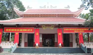
Martyrs' Tomb Memorial Temple
The historical relic of Martyr's Tomb Memorial Temple is located on Nguyen Viet Xuan street in residential group 11 (now residential group 3), Hoi Phu ward, Pleiku city, Gia Lai province. The historical relic of the Martyrs' Tomb Memorial Temple in Hoi Phu is the resting place of more than 200 martyrs who heroically fought and died during the 1968 Tet Offensive and Uprising in Pleiku town - Gia Lai. The 1968 Tet Offensive and Uprising took place in Pleiku town, starting from the night of the 30th to the morning of the first day of the 1968 Tet Offensive and lasting until the 3rd day of the Lunar New Year, with nearly a dozen units from the company arriving. The battalion and civil service officers attacked Pleiku town and attacked many enemy headquarters. In particular, the force of Zone 9 (Pleiku town - now Pleiku city) includes special forces company C 90 and special forces company C21; Summary of the 1968 Tet Offensive and Uprising campaign in Pleiku town: The army and people of our province (mainly the Pleiku town front) killed nearly 3,500 enemies, destroyed 500 military vehicles, 35 artillery pieces. and a number of aircraft of all types, burning nearly millions of liters of enemy gasoline. In coordination with the military attack, 11,000 people took to the streets to protest for political struggle. Revolutionary governments in a number of hamlets and communes in districts (Zones) 3, 4, 5, 6 were established. More than 14,000 compatriots destroyed strategic hamlets and returned to their old villages, and 11 villages on the outskirts of town were liberated. After the General Offensive and Massive Uprising of the Mau Than Tet, General - Vo Nguyen Giap, on behalf of the Standing Committee of the Central Military Commission, sent a telegram "warmly praising the recent achievements of the army and people of Buon Ma Thuot town, Kon Tum, Pleiku and Tan Canh town". On February 6, 1968, our State commended and awarded the "Fatherland Merit Medal" to the soldiers and civilians of Pleiku town, and at the same time, the security forces of Pleiku town (Area 9) were also awarded the Meritorious Service Medal, class 1. 3. In 2020, the C90 special forces company was honored to receive the title of Hero of the People's Armed Forces. The 1968 Tet Offensive and Uprising had great significance for Pleiku town: Immediately after liberation, Pleiku town authorities always paid attention and took care of the common graves of martyrs. To commemorate the merits of the martyrs, the Party Committee and Pleiku town government did not move the remains of the martyrs to the cemetery but kept the same position. In 1993, Pleiku town rebuilt the mass grave on the spot with "The Fatherland Recognizes Merit" station and each side has a stele recording the units participating in the campaign and the number of soldiers and officers who died in the 1968 Tet Offensive and Uprising in Pleiku. From 2004 to 2005, the Party Committee and Pleiku city government renovated and rebuilt the common grave with solid reinforced concrete and spacious granite tiles at the old location. Newly built memorial temple, guest house, stele, and ornamental garden. In 2020, the bell tower was built and the guest house was renovated. With the value, meaning and importance of the monument to the historical development of Pleiku - Gia Lai, it is also the wish of the relatives of heroic martyrs from all parts of the country whose children died in the war. 1968 Tet Offensive campaign in Pleiku town. On March 5, 2007, the People's Committee of Gia Lai Province decided to classify the historical site of the Martyrs' Tombs Memorial Temple, group 11, Hoi Phu ward, Pleiku city, Gia Lai province, as a provincial-level historical relic. Every year, the Party Committee and People of Pleiku city organize a visitation ceremony, offering flowers and incense at the relic site, especially on the occasion of Lunar New Year, March 17, April 30, July 27, September 2 and other political events of the city. Source: Gia Lai Provincial Museum
Gia Lai
5792 view
Rating : Provincial level relics