Tourist destination

Dau Tieng Lake
Tay Ninh Dau Tieng Lake stretches across three provinces: Binh Duong, Binh Phuoc and Tay Ninh. The upstream of this lake belongs to Dau Tieng district, Tay Ninh province with a large area. Dau Tieng Lake is located about 25km east of the city center. Dau Tieng Tay Ninh Lake was started construction in 1981. After 4 years of construction, this artificial lake was completed on January 10, 1985. The capacity of Tay Ninh Dau Tieng Lake is estimated to contain about 1.58 billion cubic meters of water. Tay Ninh Dau Tieng Lake is the largest artificial lake in Vietnam. Not only does it play a role in coordinating water for the Saigon River, this lake is also a tourist destination that attracts many visitors. The space at Tay Ninh Dau Tieng Lake possesses charming landscape beauty and a cool atmosphere that will surely make you fascinated and forget the way home. There are many means of transportation for you to choose when moving to Dau Tieng Lake, Tay Ninh. You can ride a motorbike or taxi depending on your preferences and personal needs. Starting from the center of Tay Ninh city, you go along Cach Mang Thang Tam street and then turn to Ba Den Mountain. After arriving at Duong Minh Chau town, turn right and go straight about 2km along the dike road to reach your destination. Tay Ninh Dau Tieng Lake has long been famous for its poetic and romantic beauty. The clear blue lake surface, floating clouds combined with lush green grass promise to make you extremely fascinated. Watch sunrise and sunset at the lake. This is an interesting experience that you cannot miss when traveling to Dau Tieng Lake in Tay Ninh. In addition to exploring the natural landscape, watching the sunrise and sunset at the lake will bring you a feeling of extreme peace and relaxation. Tay Ninh Dau Tieng Lake appears like a poetic watercolor painting, making anyone lost in this place captivated with its beauty. When traveling to Dau Tieng Lake in Tay Ninh, you can take time to enjoy the delicious dishes below. Rice paper rolls dried in dew. This is a famous specialty of Tay Ninh Dau Tieng Lake that you must definitely try. The rice paper shell has a subtle rice flavor, the roll inside includes boiled meat, vermicelli, wild vegetables, bean sprouts, cucumber, pickled carrots... This rustic dish is loved by many locals. Trang Bang noodle soup is a memorable dish because of its rich, sweet flavor. Most local people know how to prepare this specialty dish. In addition, grilled fish with salt and chili is a dish that cannot be missed. The fish are marinated with spices to taste and will definitely make you pick up your chopsticks non-stop. This is a popular dish in Tay Ninh, making a strong impression with its naturally sweet, chewy fish flavor mixed with typical chili salt.
Tay Ninh
9644 view


Ma Thien Lanh tourist area
Ma Thien Lanh Valley carries with it many mysterious stories and legends that make anyone who hears them shudder because of its sacredness and magic. One of the most prominent stories told by local people originates from the resistance war against the French and Americans. The enemy troops that invaded our country had to go through the valley and more than 70% of the troops died in this holy place. The number of people left was so small that they were all easily defeated by our army. In addition, some people who have lived in Ma Thien Lanh Valley for a long time said that they have faced giant snakes, even cobras nearly as big as an adult's calf. However, up to now no one has been in danger from the venom of that ferocious snake, so it is only considered one of the mysterious stories of this sacred mountain region. Departing from Ho Chi Minh City, you can travel by motorbike or choose reputable Tay Ninh bus companies to travel to Ma Thien Lanh Valley. You go along National Highway 22A until you see Trang Bang intersection, then turn right onto provincial road 782. Then, you continue about 50km to reach Tay Ninh town. Here, you just need to go straight along the 3km long asphalt road connecting Provincial Road 782 to Phung Mountain and then go through a small road to Ma Thien Lanh Valley. This road is considered quite difficult to travel, so if you travel by motorbike, you need to have a steady hand on the steering wheel. If you depart from Tay Ninh city, moving to Ma Thien Lanh Valley is very easy. With a distance of only about 11km, you can go by motorbike to be more proactive with your time. From the center of Tay Ninh city, you can choose to go in the direction of Tran Phu or Boi Loi street. If you do not know the route clearly, you can follow the directions of Google Maps and rest assured that this road is very easy to follow. To discover the full beauty of Ma Thien Lanh Valley, you will have to walk and trek through mountain climbing paths and forests. This is a challenging but also very interesting road for those who love to explore and adventure. Throughout the trekking route of Ma Thien Lanh Valley, you will encounter a series of giant rocks and overcome countless steep, dangerous slopes one after another. Although the road is full of difficulties and challenges, during the trekking journey, you will be very excited to see with your own eyes the endless mountain scenery, diverse vegetation with countless rare and precious forest species. Hearing the gurgling stream mixed with the chirping of birds is extremely pleasant. Ma Thien Lanh Valley possesses a wild, primitive and mysterious beauty that makes anyone captivated. This place is also likened to Da Lat of the Southeast region because of its extremely magnificent natural scenery. Looking down from above, Ma Thien Lanh Valley looks like a giant basin covered with vast old forests. Adorning the impressive beauty are countless precious wood trees hundreds of years old such as ancient trees, eucalyptus... In addition, people in the area also grow many fruit trees here such as mango, rambutan, banana, guava. , plums... to increase the richness of this land. The entire Ma Thien Lanh Valley is like a natural picture that is both vast, majestic, mysterious and magical.
Tay Ninh
8402 view



Moc Bai border gate
Moc Bai border gate located in Loi Thuan commune, Ben Cau district is one of the international land border gates that began operating in 2004. Located on the Trans-Asia road extending from Myanmar through Thailand, Laos, and Vietnam. South, Cambodia and ending in China, this place receives many special advantages both in economic - cultural exchanges and tourism development. Currently, Moc Bai is a border gate area and tourist destination that attracts thousands of visits each year in the "holy land" of Tay Ninh next to Lo Go - Xa Mat National Park, Binh Thanh Ancient Tower, Chang Riec Forest... Here are some notes that everyone needs to keep in mind when coming to Moc Bai Border Gate to have fun: You absolutely should not pawn items to help strangers when passing through the border gate to avoid getting into trouble with banned substances as well as breaking the law. At the border gate, there will be many motorbike taxis to entice you to cross the border for prices ranging from 400,000 VND to 500,000 VND without a passport. This is a serious violation of the law, so everyone should pay close attention. The group moved to Moc Bai and planned to visit Cambodia, so they proactively exchanged money for convenient shopping. The corresponding exchange rate for 20,000 VND will be 3,500 KHR. Moc Bai Border Gate Area is located about 80km from the center of Ho Chi Minh City and about 170km from Phnom Penh Capital (Cambodia). Departing from Saigon to the tourist destination, you can book a bus ticket, limousine, take a bus or go directly to Tay Ninh by motorbike or personal car depending on your preferences and financial needs. Normally, limousines from 10 to 31 seats running the Ho Chi Minh City - Moc Bai route will cost about 1,800,000 VND/person round trip. After buying tickets directly or booking online at reputable agents, you will depart the trip at 302, Cong Hoa Street, Ward 13, Tan Binh District and stop at Moc Bai Border Gate. Some bus companies going to Tay Ninh that you can consider if choosing this long-distance vehicle are Dong Phuoc (hotline: 1900 1152), Thai Duong Limousine (1900 9227), Le Khanh (1900 7070)... For tourists traveling by motorbike or personal car, from Saigon you can drive along Highway 22 to Trang Bang district first. After stopping here, you go towards Go Dau town through An Thanh Commune People's Committee about 7.4km to the famous border gate area. Besides the supermarket, it would be a huge mistake if you come to Moc Bai Border Gate and miss the opportunity to try your luck at famous casinos such as Moc Bai Bavet, New World, Le Macau, Chateau, Las Vegas Sun... located towards Bavet (Cambodia) takes less than 5 minutes to travel. To enter the casino, you need to prepare a certain amount of cash to participate in the games. Around the casino, there are also many large-scale cockfighting arenas that often use Vietnamese dong or US dollars to bet. Depending on your financial conditions, you can choose entertainment spots that suit your interests and needs when you have the opportunity to stop here. After having fun at Moc Bai Border Gate, you can go through quite simple entry and exit procedures to travel to Cambodia to explore this beautiful country. Just travel about 170km by car or motorbike from Bavet Border Gate road, you can check-in at Phnom Penh - a place famous for its impressive Buddhist architectural works. Tuol Sleng Genocide Museum, Wat Phnom Temple, Central Market... are some attractions in the capital area that you definitely cannot miss.
Tay Ninh
13122 view


Binh Thanh ancient tower
Oc Eo culture is an ancient culture associated with the Southern region and the lower Mekong delta. Binh Thanh Ancient Tower is one of the rare remaining architectural masterpieces of this culture. Over the centuries, the ancient tower has still preserved its unique architecture almost intact and has become the most attractive tourist destination in Tay Ninh. Binh Thanh Ancient Tower was built in the 8th - 9th centuries and is now more than 1,000 years old. This is one of three typical architectural works of the Oc Eo culture remaining in the Southern region. The ancient tower is located on the right bank of Vam Co Dong river, in Binh Hoa commune, Trang Bang district, about 50km southeast of Tay Ninh city center. The Ancient Tower relic area has a total of 3 towers, but only the main tower is still intact, the main tower was restored in 1998. The remaining two towers have been destroyed, only the ruins remain. built on a square foundation. In the early twentieth century, Binh Thanh Tower and Tay Ninh Chop Mat Tower were discovered through archaeological reports at the Indochina archaeological research library. By 1993, these two towers were officially recognized as National Historical Monuments. Tay Ninh is in the Southeast region, the climate is temperate, divided into two distinct seasons: the dry season and the rainy season. The rainy season lasts from May to November, the dry season from December to April of the following year. The dry season in Tay Ninh is sunny but not too hot, suitable for outdoor tourism activities. If you want to visit Binh Thanh Ancient Tower, you should go in the dry season, so choose in the morning or late afternoon to avoid harsh sunlight. Binh Thanh Tay Ninh Ancient Tower is located on Provincial Road 786, in Binh Hoa commune, Trang Bang district. From the center of Tay Ninh city, you go along Highway 22B towards the center of Go Dau district, to the intersection of Voi hamlet (Ben Cau district), turn right to enter Provincial Road 786. From here, you run about 20km more. You will see a turn leading to the Ancient Tower. For convenience in visiting the Ancient Tower and famous tourist destinations in Tay Ninh, visitors should stay in the central area. In Tay Ninh, there are many types of resorts, with prices ranging from affordable to high-end. Depending on your needs, you can choose a suitable place to stay. Binh Thanh Ancient Tower was discovered in 1886 and is a rare architectural heritage of the Oc Eo culture that still retains its original construction design. Dating back centuries, this ancient tower has witnessed many ups and downs of Vietnamese history. Besides, Binh Thanh Tower also contains traditional cultural values, beliefs and religions of the ancient Funan people. The patterns and reliefs embossed on the tower are popular images in Hinduism, including stylized flowers and leaves, vitality, gods... These are symbols that Funan people worship and worship through. many centuries. The architecture, construction techniques and sculpture shown on the Stock Tower reflect the development to the pinnacle of Oc Eo culture at that time. These are valuable documents that help researchers learn and discover more unique historical and cultural values in this ancient relic. Besides, Binh Thanh Tower also contains traditional cultural values, beliefs and religions of the ancient Funan people. The patterns and reliefs embossed on the tower are popular images in Hinduism, including stylized flowers and leaves, vitality, gods... These are symbols that Funan people worship and worship through. many centuries. The architecture, construction techniques and sculpture shown on the Stock Tower reflect the development to the pinnacle of Oc Eo culture at that time. These are valuable documents that help researchers learn and discover more unique historical and cultural values in this ancient relic. With unique architecture, Binh Thanh Ancient Tower is a destination not to be missed for "virtual living" believers. The ancient tower has strange check-in corners, from mossy ancient walls to carved patterns on stone. Just lift the camera and you will have yourself an impressive set of photos. Besides, visitors coming here also have the opportunity to learn about historical stories and ancient Oc Eo culture.
Tay Ninh
8640 view


Ba Den Mountain
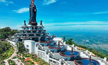
Ba Den Mountain is a famous mountain located in the cultural and historical relic complex of Ba Den Mountain and is associated with many legendary stories. With a height of 986m, Ba Den Mountain has become the roof of the Southern region and possesses majestic scenery amidst vast green rice fields. Currently, the mountain has been invested and built a campus with all kinds of flowers, blurry white clouds flying, creating a scene similar to Da Lat and especially the appearance of the Buddha statue of Tay Bo Da Son. highest in Vietnam. According to the current popular experience of going to Ba Den Mountain, you can conquer the mountain peak in many ways. Ba Den Mountain is a famous mountain located in the cultural and historical relic complex of Ba Den Mountain and is associated with many legendary stories. With a height of 986m, Ba Den Mountain has become the roof of the Southern region and possesses majestic scenery amidst vast green rice fields. Currently, the mountain has been invested and built a campus with all kinds of flowers, blurry white clouds flying, creating a scene similar to Da Lat and especially the appearance of the Buddha statue of Tay Bo Da Son. highest in Vietnam. According to the current popular experience of going to Ba Den Mountain, you can conquer the mountain peak in many ways. The ideal time to travel to Ba Den Mountain is from December to April. The weather at this time is dry and cool, very suitable for climbing and camping activities. In particular, during the Ba Den Pagoda festival season from January 4 to 16, you can come to pray for good things in this sacred land. For those who like to explore and experience the feeling of conquest, Ba Den Mountain will be an extremely wonderful place. According to experience traveling to Ba Den Mountain so far, there will be 5 routes with 5 different levels for you to choose from. The average time is about 3 to 4 hours depending on the route. And during the climb, when you stop to rest, you will enjoy the increasing beauty of the surrounding landscape. The higher you go, the more majestic and interesting everything looks. If you're lucky, on the way you will see white cloud friends hovering next to you. After reaching the top of the mountain, you must definitely check-in at the coordinates of Ba Den Mountain to save your glorious moment at the highest peak in Southern Vietnam. In addition, this place is surrounded by clouds all year round, creating an extremely magical space. Remember to capture these moments at the "cloud balcony". One of the important experiences when traveling to Ba Den Mountain that you must keep in mind is what to reward your belly with. Here are some suggestions that you can add to the menu to make your trip more complete: Tay Ninh young beef, Dew-dried rice paper rolled with pork, Tay Ninh grapefruit spring rolls, BBQ right at the top of the mountain...
Tay Ninh
8867 view


Standing Waterfall
Standing Waterfall is originally a waterfall in the flow of Dak Quottle stream, in Bu Dang district, Binh Phuoc province. This is a waterfall connecting two hillsides in Minh Hung and Doan Ket communes, about 6km from Bu Dang district center, 55km from Dong Xoai city center, and about 23km from Bu Lach Grassland. With a geographical distance not too far, you can absolutely choose to visit Standing Waterfall if you have the opportunity to visit Dong Xoai city. The name Standing Waterfall comes from the difficult terrain of this waterfall. The scenery of the waterfall is the image of tall rocks stacked vertically on top of each other, so the waterfall is called Standing Waterfall. Depending on each climate type, Standing Waterfall will have its own unique beauty that nothing can mix with. Standing Waterfall in the rainy season, with strong streams of water due to the high flow of water, Standing Waterfall is like a wave rolling vertically, water pouring back into the lake surface, rushing hard against the rocks, releasing bubbles. White. The scenery at Standing Waterfall at this time looks splendid and easily makes people excited. However, because of the strong flow, the terrain of Standing Waterfall now becomes complex and winding, making it difficult to move. The waterfall water in the rainy season is also yellow in color because the soil here is mainly red basalt soil. Standing Waterfall in the dry season, this place seems to be nestled among the noise of the mountains and forests. No longer rolling waves churning out white foam, Standing Waterfall now gently nestles in the rocks, pouring out charming blue streams. This is also the best time that you should visit Standing Waterfall, floating and enjoying the cool sounds of nature. The notable highlight of the waterfall is the tall rocks stacked on top of each other amidst the vast mountains and forests, creating a valuable watercolor picture bestowed by nature. Under the erosion of water and natural arrangement, the rocks around this area are often hexagonal or rectangular in shape. Dotted on the banks of Standing Waterfall are lush green lawns lying peacefully under the shady canopy of ancient trees. Looming in the background are orchids mixed with wildflowers as if adding to the sound of the mountains and forests. Standing Waterfall on quiet dry days, we can relax and soak in the cool spring water, enjoy the peaceful feeling that nature brings, and erase all the fatigue that everyday life brings. The area around Standing Waterfall is also a unique cultural space of the Stieng ethnic people. This place is often chosen as the place where festivals of the Stieng people take place. If you visit on the right occasion, you will certainly have interesting experiences as well as learn more about the unique cultural lifestyle of this nation. In addition, if you are a lover of camping, you can go to the waterfall peak area. This is an ideal place for communal activities and together watching the entire beautiful scenery of Standing Waterfall.
Dong Nai
5941 view


Thac Mo Lake
Thac Mo hydroelectric reservoir is located in two districts of Phuoc Long and Bu Dang of Binh Phuoc province. This is an artificial lake with an area of about 110km2 in the Thac Mo hydroelectric project complex. This place's main task is to provide water to surrounding areas as well as help Thac Mo hydroelectric plant produce electricity to serve people's daily activities. Besides, Thac Mo hydroelectric lake has a charming landscape with many cultivated plantations, green grasslands, open space and fresh air. This place is gradually becoming an attractive destination for young people who like to explore new and interesting things. Currently, Binh Phuoc province still does not have an airport, so if you are in the North and want to explore Thac Mo hydroelectric lake, you can move to Tan Son Nhat airport, Ho Chi Minh City. Then, from the airport continue to travel by bus from Ho Chi Minh City to Binh Phuoc to this attraction. With a distance of 154km, it will take you about 4 more hours to drive from the city center to Thac Mo hydropower plant. Don't be afraid of the long distance, the road to Thac Mo hydroelectric power plant will make you surprised by the beautiful and enchanting scenery. If you choose Ho Chi Minh City center as the starting point when traveling by motorbike, we will guide you on the route from Ben Thanh market to Thac Mo hydroelectric lake. From Nguyen Thi Minh Khai and Dien Bien Phu streets, you go straight to Xo Viet Nghe Tinh/National Highway 13 (5.3km). Then, go along Highway 13 to Go Dua Street in Thu Duc (7.8km). At the intersection between DT743 and DT745/DT747B, continue moving toward Nguyen Tat Thanh in Phuoc Long town (107km). Finally, after reaching Thac Me bridge at Duc Hanh (6.4km), run straight to reach Thac Mo hydroelectric power plant. Along the road to Ba Ra Mountain Thac Mo Binh Phuoc, you will admire many beautiful landscapes that cannot be found anywhere else. Here you can trek with friends and relatives to Ba Ra mountain. On the way, you will easily encounter perennial rubber forests planted in extremely poetic straight lines. If you are lucky enough to go here in the fall, this road will be tinged with a dreamy yellow color like a European scene. You can also see fruit orchards such as durian, rambutan, or vegetable plantations. If you want, you can visit, experience and pick vegetables and fruits at the garden to enjoy the fresh taste of newly picked fruits. Thac Mo Hydropower Plant is located at the foot of Ba Ra Mountain, as beautiful as a vast steppe. Because tourism has not been exploited much, the scenery here is still wild and has a poetic beauty. Try with the people to experience fishing right on the lake, vacation on a beautiful small island here or enjoy rustic grilled fish. On weekends, to avoid the hustle and bustle of the city, have a picnic with friends right at the Thac Mo hydropower grassland. The large, green lawn will be a place for you to release all daily fatigue and stress and immerse yourself in the open nature. Most especially, you will have the opportunity to enjoy fish dishes, eel from Be River accompanied by Ba Ra wild banana flowers and a few jars of wine by the red fire.
Dong Nai
7287 view


Stream lake
Suoi Giai Lake is a charming landscape located in Tan Lap commune, Dong Phu district. About 20 km from the center of Dong Xoai City, and about 80 km from the center of Ho Chi Minh City, Suoi Giai Lake is like a peaceful space nestled among the noise and dust of the city. The name Suoi Giai Lake comes from the connotation of Giai Nhan stream, which also means beautiful young woman. Therefore, the beautiful scenery here is often compared to a fairy descending to earth, gentle, gentle but no less flashy. Suoi Giai Lake is about 1.5 km wide, nestled between two hills, you can see the lake bed from above while driving. Review of Suoi Giai Lake shows that, in the past, Suoi Giai Lake was the upstream of a small stream. In 1978, after being approved by the Binh Phuoc provincial government, this place was converted into an irrigation dam with the task of storing and providing water for the use of the people here. Currently, this place is an interesting destination for the backpacking community, suitable for experiencing various types of activities such as camping, boating or fishing. Suoi Giai Lake is a large dam with a romantic and charming scene. At noon, the rays of sunlight shine down on the sparkling clear water, creating a very poetic and peaceful space. The most expensive scenery at Suoi Giai Lake must be at sunrise and sunset. When the sun appears and disappears, the scene seems to be dyed a brilliant orange-yellow color, lighting up the whole land and sky. On the lake bed, you can easily see the scene of a fisherman fishing and catching fish. It all took place under the sunset, painting a picture that couldn't have been more peaceful and romantic. Besides, when moving to Suoi Giai Lake, you will easily encounter wonderful and quite famous scenery. If you move from Binh Duong, you will pass by the Song Be Broken Bridge Relic, a famous place that appears quite a lot on the screen. In addition, when moving around the province, it will not be difficult for you to encounter Binh Phuoc rubber forests during the leaf-changing season. This is a place that many young people check in at the end of the year, when the forests are tall. The sun becomes bright yellow in a corner of Binh Phuoc sky.
Dong Nai
8957 view


Bu Gia Map National Park
Known as one of the famous national parks in Vietnam thanks to its diverse natural ecosystem, flora and fauna that contribute to creating impressive scenery. Bu Gia Map National Park is currently a famous tourist attraction that many people choose to visit when coming to Bu Gia Map district, Binh Phuoc province. Although it has been established for many years, it was not until 2002 that this place was officially converted from a conservation area to a national park. With a total area of 25,601.18 hectares and divided into many conservation areas for many rare plants, directly affecting the genetic research process of many precious plant species. In particular, the forest coverage reaches 90%, creating a habitat for many types of animals. Not only does it play a conservation role, this is also a national park that greatly contributes to protecting and regulating water sources for hydroelectric and irrigation lakes. Visitors to Bu Gia Map National Park will be able to admire the close natural scenery, admire the green beauty, discover many precious flora and fauna species, and participate in interesting activities. Characterized by a sub-equatorial tropical monsoon climate, the national park has two distinct seasons: sunny and dry during the year. In particular, the average temperature will be about 25.8 - 26.2°C, which is quite favorable for visiting and exploring the national park landscape during the trip. Therefore, you can schedule a visit to the tourist area at any time of the year. However, to have a smooth visit and keep many memorable memories, you should choose to go during the dry season. Specifically, from November to early May of next year, you should avoid going to Bu Gia Map National Park during the rainy season because it will make it difficult to move and see the scenery. After arriving in Binh Phuoc province, to have a memorable and easier trip to Bu Gia Map National Park, many tourists are interested in choosing a quality place to stop. With the strong development of the tourism industry and the large number of tourists visiting every year, here you can find many hotels in Binh Phuoc. In particular, depending on the needs and desires of each person, they can choose a hotel with suitable quality for themselves. Therefore, you do not need to worry about where to stay on this tour. Besides, visitors can also refer to hotels in Binh Duong or City. Ho Chi Minh if you plan to visit during the day or camp on site. Trekking activities are indispensable when visiting natural tourist destinations such as national parks. During this process, you will experience many adventurous activities, immersing yourself in exciting space and scenery. At the same time, this is also an opportunity to explore many species of flora and fauna preserved in the national park. In addition, Da Voi Beach and Dak Mai Waterfall are an interesting attraction located in the national park area. Not only is it a large area, but this place also possesses many giant rocks in the middle of lush cashew gardens. and create the majestic Elephant Rock. Besides, Dak Mai waterfall flows from Dak Nong through Bu Gia Map national park combining changes in height to create an impressive and beautiful waterfall. One of the great experiences when coming to the famous tourist area in Binh Phuoc is to enjoy delicious dishes that are uniquely prepared and attractive. Some outstanding dishes that are highly appreciated by many tourists include: beef soup, bamboo-tube rice, wild boar meat, etc. All of them use available ingredients grown by local people. Through skillful processing, it creates unforgettable specialties from the first time you enjoy it.
Dong Nai
8934 view


Bu Lach Grassland
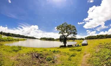
If you are looking for a spacious and cool camping location near Saigon, please refer to Bu Lach Glade. Located in village 7, Dong Nai commune, Bu Dang district, Binh Phuoc, this is one of the most attractive camping locations for tourists. Surrounded by primeval forests and a large lake in the middle, Bu Lach has a strangely pristine and peaceful natural scenery. This place was originally a cluster of nearly 20 grasslands of different sizes with an area of up to 500 hectares. The reason for its name is due to a misreading of the local language of the M'Nong people. The village elders explained that here the word "lach" in the M'Nong language means "glad", in the glade there is a water tank so it is called Bau Lach, if read incorrectly it becomes Bu Lach. The road to Bu Lach Grassland is not too difficult. If you are from Saigon, you can buy bus tickets at Mien Dong bus station. Ticket prices are usually from 100k to 250k. If you want to explore nature and travel, you can travel by motorbike. There are two directions to get to Binh Phuoc. One is from Binh Trieu Bridge to follow Highway 133. The second direction is from Saigon Bridge to Hanoi Highway. Travel time is about 2 hours and 30 minutes to arrive. Check-in to the grassland, visitors will be amazed at what nature has bestowed upon them. These are vast green lawns surrounded by clear blue water, surrounded by primeval forests. Just like that, one glade follows another, endlessly green. The glades are usually about 5-10 hectares wide, but Big Glade is the most beautiful and widest, nearly 100 hectares. Another unique feature is that there is only one type of needle grass growing mixed with purple wildflowers, making the scene even more wild. Not only is the background beautiful for taking photos, you will also be impressed with the scenery here. Just standing there looking and breathing feels good. All the worries, fatigue, and dust have gone, leaving only the feeling of being surrounded by nature. Visitors here can also fish, walk sightseeing, boating, camping, play soccer on the grass, etc. Especially, in the dry season, the grass in the glade will turn bright yellow. You can bring tents to camp and hold BBQ parties. In addition to playing in the lake and grass fields, you can also go deep inside to see beautiful waterfalls. The grasslands and water basins are all protected forest areas and forbidden forests, so there are no residents living here. Around the grassland there are only villages of the S'tieng, M'Nong and Chau Ma ethnic groups. You can visit the communal houses to visit and learn about their culture. If you come in the third lunar month, you will be able to participate in their Dam Bau fish-catching festival.
Dong Nai
9247 view


