Tourist destination

Citadel of the Mac Dynasty
The citadel of the Mac Dynasty is a destination associated with history, reflecting the ancient feudal regime. This location is about more than 150km from the center of Hanoi, attracting a large number of tourists every year. The city walls are solid and sturdy, remaining unaffected through all the sun and rain. However, currently, the city walls have been gradually demolished, only about 300 meters remain. The Mac Dynasty citadel has a prime location, right in Tam Thanh ward of Lang Son city. The wall leans against three majestic mountains: To Thi, Mac Kinh Cung and Lo Cot. These are also scenic spots that attract many tourists to visit. Standing from the top of the city wall to admire the majestic scenery below, you will witness the entire poetic city of Lang Son below. In 2010, the Mac Dynasty Citadel began to be invested and repaired by the province to develop into a tourist and sightseeing destination. To admire the majestic mountains, you need to climb 100 steps around the mountainside to reach the top. The northern wall is 54m long and 4m high, built with many secret battlements to destroy enemy troops. The cave is 75km long with 7 gates and 15 battlements. Recalling history, this city wall was built by Mac Kinh Cung in the 16th century and was completed in the mid-17th century. The purpose was to fight against King Le - Lord Trinh, so the project was built extremely majestic and solid, the stone blocks were connected together with honey and molasses, extremely sturdy. In 1962, this place was granted historical relic status and then began to undergo renovations to welcome visitors. Visitors can visit this historical building all year round to witness firsthand its historical values and accompanying mysterious stories. However, to have the best experience, you should avoid going in winter. Because the temperature in Lang Son mountains at this time is quite low. Therefore, many people will not be able to withstand the cold here. When planning to visit this destination, keep in mind the following experiences to make your trip complete: You should wear sports shoes or soft shoes that are convenient for movement. Because the terrain here is quite dangerous, you have to climb steps, which are especially slippery if it rains. The clothing you choose needs to be comfortable. If you are a woman, you should wear clothes instead of skirts to move quickly and safely. When reaching the top of the Mac Dynasty Citadel, the temperature may drop lower, especially in winter. So you need to dress warmly and bring a jacket to avoid getting cold. You should visit the construction site early in the morning to avoid crowding and jostling, causing unsafe conditions. You can prepare extra food and water so that when you reach the top of the citadel, you can stop to replenish your body's energy and avoid losing strength due to long walks. For tourists who are passionate about checking in, they need to choose safe locations, absolutely do not move to mountain edges where mistakes can easily occur.
Lang Son
8398 view


Phai Ve flagpole
The mountain is located in the east center of Vinh Trai ward, Lang Son. Before crossing the Ky Cung river, you will see a mountain with a red flag with a yellow star fluttering in the distance. That is Phai Ve Lang Son mountain. Seen from a distance, Phai Ve mountain emerges right in the heart of Lang Son city, among the overlapping houses with red tile roofs. That's why this mountain is also called "the rockery of Lang Son". Having gone through many historical periods, the mountain still stands tall and is the pride of the people here. Phai Ve Mountain is an archaeological relic with the greatest historical and cultural value in Lang Son. Inside this mountain are two cave sites with paleontological traces. These two caves are about 10,000 years old and nearly 5,000 years old. Now when combined with magical lights, the stalactites in the cave become extremely lively and sparkling, attracting tourists to visit and explore. Understanding the historical value and tourism potential, the government here has taken many measures to restore and preserve these unique wild beauties. Phai Ve mountain flagpole can be considered one of the famous symbols of Lang Son city. Located on Phai Ve mountain at an altitude of about 80m, this flagpole includes 535 firmly built stone steps. The entire flagpole is built of durable materials such as concrete and stone. The railing of the stairs going up is made to look like green bamboo stalks, looking quite similar to the Great Wall. Perhaps because the image of the towering flag tower with winding stairs is quite similar to the Great Wall. So this place is known as the miniature version of the Great Wall of Vietnam. You can travel by motorbike or car to Lang Son city center. Then park the car and walk up the mountain. Moving up the flagpole is extremely simple and easy. You will feel cool and comfortable as soon as you finish climbing the mountain because of the cool fresh air while on the mountain. With a high location and right in the heart of the city center, you can stand right on the high steps to see the panoramic view of poetic Lang Son. The whole city seemed to collapse into view. The most impressive is probably the scene at night when the shimmering lights of the streets and houses spread out vastly right below your feet. In the evening, lights also light up at the Flag Pole with nearly 1,000 LED bulbs installed. Under the steps, in the cave and around the mountain are also beautifully decorated with lights. Making the Flagpole look like a bright torch, lighting up and radiating the whole city. The entire Phai Ve mountain exudes a magical beauty under the cold weather of the night. You can go to Phai Ve mountain at any time of the year. Because the landscape here does not depend too much on the weather. However, you should combine visiting many tourist destinations in the same Lang Son trip. The most perfect time is a festival like the Tam Thanh festival on the full moon day of the first lunar month every year. You can combine visiting Phai Ve mountain and going to the pagoda at the beginning of the year, along with scenic spots such as Tam Thanh cave, Chi Lang pass, Chua Gieng... very convenient.
Lang Son
8679 view


Thach Long Pagoda
Thach Long Pagoda is known as the "sacred pagoda in the cave", located in Cao Ky commune, Cho Moi district, Bac Kan province. This is a sacred temple in the North with many magical fairy tales. The pagoda was built around the 18th century with many spiritual stories, and it is also associated with a fierce historical period of the nation. On November 2, 2011, Thach Long Pagoda was recognized by the People's Committee of Bac Kan province as a provincial-level traditional historical-cultural relic. Currently, the temple still attracts the attention of pilgrims from far and wide. Thach Long Pagoda is in Bac Kan, so the climate is cool and pleasant all year round, so you can travel to Bac Kan at any time of the year. The most ideal time to go to Bac Kan is in the summer (from May to July) because at this time you will admire the most wonderful natural scenery. Coming to Thach Long Pagoda from May to July, you will feel the difference between the two types of atmosphere inside and outside the cave. At the same time, you can easily go to Thach Long Pagoda when you come at this time. The pagoda still preserves many ancient spiritual stories. According to people in Bac Kan, in the past, people in Vi Huong - Bach Thong commune went down the Cau River to bring back the Shakyamuni Buddha statue by boat to worship Hoa Son. The Buddha statue is very heavy, so when going back up to Vi Huong, to Bo Mi, Cao Ky commune, the boat kept spinning and could not move. Until it was dark, the people going to pick up the statue had to set up tents to sleep in Bo Mi until the next day. calculate further. The next morning, when they woke up, those who went to process the statue panicked and could not see the Buddha. They had to light a large bunch of incense and pray to know where the Buddha was and build a temple to worship there. Before he could finish speaking, the incense smoke flew to the other side of the river, moving inwards towards the mountain. Following the direction of the smoke, they discovered the Buddha statue sitting at the highest point in a beautiful and spacious cave. Feeling the mystery of Buddha, people built a pagoda right here, and named it Thach Long (Stone Dragon), meaning that this is a pagoda located in a sacred cave. Thach Long Pagoda was built around the 17th century, so it has partly witnessed the heroic history of the nation in the resistance war against the French colonialists and American imperialists. At that time, Thach Long Pagoda was also used by our soldiers as a weapons warehouse. During the resistance war against the French colonialists, Uncle Ho visited this place 3 times. During the 1954 Dien Bien Phu campaign, the pagoda became a weapons transport station and a secret arsenal for our army during battle. By 1986, Thach Long Pagoda was partially restored by the local government and local people. Currently, the pagoda is considered a typical project to meet the people's desire for cultural and spiritual activities.
Thai Nguyen
6823 view


Dau Dang Waterfall
Dau Dang Waterfall is one of the symbols of Bac Kan tourism, attracting tourists with its majestic but equally poetic beauty. Originating from the Nang River, weaving through forests and cliffs, this place is truly an impressive natural picture, an ideal destination for weekend vacations. Dau Dang Waterfall is a waterfall formed by the Nang River, in Ba Be National Park, about 16 km from the center of Cho Ra town, Bac Kan. The river flows under Lung Nam limestone mountain, forming Puong cave. When flowing to Hua Tang village of Nam Mau commune, it is blocked by hundreds of large and small rocks. In this location, the terrain has a slope of about 500 m, thanks to which the majestic and impressive Dau Dang waterfall was born today. The waterfall falls strongly into the Nang River gorge, passing through giant limestone rocks stacked on top of each other. The waterfall is divided into 3 sections, the first section has water pouring down from above with strong force and quite tortuously. In the second part of the waterfall, the water splits into two different streams. In the third part, the water flows smoothly, bringing a dreamy beauty, attracting tourists. Not only famous for its heavenly scenery, Dau Dang Bac Kan waterfall also has great significance for local agriculture. Every year, the water of this waterfall will transport a large amount of silt from upstream, making the trees and fields greener. Now, along with Ba Be Lake, Dau Dang waterfall is an attractive Bac Kan tourist destination that tourists should not miss. Normally, when traveling, tourists will combine visiting Ba Be Lake and Dau Dang waterfall. Therefore, you must choose the right time to fully explore the beautiful natural scenery in both of these locations. In winter, the weather here is quite cold, in summer and autumn there will be sudden rains. Therefore, if you have the opportunity, you should go to the waterfall in the spring months, the scenery is beautiful and the weather is also quite favorable. If you want to admire the majesty of the waterfall and need beautiful light to take photos, morning is the best time to depart. Dau Dang Waterfall is one of the most famous landscapes in Bac Kan, with a special attraction for tourists. The stream of water falls from above, colliding with rocks, creating a resounding noise that can still be heard clearly from several kilometers away. Coming closer to the waterfall, visitors will see the majestic beauty of the waterfall and the mountain landscape. Looking up from below, the water splashes white foam, creating sparkling, heart-stoppingly beautiful images. On beautiful days, sunlight will shine through the water surface, making the water bubbles look exactly like diamonds hidden at the bottom of the waterfall. That scene makes many tourists gasp in amazement because of its wild beauty mixed with a bit of mystery and extreme rarity. Surrounding Dau Dang waterfall are vast, green mountains and forests, creating a fresh, airy atmosphere. Trees grow between majestic cliffs, proving incredibly strong vitality. The water flows without a moment of rest, pouring down the Nang River, passing through large limestone rocks stacked into stone formations. On both sides of the bank are rows of lush green trees, spreading shade throughout the entire area.
Thai Nguyen
9214 view


Puong Cave
Puong Cave is a famous tourist destination located in Ba Be National Park, this is a karst cave in Lung Nham limestone mountain on Nang River in Ba Be district, Bac Kan province. Puong Cave is located in the north of Ba Be National Park and about 5km from Cho Ra town center. Puong Cave was created by the Nang River flowing through Lung Nham limestone mountain. Puong Cave has a length of 300 m, a ceiling of over 20 m high and an average width of 30 m with a mysterious natural scenery. Setting foot inside, visitors will witness many towering cliffs and stalactites with extremely special shapes and colors. This is also home to 23 bat species with numbers reaching up to tens of thousands. Puong Cave belongs to Ba Be National Park with many rocky mountains and forests surrounding it, and Ba Be Lake acts as an 'air conditioner', helping this place have cool weather. batch all year round. If you plan to travel to Ba Be National Park and visit Puong cave, you should come in the summer (May to September), when you will best feel the coolness here. In addition, from the 9th to the 11th of the first lunar month, in Ba Be, the Tay ethnic group's Long Tong festival also takes place. If you have the opportunity, remember to arrange to attend. Unlike many caves, to travel to Puong cave, visitors are forced to go by boat inside, the reason is that Puong cave was formed by the Nang River flowing through Lung Nham limestone mountain. When you move closer to the cave, you will immediately see that the cave entrance is not too big, but is filled with wildness. Exploring the cave on dugout boats, slowly floating into the cave entrance will definitely be very interesting. Inside Puong cave, visitors will immediately witness the magnificence of stalactites in diverse shapes falling from above, along with a system of tall, wild cliffs. The space inside is extremely spacious, combined with the water below to create a very cool feeling. If you don't know, Puong cave has a length of up to 300m, the cave arch is more than 20m high. As you move deeper, the space of Puong cave will become darker and the light will become weaker. At this point you will need a flashlight to see the scenery around you clearly. From here, visitors will see more clearly many stalactites pouring down like a waterfall, many gray stone blocks of diverse shapes stacked on top of each other very strangely. Moreover, inside Puong cave there is also a fairly flat mudflat where boats can come and anchor to help visitors go inside the cave easily. Puong Cave consists of two adjacent caves, Upper Cave and Lower Cave, also known as Puong Tenh and Puong Tau. The road here is very easy to navigate, thanks to that, many "thousand Like" check-in photos have been created here. Currently, Puong Cave is a tourist destination that many tourists choose to visit. Coming here, in addition to Puong cave, visitors can also choose to visit many other places in Ba Be national park such as Ba Be lake, Dau Dang waterfall, Hua Ma cave, An Ma temple, Ban Vang Silver waterfall, etc. ..
Thai Nguyen
9095 view


Fairy Cave
Fairy Cave is located in Phja Trang mountain in Luong Ha commune (Na Ri district). Located more than 50km from the center of Bac Kan province. Seen from afar, Nang Tien Cave looks like a young girl sleeping soundly. Nang Tien Cave is located deep inside the mountain about 60m, the cave entrance is 6m wide and 6m high, the cave is about 30-50m high. The cave is surrounded by trees, so when entering the cave from outside, visitors will feel a cool, pleasant atmosphere and the cool, gentle scent of plants. When entering the cave, visitors will be surprised by the magical beauty created by the stalactites and stone columns. Fairy Cave is known for its wild beauty bestowed by nature and mysterious legends about the 7 fairies. Those elements have painted a fanciful and mysterious cave that is famous in Vietnam today. You can visit Fairy Cave at any time of the year. Because the cave is surrounded by trees, the atmosphere here is always cool even on hot sunny days. But please note that if you want to visit Fairy Cave from May to October, you must pay attention to the weather forecast, because during these months, Bac Kan province often rains, which will affect the tour itinerary. Your Fairy Cave. When you enter the cave entrance, you will feel like you are entering a completely different world. The darkness inside the cave contrasting with the light outside will make your senses more sensitive. You will clearly feel the gurgling sound of flowing water, the blurry scenery brought by steam, the gentle atmosphere... The entrance to the Fairy Cave is surrounded by cool stone slabs. Looking up at the cave ceiling, you will see stalactites formed millions of years ago. There are stalactites that have appeared a long time ago, like stone towers flowing back from the ceiling of the cave to the underground, forming solid stone columns, making the cave here even more solid. Going deep inside is the large central space of Fairy Cave. Surrounded by other small caves, the scenery here is even more sparkling and magical. Stalactites and stone slabs with strange shapes formed a long time ago on the ceiling of the cave will make you think of beautiful flowers. Every corner in Fairy Cave is associated with a story full of mystery and fantasy. It can be called "Fairy Pond", according to legend, it is the place where fairies use to bathe and play every day. Going through the "Fairy Pond" you will see sunken terraces with stagnant water, depending on the weather, the amount of water stagnant inside is more or less. That scene will make you feel like you are lost in the terraced fields of the people. high mountainous areas. That may be the reason this place is called “Fairy Field”, where fairies would plant and harvest crops. The most magical fairyland is probably the "Fairy Chamber", this place is made up of countless stalactites of all different shapes and brilliant colors and especially has only one path. Seeing all those scenes, you will immediately think that this is the bedroom of fairies in a fairyland. This translucent beauty is also found in the sparkling stalactites falling to the ground, looking like the shiny, smooth hair of beautiful fairies.
Thai Nguyen
9590 view


Ba Be National Park
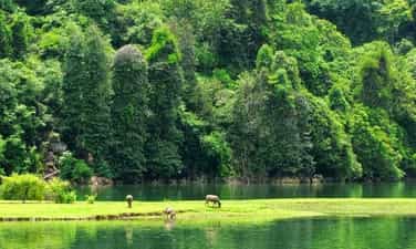
Ba Be National Park is located more than 200 km from Hanoi capital, is an ideal eco-tourism destination for those who love nature and like to explore. Worthy of the title "treasure of Bac Kan mountains and forests", Ba Be garden always makes visitors admire and enchanted every time they have the opportunity to admire it. Coming here, you will be immersed in the wild natural scenery, admire the diverse flora and fauna ecosystem, or more interestingly, enjoy delicious local dishes. Ba Be National Park belongs to Ba Be district, Bac Kan province, stretching across 5 communes of Quang Khe, Khang Ninh, Cao Tri, Cao Thuong and Nam Mau. Dubbed the "treasure of Bac Kan mountains and forests", this place is famous for many beautiful landscapes. Among them, the most prominent is still Ba Be Lake - one of the largest natural freshwater lakes in Vietnam and the world. Ba Be Garden possesses a diverse ecosystem with more than 1,000 plant species and 80 rare animal species. Besides biological diversity, this National Park also attracts visitors with its dreamy beauty that is rare to find anywhere else. Currently, many types of tourism are developing in Ba Be, promising to bring visitors unforgettable experiences. Ba Be Garden is surrounded by primeval forests and rocky mountains, cool all year round. Therefore, the most ideal time for you to travel to Ba Be National Park is in the summer months. If you want to enjoy the bustling festival atmosphere and participate in folk games, you can go in January, around the 9th - 10th day of Tet. A world-famous landscape, Ba Be Garden is both a large biosphere reserve and a flooded Ramsar site on limestone mountains. Coming here, visitors will admire the magnificent cave system, diverse and rare flora and fauna. If you have the opportunity to visit this National Park, do not forget the list of locations including: Puong Cave, Ba Goa Island, Dau Dang Waterfall, Ao Tien, Ba Be Lake, Hua Ma Cave, Tham Phay Cave.
Thai Nguyen
9139 view


Ba Be Lake
Ba Be Lake is a famous eco-tourism area in the Northeast region of Vietnam with many interesting landscapes and biological diversity. Coming to Ba Be Lake, visitors will be immersed in the beautiful natural scenery, enjoy traditional dishes, and discover the unique cultural identity of the ethnic people here... Ba Be Lake is 70km northwest of Bac Kan city, located in the center of Ba Be National Park, in Nam Mau commune, Ba Be district; The Northeast borders Cao Tri and Khang Ninh communes; The Southeast borders Nam Cuong commune and Da Vi commune, Na Hang district, Tuyen Quang province. This is one of the largest natural freshwater lakes in Vietnam. In 1995, Ba Be Lake was recognized by the World Freshwater Lakes Conference held in the US as one of the world's 20 special freshwater lakes that need to be protected. The lake was formed about 200 million years ago due to a major geological upheaval, causing the subsidence of limestone mountains, surrounded by limestone mountains mixed with ancient sandstone and primeval forests. The geology and geomorphology of the Lake area are extremely complex, leading to the formation of breathtakingly beautiful landscapes with unique geological and soil structures, leading to the formation of many different ecosystems. The survey shows a complex mixture of typical Karst ecosystems (a typical weathering phenomenon of limestone mountainous areas eroded by running water) and non-Carst ecosystems in harmony with river and lake ecosystems. Such geological and biological diversity is difficult to encounter in other parts of the world. Ba Be Lake is located in the arc of Gam River, the terrain is rugged and cut by mountains from 1,400m to 1,600m high and interspersed with valleys. The lake is filled with water from two rivers, Cho Leng River and Nam Cuong River, then flows to Nang River, pouring down Dau Dang waterfall. Ba Be Lake is made up of 3 lakes named Pe Leng, Pe Lu and Pe Lam. The lake is more than 08km long, the widest place is 02km, the water surface area is about 500ha, the average depth is 20m, there are places up to 35m deep, there are many species of aquatic animals and freshwater fish living, including many rare and special species recorded in the Vietnam Red Book such as King Carp, Green Bass, Chien fish... Ba Be Lake's water is clear blue, cool all year round, the entire lake is like a watercolor painting. boldly imprinted with mountain silhouettes, covered with clouds and sky, looking like a giant mirror reflecting the winding mountain ranges hidden on the water surface. On the surface of the lake there are many beautiful small islands such as Ba Goa Island, An Ma Island... Around the lake are stilt houses of the Tay people. After a day of walking on the lake, visitors can stop at these places to feel the warm, hospitable life of the villagers. When choosing to rest in the spacious and airy stilt houses, visitors will enjoy traditional dishes of the mountain people, sip a cup of wine fragrant with sticky corn, immerse themselves in zither songs, then tunes, sli, sluon songs, hear the story of Ba Be Lake with the legend of Ba Goa Island, dugout canoes... Ba Be Lake has the majesty of the mountains and forests, and a charm and softness with the water blending with heaven and earth, the surrounding mountains and forests, sometimes moss green, sometimes blue, sometimes mixed with the yellow of the trees, sometimes the white of the clouds... If at some point you need some peace, need quiet, then go to Ba Be. That place will not disappoint you. Ba Be is like a jade amidst the mountains and hills of the Northeast, so fresh, pure and elegant.
Thai Nguyen
9318 view


Thac Lan eco-tourism area
Hac Lan is located 2 km from National Highway No. 2, very convenient for tourists to sightsee and relax after the journey to discover the mystery of Tien Cave. From km 57 of the Tuyen Quang - Ha Giang route, turn left towards the rolling waterfall, visitors have the opportunity to pass through rows of stilt houses that are sometimes hidden and sometimes present, interspersed with primeval forests, where the tail of the waterfall passes through. shiny golden orange gardens. Going deeper into the foot of the waterfall, the majesty of nature makes people feel like they are entering a fairy tale world. Nature cleverly bestows on humans the essence of heaven and earth - the waterfall is like a stream of white silk running through 9 stone steps symbolizing 9 levels of love, so people here call Rolling Waterfall a 9-storey waterfall. or Love waterfall. At Love waterfall, all fatigue disappears, replaced by a pleasant feeling of relaxation. Under the clear blue water are fish with round bodies and long bodies like a shy maiden hiding in mossy rock crevices, above are wild orchid branches hanging down to the water surface. Khuy fish is an extremely rare fish that people here call the god fish. When the morning dawn shines over the top of the waterfall, all kinds of fish, Bamboo fish, crayfish, and stone crabs swim freely and play with people and the mysterious wild natural scenery. It can be said that coming to Lan waterfall to admire the wild beauty of nature. Coming to settle down at the foot of Love Waterfall for over 20 years until today, Mr. Nguyen Van Tiep - A farmer in Thong Nhat Village 3, has fully understood the values that Rolling Waterfall brings to people. Rolling Waterfall is both a natural beauty. However, not only is it a source of irrigation water for fields and in the future, if we know how to properly exploit and use Lan waterfall, it will also be a valuable source of hydroelectricity to serve human life. Rolling Waterfall is one of the attractive eco-tourism destinations that Ham Yen district included in the tourism development program for the period 2006 - 2010. The important issue here is the government party committee and local people of Yen Phu commune. Phu must do better in preservation work such as actively protecting watershed forests to keep the ecological environment clean so that Lan waterfall retains its pristine beauty that nature has bestowed upon it.
Tuyen Quang
5810 view


Thai Hong Pear Flower Garden
In the early morning sunlight, the pear gardens with pure white flowers in Hong Thai commune (Na Hang) are as beautiful as a giant crystal strip, captivating visitors. The warm spring weather is also the time when the pear garden blooms at its fullest and most beautiful. Whether the weather is hazy due to thick fog or clear blue and sunny, being immersed in the beautiful pear gardens in Hong Thai gives us a wonderful feeling that we don't want to leave. In the past, plum trees grew wild in the forest. The fruit was not big, the color was not eye-catching, but it was delicious because of its sour taste, crispy skin and strong sweetness. Thuong Lam girls are charming, gentle, willing to work hard. The natural beauty of Tay girls and their hands to spin cotton, weave fabrics, and embroider brocade have created the age-old cultural beauty of the people here. Surprisingly, the two lands are hundreds of kilometers apart, but the song still brings people and nature closer together. The song makes people more proud and love the nature and people of Tuyen's mountainous region. Plums and pears have existed since ancient times in Hong Thai, a land of many white clouds, many high mountains and several degrees colder than other areas of Tuyen Quang. Residents living on high mountain slopes and farming on terraced fields are mainly Dao Tien people. There are also Mong and Tay people. Their creative and diligent labor from generation to generation has carved a picture of their mountainous homeland. For a long time, plums and pears were just things to eat, entertain guests, and give to relatives and friends. Very rarely is it a commodity product. The tree lives humbly on hillsides or mountain slopes. Spring comes, each tree has its own look, offering the world a season of pure, white flowers. It seems that only when the tree wears new clothes, people are startled to think of the tree, of the cycle of creation. Over the past decade, as tourism has developed, pears and plums have become the highlight of this land. Especially when Hong Thai Terraced Fields was recognized as a National Landscape, pear trees were focused on growing and taking care of people. Pear forests with several hectares of land and hundreds of trees are cared for, pruned, and invested in watering systems. An entire road of pear flowers, up to 6 km long, with nearly 1,000 trees, from Khau Trang village to Na Mu village. Just a few days ago, people planted pears along the winding concrete road, but now pears have bloomed white flowers all over the sky. The tree trunks and branches of pears have white mold and rough patches of symbiotic lichen, and have cracked clusters of beautiful little buds. They huddled, crowded together, sparkling like the silver beams of Dao girls. Thousands of tiny raindrops, resting lightly on thin wings. Clouds and mist like veils also come here to reside. The milky white sky crept lower. They carry moisture to the plant. Under the tree, the grass has just grown green. The white of the flowers, the green of the grass, it seems they are racing with Spring. Many tourists suddenly uttered the poem of the great poet Nguyen Du: "The young green grass creeps up the horizon/The white pear branch is dotted with a few flowers." The end of February and beginning of March is when the weather is in full bloom. Each flower branch, intertwined with each other, resembles a white bridge hanging in the air. On the flower beds, bees were busy searching for honey, accidentally pollinating and bearing fruit for the trees. When the gardener whitewashed each tree stump, the pear tree now looked like a Dao girl wearing white leggings, just stepping out of the Khau Trang fields. Here and there, next to the pear tree are patches of moldy rocks and moss growing around. Standing stones, lying around the base. Strangely enough, the hard, dry thing blends with the pure, clear pear flower. Wandering around the village, we will encounter yin and yang tile roofs. The Dao people's house is spacious and warm like your heart. The houses are close together, at the back of the mountain, at different heights, clustered together into villages. People share the same water source. Water flows from high mountains all year round, gurgling to the village, then distributed to every house. Water to cool garden plants and fields. Pear flowers light up the deep tiled roof, or does the tiled roof make the pear blossoms shine? The costumes of the Dao Tien people are the same, amidst the dark indigo color, the bright spots of silver buttons stand out. As time passed, the pear silently grew, until it was harvested, humble again in its simple brown color. You can go up the mountain slope to explore ancient Shan Tuyet tea trees. The age of the tree is up to a hundred years. To harvest tea, people have to climb trees, vine branches, and pick buds. The outer bark of the tree trunk is white mold. There are trees that I can't wrap my arms around. In cold weather, tea trees have to wear an extra layer of warm clothing, which is a layer of patchy lichen. Tea overcomes cold dew and cold wind, leaving it for buds all year round.
Tuyen Quang
6020 view


