Tourist destination
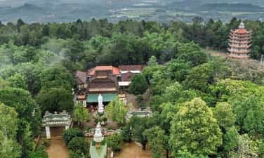
Thien An Mountain
Thien An Mountain has long become a symbol associated with nature and people of Quang Ngai province. This is a tourist destination that should not be missed when arriving in Quang land. Thien An Mountain is also known by another name: Kim An Son or Thien An Niem Ha. This is a mountain located on the left bank of Tra Khuc River, in Tinh An commune, Son Tinh district, about 3.5km from Quang Ngai city. This mountain has a fairly wide and flat top, the four sides are trapezoidal shaped and dense with grass. With a height of up to 100m, Thien An Mountain is like a giant seal lying majestically on the banks of the largest river in Quang Ngai province. Tourists who want to visit Thien An Mountain can start their journey from the intersection of Tra Khuc bridge on National Highway 1A. When you meet Highway 24B, turn east and continue moving for about 5 - 10 minutes to reach the foot of the mountain. The road to Thien An peak is quite easy to go because the slope of the mountain is not high, the road is wide and completely paved. Therefore, most vehicles can get on and off easily. The history of Thien An Mountain is a legend associated with a Zen master named Le Duyet, dharma name Minh Hai, pseudonym Phat Bao, monk Phap Hoa, born in the year Giap Than (1644) of the Lam Te Zen lineage. This Zen master went to Thien An mountain, built a hut and practiced meditation. According to legend, he only ate leaves, wild tubers and drank water from the cave to live. But then the water in the cave ran out, so the Venerable decided to dig a well. With the additional help of a young monk, the monk and his disciples dug a well for three months but with no results. After meditating for 7 days and 7 nights without eating or sleeping, the monk's heart was touched by the Bodhisattva. The Bodhisattva appeared and told him where to look for water. When he found the water source, the young monk also disappeared soon after. To show respect, people named this well Buddha's well because the water from the well never dries up. On the eastern side of Thien An mountain is a pagoda of the same name hidden behind rows of large ancient trees. Thien An Pagoda located right on earth is considered extremely sacred in the minds of Quang Ngai people. This ancient pagoda was built at the end of the 17th century and was given the title "Sac Tu Thien An Pagoda" by Lord Nguyen in 1717. Initially, this place was just a small pagoda, but became more and more attractive. Many monks, nuns and Buddhists choose it as a place to stop. Later, this place became a famous temple on Thien An mountain visited by tourists from all over. In the temple grounds is an ancient well with no bottom. Legend has it that to dig this well, a Zen master had to meditate for 7 days and 7 nights to pray to the Bodhisattva and had to work hard for many months to dig to find the water source. Therefore, this well was named Buddha Well by the people. The surprising thing is that after such a long time, Buddha's Well has never run out of water. In addition, Thien An Pagoda also has a large bell called Chuong Than, brought back from Chu Tuong bronze casting village in 1845 during the reign of King Thieu Tri. In addition, on the east side of the pagoda there is a hexagonal grave area. sense. This is the burial place of the ancestors and abbots of the temple over many generations. The tomb area includes towers built in 5, 7 or 9 floors. Outside are lotus-shaped statues and tombstones recording the merits of the deceased. In particular, at Thien An peak, on the open, flat land to the west, there is also the grave of Mr. Huynh Thuc Khang. This is one of the places not to be missed on your upcoming trip to Quang Ngai. Since ancient times, Thien An Mountain has been considered the "first landscape" of Quang Ngai province. Standing from the top of the mountain, visitors will have the opportunity to admire the panoramic view of the mountains, interspersed with fertile fields and colorful villages, forming a charming landscape picture of Quang Ngai province. . The image of Thien An Mountain and the spiritual pagoda on the top of the mountain demonstrate the strong spiritual attachment to the people here. The two images of Buddha Well and Magic Bell have both entered poetry, associated with unforgettable anecdotes of the people of Quang Ngai. Every year, at Thien An Mountain, the local government organizes many special festivals such as Mr. Huynh's memorial service or religious festivals undertaken by pagodas and believers. This is an occasion when Quang Ngai attracts a large number of tourists to visit, visit the scenery and enjoy the peaceful atmosphere at this famous mountain.
Quang Ngai
4709 view


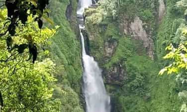
Siu Puong Waterfall
Siu Puong Waterfall is one of the famous places when traveling to Kon Tum that is loved by many young people. The waterfall is located halfway across the Van Peo mountain range in the north, in Dak Na commune (Tu Mo Rong district). Coming to Siu Puong waterfall, in addition to admiring the beauty of the vast and rich mountains and forests, you will also hear mysterious and fascinating stories about the waterfall told by local people here or eat special dishes. only here. Siu Puong Waterfall is also known by the familiar name Da Floor Waterfall. This is a very suitable place for backpacking enthusiasts. The waterfall is located about 42 kilometers from Kon Tum city. To get to the waterfall, you just need to go along Provincial Road 672 about 16 kilometers past the intersection of Dak Tram market, then turn left onto Provincial Road 678 about 30 kilometers more to reach the center of Dak Na commune. From the center, continue traveling for about 20 minutes by motorbike and you can reach the waterfall gate. In order for friends near and far to be able to access the waterfall, many villagers in Dak Na commune have cleared trees, built and expanded walking paths to the waterfall. From the foot of the waterfall, you walk about 1,500 meters to reach the top of the mountain. With many lakes and rich vegetation, Siu Puong waterfall is very suitable for tourist activities of discovery and experience. If the road to Dak Ke waterfall is easy and flat, the road to Siu Puong waterfall will be more winding and winding. However, this will be an experience worth trying for those who are passionate about backpacking and self-sufficient travel. On the way, you will admire the vast terraced fields, with a winding stream flowing through the middle of the fields, looking very poetic. Siu Puong Waterfall is a waterfall that is highly valued by indigenous people. Like the Mang Den pine forest, the waterfall is said to be a spiritual place and has a very sacred water source. People use this water source for daily activities and strictly prohibit activities that pollute the water source such as washing at the source. Menstruating women are not allowed to wade through the waterfall's water, even when burying. People who die in the village are not allowed to carry across this water. However, nowadays the customs and taboos at Siu Puong waterfall have gradually disappeared over time. However, for the Xo Dang people living here, the waterfall's water source still has great significance. The waterfall is about 240 meters long, flowing into many different levels from top to bottom. In particular, there are 5 main floors in a zigzag shape, the top floor is about 60 meters high, 2 floors have an average height of about 40 meters and 2 shorter floors have an average height of about 10 meters. Located at an altitude of 1600 meters above sea level and surrounded by old forests, Siu Puong waterfall always has a cool climate and is especially cold in winter. The water of the waterfall is very clear and cool, suitable for you to relax in the hot summer. However, regardless of the season, when you go to the waterfall, remember to bring a jacket to avoid catching a cold due to the cold water emitted from the waterfall. Not inferior to Yaly waterfall, Siu Puong waterfall with its white water color located between four majestic mountains makes anyone who comes here overwhelmed. All create a magnificent but extremely poetic natural scene, Siu Puong waterfall looks like a soft white silk strip standing out against the green background of the mountains and forests. Besides the beautiful natural scenery, when visiting Siu Puong waterfall you will also have the opportunity to participate in the daily activities of indigenous people such as picking wild vegetables and preparing dishes as a living skill. survive when going to the forest. These will be valuable experiences that bring many interesting emotions to your trip. Another impressive thing is that on the journey to discover Siu Puong waterfall, there will be many stops, some empty fields with beautiful streams flowing through. Like Lo Ba waterfall, you can freely camp and rest on these grounds. When camping and resting right next to the waterfall, you will hear the sounds of the vast mountains and forests, of the gurgling stream flowing through the rapids, bringing a strange feeling of peace. In addition, this place also stands out for its waterfall bathing activities. You can wade and soak in the cool water to refresh your spirit. Coming to Siu Puong waterfall, in addition to discovering the beauty of the waterfall, you can also conquer the vast primeval forest and experience the life of the local people here. You can pick wild vegetables yourself, then boil or grill them with stone snails, stream fish, pork belly,... and enjoy right at the waterfall. Many friends who visit also bring grilled chicken, grilled meat, bamboo-tube rice, wild salt and pepper, bamboo-tube grilled meat combined with wild bananas, etc. when coming here. There is nothing happier than enjoying delicious food while admiring the beautiful scenery and breathing fresh air. However, during the process of lighting a campfire or preparing food, you should pay attention to extinguishing the fire thoroughly to avoid unfortunate events such as forest fires. If you have the opportunity to come to Kon Tum, please try it once. Visit Siu Puong waterfall to admire the beauty of this waterfall with your own eyes. This will be an ideal tourist destination for your summer.
Quang Ngai
5929 view


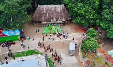
Dak Rang Community Culture - Tourism Village
Dak Rang Community Culture - Tourism Village, an ideal destination for you to experience Gie Trieng culture, explore the nature of the Central Highlands and enjoy moments of peace and relaxation. Community Culture - Tourism Village Dak Rang, located in Dak Rang commune, Ngoc Hoi district, Kon Tum province, is an attractive destination for those who want to explore the uniqueness of Gie Trieng culture and immerse themselves in the wild, majestic nature. With 99% The population is Gie Trieng people, Dak Rang retains all its unique traditional cultural features. Coming here, you will be immersed in a rich cultural space, visit traditional communal houses, learn about brocade weaving, and enjoy typical dishes such as bamboo-tube rice, grilled chicken, and can wine. .. and participate in traditional festivals and rituals such as the new rice celebration, the forest god worship ceremony... The village also has a display house introducing traditional cultural products of 17 ethnic minorities in the area. Ngoc Hoi district, helping visitors better understand the rich cultural and spiritual life of ethnic minorities in the Central Highlands. Dak Rang community tourism village is invested in quite synchronous infrastructure, with electricity systems, clean water, community motels, rest stops, signposts... Visitors can choose to stay at homestay to experience the daily life of the Gie Trieng ethnic people, or participate in nature exploration activities such as trekking, mountain climbing, stream bathing... Come to Dak Rang Culture - Tourism Village, Kon Tum , you will experience the indigenous life of the Gie - Trieng people, immersing yourself in a unique traditional cultural space. Try sleeping one night in a typical stilt house, feel the warmth of an open fire and listen to thrilling stories told by village elders. Early in the morning, wake up to the sound of roosters crowing and join the people in the fields to work, learning how to grow crops and raise livestock in the traditional way. In the afternoon, you can participate in community activities such as brocade weaving, pottery making, knitting... and learn about the unique art of gongs. In the evening, gather around the fire, enjoy specialties such as bamboo-tube rice, grilled chicken, wine... and immerse yourself in traditional music and dance performances, and cultural exchanges with the people. . Let's start by visiting the Rong house, a community center, with unique architecture and sophisticated patterns. Next, you can visit the exhibition house, where artifacts and images introduce the history and culture of the Gie - Trieng people. Don't miss the opportunity to admire colorful traditional costumes, solemnly displayed gongs and learn about exquisite brocade weaving. You can also participate in cultural activities such as gong rituals, a unique cultural feature of the Gie - Trieng people, recognized by UNESCO as an Intangible Cultural Heritage of Humanity, learn how to Weaving, weaving or pottery with local people. In the evening, gathering around the fire, sipping a warm glass of wine and listening to the legendary stories of the Gie - Trieng people will be a memorable experience. From Dak Rang Culture - Tourism Village, you can start your trekking journey to explore the majestic natural landscape of Kon Tum land. Following the trails weaving through the jungle, you will immerse yourself in pristine nature, breathe fresh air and listen to the sounds of the mountains and forests. Along the way, you will encounter gurgling streams, white waterfalls pouring down from cliffs, towering ancient trees and lush green vegetation. Don't forget to bring a camera to capture beautiful moments of nature. If you are lucky, you may encounter wild animals such as monkeys, squirrels, birds... Observe them from a distance and do not disturb their habitat. Trekking in this area is not only a fitness activity but also an opportunity for you to explore the hidden beauty of the Central Highlands mountains and forests and enjoy moments of relaxation and immersion in nature.
Quang Ngai
5800 view


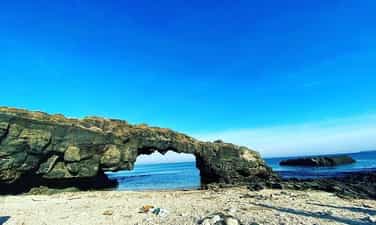
To Vo Archway
The To Vo stone gate landscape located in the west of Lon Island, Ly Son island district (Quang Ngai) is known as a masterpiece of chemistry, with the harmonious beauty of stone, sea and sky. It's called a "gate" but it's actually a natural stone bridge, nearly 8m long, the height depends on the tide level, but is usually about 5-6m (compared to the bridge above), 2.5m -3.5m (compared to the bridge below) at low tide. From field observations and based on stratigraphic comparisons, geologists said that more than 1 million years ago (in the Pleistocene), Gieng Tien volcano had a very strong eruption, called explosive eruption. The lava flow escaping from the volcano covered older sediments (in the late Mio cene), about 5.5 - 6 million years ago. This volcanic eruption is the main cause of the formation of spectacular landscapes around the Gieng Tien mountain area and the west of Big Island. In the sea area of To Vo gate, the lava flow flows into the moving sea water, is condensed by the water flow, followed by the process of landslides and erosion of weak structural parts of the lava block, forming a type of rock. To Vo Stone Gate Bridge is a natural stone as we see today. To Vo Arch is beautiful and famous for its unique shape, standing tall in the middle of an airy natural landscape. Each block of stone is solid and angular, but when connected together, it forms a stone gate with a soft, flexible shaping rhythm and can display beauty in all angles of space, as well as at any time. any day, even on moonlit nights or when the sky is filled with starlight. Early in the morning, the sun slowly appeared, the first sunlight of the day was like the hand of the goddess Rang Dong spreading high into the sky to play with the wings of seagulls gliding in the air. At noon, soccer ball cages water balloons; waves wavering; suddenly disappear, suddenly appear; like yes, like no. When sunset falls, from the rocky beach, looking through the arch of the gate, there are glimpses of fishermen's fishing boats slowly returning to the wharf to rest for the night in the whisper of the waves and wind in the distance. But the interesting thing is when climbing to the roof of the stone gate to heaven. Looking to the East is a fishing village like a painting of undulating water waves. Slightly to the north is Gieng Tien cliff with Duc pagoda. In the distance is Be Island, with looming coconut shadows, a Dun island emerges as if to remind that there is Bo Bai Island, Be An Binh Island, as beautiful as a poem. Further away, pointing directly to the west, is the mainland, the ancestral homeland of the island clans, with Tong Binh cape reminiscent of the heart-wrenching folk song: The clear sky saw the General Binh Ask if your old friend remembers you or not? In the midst of heaven and earth, suddenly I want to press my small human feet down on a block of lava that has been extinguished since ancient times, then raise my eyes to look up into the abyss and recognize the flashes of light from far away in the universe. Is it possible that the stone dome that is wrapping its arms around the sea can hold its natural essence with us in the midst of a beginningless, endless stream of time? Eastern people believe that every existence in this world has a symmetrical existence. There is day and there is night. There is an Evening star so there is a Morning star (later science showed that the Evening star and the Morning star are just one, which is Venus). There is light playing on the top of the mountain and there is also twilight darkness under the bridge. But with To Vo stone gate, that symmetrical existence is surprising. On this side, Lon Island, there is To Vo gate rising high, basking in the moon and moon, on the other side, on Be An Binh island, there is also a To Vo gate soaking in the water bottom. Also from volcanic eruptions, also solidified lava. Coming to Ly Son, take the time to admire the magical landscape of To Vo gate, a natural stone bridge between heaven and earth on the Big Island. Wait until the spring equinox, when the sea water becomes warm, take a scuba diving trip to see the colorful coral reefs, to see To Vo gate shimmering in the sea water on Bo Bai island (another name for the island). Baby) will be extremely interesting. Visiting To Vo stone gate is an experience not to be missed when coming to Ly Son. This is not only an attractive tourist destination because of its natural beauty, but also gives visitors the opportunity to learn about geological structures, tectonic history along with magical mysteries hidden for millions of years in each region. stone veins.
Quang Ngai
5328 view


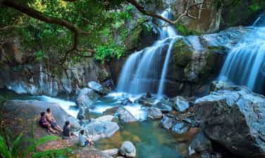
Lung O Waterfall
Quang Ngai tourism attracts tourists by its poetic and majestic landscapes. Among them, Lung O waterfall is a place that many people come to enjoy the fresh, peaceful space after stressful days of work and study. Lung O waterfall is located in Ba Thanh commune, Ba To district, Quang Ngai, about 15km from National Highway 1A and 45km from the city center. As soon as you reach the edge of the forest, you can hear the sound of flowing water, urging you to admire the wonderful beauty of Lung O waterfall. Coming to this Quang Ngai tourist destination, visitors will certainly feel surprised by the wild and majestic natural scenery. The water flows down from above like a soft silk strip across the endless green mountains and forests, creating an extremely eye-catching landscape painting. Here, you will admire the image of a waterfall flowing with white foam, and at the same time relax in the fresh space. At the foot of Lung O waterfall is a lake about 200m2 wide with emerald green water. At the foot of Lung O waterfall in Quang Ngai, there is a lake about 200m² wide with beautiful jade green color. The lake is surrounded by large rocks, creating an ideal space for visitors to relax and refresh their spirits after stressful working days. You can enjoy the feeling of soaking in the cool water of the lake, while listening to the singing of the mountains and forests. Surely, this experience will make you want to come back here again and again. In addition to admiring the scenery and bathing in the stream, visitors can also participate in a number of interesting activities at Lung O waterfall such as camping on large rocks on the banks of the stream, rolling up their pants and wading in the stream to catch fish, or even Stand on a high rock to jump into the lake or climb a mountain to reach the waterfall. Don't forget to take check-in photos with the majestic waterfall to capture memorable memories. Surrounding the lake are large rocks. This is the ideal place for visitors to shake off all worries and "reset" themselves after a series of stressful and tiring working days. Not only that, you can also immerse yourself in the cool water of the lake. The feeling of soaking in the clear water while listening to the joyful song of the mountains and forests will definitely make you come back here again and again. After having fun at Lung O waterfall, visitors should not forget to enjoy Quang Ngai specialties such as grilled beef with lolot leaves, grilled fish with onion fat... In particular, grilled tilapia fish with onion fat and dipped in the signature dipping sauce is a delicious dish for you. definitely must try. To fully enjoy the chill feeling, visitors should order a few dishes and buy some drinks and go to the rocky shore next to the waterfall to enjoy. Revealing that the cool water is a magical "refrigerator" for you to soak fruits and drinks. However, the path to the waterfall is quite narrow, so you should ride a motorbike to easily move and save time. If you intend to organize a picnic by the stream, prepare food, water and a mat in advance to enjoy a comfortable and convenient picnic. When visiting, wear comfortable clothing and sneakers with good traction. This will help you move easily on difficult terrain and avoid the risk of slipping. Don't forget to prepare insect repellent and wound dressings. They will help you prevent insect-related problems and treat minor injuries if any. When cooking, find a well-ventilated place with no leaves nearby to avoid the risk of causing a forest fire. Ensure safety for everyone around and protect the environment around the waterfall. With its wild and majestic beauty, Lung O Waterfall in Quang Ngai has attracted many tourists to visit and explore. This is one of the great destinations to get away from the stresses of modern life and enjoy peaceful moments in nature. Let's come to Lung O Waterfall in Quang Ngai and discover its beauty.
Quang Ngai
5598 view


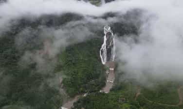
White Waterfall Ecotourism Area
Quang Ngai has long attracted a large number of tourists every year because it not only possesses a fresh, cool atmosphere but also contains extremely unique tourist attractions. Among famous places in Quang Ngai such as Ly Son island, the appearance of Minh Long White Waterfall is also an equally attractive place attracting tourists as well as local people to visit. White Waterfall Minh Long is located about 36km from Quang Ngai city center. If you go from the city center, you will go southwest, starting from Chua market town in Nghia Hanh district to go along the small pass towards Minh Long district. After arriving in Minh Long district, you continue to move straight for another 5km to see a sign pointing to Minh Long White Waterfall. Minh Long White Waterfall is located in Thach An commune, Minh Long district, Quang Ngai province. This place possesses the most outstanding natural scenery, the white waterfall about 40m high flowing from top to bottom parallel to the two sides of the lake below, surrounded by a layer of green of rolling hills and mountains. a poetic, charming natural picture. In addition, at the foot of Minh Long White Waterfall are two large lakes with a clear blue color, suitable for you to take a dip in this water stream to relax and breathe in the fresh air of the green forest. away from the hot weather in the crowded and bustling city. Minh Long White Waterfall is one of the few places that inherits the natural beauty from the land of Quang Ngai with the blend of green trees of the forest and majestic high hills and mountains creating a natural picture. fresh, green and cool. The most prominent highlight of this tourist area is the white waterfall flowing strongly depending on the different seasons along with the clear blue water surface, giving tourists relaxing vacations by soaking in the water and immersing themselves in the beauty of nature. The fresh air of nature, away from all pressures in life. In addition, Minh Long White Waterfall is also a place where you can easily take extremely chill check-in photos at the waterfall because the place is full of colors. The greenness of the forest trees along with the whiteness of the waterfall promises to bring you beautiful, perfect, one-of-a-kind photos. Coming to Minh Long White Waterfall, you can not only admire the beauty of the waterfall along with surrounding scenery but you can also do interesting activities here. Outstanding activities include camping overnight, singing and dancing, and making outdoor BBQs next to the vacant lots at the foot of the waterfall. This helps you to immerse yourself in the natural scenery at the foot of the waterfall, enjoy relaxing moments by the lake as well as find yourself serenity and peace away from the hustle and bustle of life in the city. In addition, another outstanding place at Minh Long White Waterfall that can be visited, suitable for those who are passionate about exploring nature, is the primeval forest and villages of the Hre ethnic group. This place not only allows you to discover more natural beauty, but you also understand more about the unique culture and human beauty of the Hre ethnic group here. Minh Long White Waterfall is one of the few places that possesses poetic and lyrical natural scenery of majestic mountains and forests and rows of green trees, but also contains a fresh, cool atmosphere that will make you relax. You somehow forget the fatigue and worries in the hustle and bustle of life. And besides admiring the natural beauty, you will discover more about the national cultural identity of the local people here to understand more about the beauty of the people of the South Coast region. Central region. If you have the opportunity to visit Quang Ngai, try setting foot at Minh Long White Waterfall to discover firsthand the beauty of this place as well as experience interesting activities next to the waterfall that will surely stay in your mind. your mind with memorable memories.
Quang Ngai
5749 view


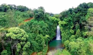
Pa Sy Waterfall
Pa Sy Waterfall is a prominent landmark in the romantic Mang Den land, associated with the legend "Seven lakes, three waterfalls" a story of the Mo Nam ethnic people, when in the past, violating heaven's prohibition, all 7 villages were punished. sink into a sea of flames. Later it turned into 7 lakes and 3 waterfalls. Among the three majestic waterfalls, Pa Sy waterfall is the largest waterfall in the region. The name Pa Sy was born due to a deviation from the original name of the Pau Suh people, meaning "three streams gathered together". With two distinct seasons: the rainy season and the dry season, you should choose the appropriate time to visit the waterfall. According to experience traveling to Pa Sy waterfall, the dry season around October to April of the following year is the ideal time. ideal to visit the majestic waterfall. At this time, the dry weather is favorable for traveling, participating in outdoor activities and participating in festivals. This is also the season when ripe rice blooms and turns golden in all corners of the road near the waterfall. Coming to the waterfall in the dry season, you will admire the majesty of the waterfall. At this time, the clear blue water creates a truly lyrical scene. In the dry and hot dry season, coming to the waterfall area will cool you down, giving you a very pleasant feeling. Pa Sy Waterfall is located in the Pa Sy Waterfall cultural eco-tourism area, located in Mang Canh commune, Kon Plong district, Kon Tum province. With a total area of up to 25 hectares, the tourist area stands out with the green of nature, like a giant garden of Eden. To get to the waterfall, you can choose a bus or plane to travel. If you feel suffocated with current life and want to find a peaceful place to relax, gather with friends, relatives and have fun to recharge new energy, then Pa Sy waterfall eco-tourism area would be a reasonable choice. It only costs you less than 100,000 VND/person to have fun here. Pa Sy waterfall in Kon Tum is famous for its water flowing from a height of more than 1,500m with white foam, both majestic beauty and poetic and rustic features. The turquoise waterfall and lake are surrounded by majestic primeval mountains and forests, creating a fresh water picture like a fairyland. On hot summer days, the cool waterfall will help relieve the heat, wash the soul, and help visitors enjoy the most relaxing and comfortable feeling. In the lush natural scenery, dotted by a white waterfall like a silk strip across the sky, coming here you will take many beautiful photos. Let's make memories with friends and relatives at this fairyland. In addition, visitors can also participate in the special festivals of the Ro Mam people held annually such as the Rice Sowing Festival, new rice celebration, the buffalo barn worshiping festival, burial customs,... So Be sure to find out the festival time before arriving. Coming to the tourist area, you will not only admire the beautiful scenery at the waterfall, but this is also an opportunity for you to enjoy delicious Central Highlands specialties. It's great to rent a tent with friends to hold an outdoor BBQ party, enjoy coffee and watch the mountains and hills, amidst the majestic landscape, with a few scattered roofs and stilt houses appearing under the garden. Coming to the Pa Sy waterfall cultural eco-tourism area, visitors also have the opportunity to admire 100 wooden statues, vividly showing the daily lives of people here, and is also an opportunity for you to understand more about national culture. A few notes below will help make your visit to Pa Sy waterfall more complete. Plan your trip early to have the most complete arrangements and preparations. To be proactive in transportation, motorbikes are the preferred means of choice. You can easily rent motorbikes in the Mang Den or Kon Tum area for 120,000 VND/day. Experience renting a house in the form of a homestay, to enjoy a poetic space, and learn more about the lives of the people here. Combine tourism at locations near Pa Sy waterfall such as Dambri lake, Khanh Lam pagoda,...
Quang Ngai
6320 view


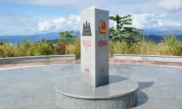
Indochina Junction
The place of the Indochina junction on the majestic Truong Son range has always been in the memories of soldiers and young volunteers on their way to the Southern battlefield, battlefield C (Laos), battlefield K (Cambodia) over the years. Unforgettable war. This is the land known as the rooster crowing that all three countries hear together. Now this land is becoming one of the attractive tourist destinations for domestic and foreign tourists. Places where places have gone down in history such as the Indochina junction (where Truong Son West road meets Truong Son East road during the resistance war), historical relics of the victory of Dak To - Tan Canh in April 1972; The border marker was jointly built by the three brother countries Vietnam - Laos - Cambodia on a mountain top 1,000m above sea level, about 30km from Playku town. This milestone was constructed by Kon Tum province in December 2007 under the supervision of experts from three countries sharing a common border. Representatives of the three countries' Ministries of Foreign Affairs held a solemn inauguration ceremony on January 18, 2008. The special milestone weighs 900 kg, is made of triangular cylindrical marble, is 2 meters high, and on each side of the milestone facing each country is attached the national emblem, the year the milestone was installed and the country's name in red letters of the government. that country. This is the second milestone marking all three countries to be placed on Vietnamese soil. The first milestone is the unified construction of the three countries Vietnam - Laos - China in A Pa Chai (Dien Bien).
Quang Ngai
6106 view


Ngoc Linh Mountain
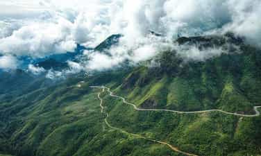
Stretching across the four provinces of Kon Tum, Quang Nam, Quang Ngai and Gia Lai, Ngoc Linh Mountain, also known as Ngoc Linh Lien Son, is one of the highest and most massive mountain blocks in the Truong Son range next to its brothers. such as Ngoc Phan Mountain, Muong Hoong Peak, Ngoc Lum Heo or Ngoc Bon Son. The stopping place is covered by a layer of magical white clouds with the legendary Dak Bla River running across, making everyone watching from a distance unable to help but be captivated by the majestic natural beauty. As a sacred mountain located in a sacred land of convergence, Ngoc Linh attracts millions of visits every year, of which the most prominent is certainly the adventurous conquering of skyscraper peaks. Although Kon Tum's climate is cool all year round, in general the best time to check-in to Ngoc Linh Mountain is from December to March of the following year, when the weather is fresh, airy, sunny and extremely sunny. rain. Because the trekking route is particularly steep and dangerous, this is a prerequisite with an experienced guide and professional climbing support tools to start the journey to discover Ngoc Linh Lien Son. You can visit in the last two months of the year, December and November, to watch wild sunflowers bloom brightly during the trip or enjoy the scenery of rubber forests in the changing season of leaves in January, coffee hills with small flowers. Tiny, pure white brightens up the entire sky in March. All of them promise to bring you memorable travel moments. Ngoc Linh Lien Son block is located adjacent to Quang Nam and Kon Tum, so in general, travelers starting from Saigon who want to go to this place can stop at one of the two provinces mentioned above with a variety of means of transport such as Plane, bus, limousine... Normally, a bus from Ho Chi Minh City to Kon Tum will cost from 200,000 VND to 300,000 VND/one-way route, however the journey takes quite a long time (nearly 14 hours). You can consider booking a limousine ticket from Phong Phu, Tan Anh or Truong Giang with the expected cost of about 400,000 VND to 600,000 VND/one-way trip if you want a comfortable and convenient long-distance travel experience. most suspicious. This is also a type that is very popular with friends near and far when they have the opportunity to travel to Kon Tum. After arriving at these two provinces, the traveling association just needs to take a taxi or rent a car or motorbike to get to Ngoc Linh Mountain. For you to stop in Kon Tum, here is the easiest and most popular backpacking route to the mountain that you can refer to: From the center of the mountain town, people follow National Highway 14 to DT672 road. belongs to Tu Mo Rong district. After going towards DT673 about 34km, you will be greeted by Ngoc Linh Nature Reserve - where Ngoc Linh Lien Son is located. Although the whole journey may take about 2 hours to travel, in return you will have many opportunities to admire and explore impressive scenery. Among the interesting activities here such as visiting Chu Mom Ray National Park, exploring Mang Den Pine Forest, perhaps conquering Ngoc Linh Mountain is an extremely attractive experience when having the opportunity to visit the land of Kon Tum. this spirit. With a height of more than 2,500 meters above sea level, to climb the mountain you must first start from small, winding roads that are difficult to get to the cliffs and extremely dangerous cliffs. Next is to cross the streams of water flowing through the rocks creating a gurgling sound imbued with the majestic nature and cross the primeval forests stretching for kilometers with a variety of rare and hard-to-find creatures. With every step you take to explore, the wild landscape that appears here will make you curious and excited. The most memorable is definitely the feeling of walking through the walls of leaves that seem to be silently covering and protecting this sacred mountain while opening the way upward. The air is cool at first, then gets colder and colder, showing that the traveler is getting closer to the clouds floating on Ngoc Linh peak - the place where many mysteries are hidden. It is the rugged roads, dangerous green forests and countless fast-flowing streams that create a welcome challenge for adventure enthusiasts when setting foot on this mountain.
Quang Ngai
6743 view


Chu Mom Ray National Park
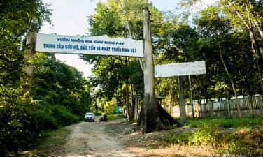
Coming to Kon Tum, don't forget to visit Chu Mom Ray National Park where there is a rare and diverse ecosystem of flora and fauna. This place is probably one of the interesting places to visit that helps visitors have experiences close to nature. At the same time, you can also explore the beautiful scenes of "mother nature" and learn more about the extremely diverse ecosystem here. Not only that, visitors can also learn about the cultural identity and cuisine of the indigenous people of this great Central Highlands region. Chu Mom Ray National Park is located in the North of the Central Highlands in Kon Tum Province. This is considered a transnational biological reserve because it borders both Laos and Cambodia. The West borders Virachey National Park of Cambodia and the Northwest borders the Southeast Ghong Conservation Area of Laos, which is the touch point of three countries, so many people call it a transnational conservation area. The area of this entire area is estimated to be up to 700,000 hectares with a diverse biological system, so it is of special importance to the biological conservation of Indochina in general and Southeast Asia in particular. With a rich and diverse biological system, in 2004 Chu Mom Ray National Park was recognized as an ASEAN heritage by the Association of Southeast Asian Nations. From May to November, this time it rains often, the roads are slippery and difficult to move. On the contrary, in the dry season, the weather is cool and the roads are easy to travel, especially in February and March, when wildflowers bloom on extremely beautiful roads. On this occasion, there are also many festivals of indigenous people taking place, so perhaps coming on this occasion you will have the most complete journey possible. Chu Mom Ray National Park not only has an extremely diverse ecological system, vast mountains and forests, interspersed with numerous systems of rivers, streams, and waterfalls. Perhaps that is why more and more people come to visit, explore, immerse themselves in nature and enjoy the mountain atmosphere. Ja Book Valley is located deep in the "old forest" and has an area of up to 16,000 hectares. Previously, this place was a vast green grassland, a place where many species came to find food and shelter such as Indochinese Tiger, Gaur, Wild Buffalo, Wild Boar,... but now there are only about 6 hectares of grassland, the rest is heavily invaded by a type of thorn bush. Compared to before, the number of animals residing here has decreased significantly. Visiting here, visitors can see wild animals such as wild boar, wild buffalo... coming in search of food and water. Chu Mom Ray National Park includes many types of terrain, hills, valleys,... so there are many interlaced systems of streams, thus creating conditions for the formation of magnificent waterfalls. The 7-storey waterfall is a famous landmark located within the Chu Mom Ray National Park campus. The flow from the top of the waterfall, dozens of meters high, flows down step by step, creating an extremely impressive and eye-catching scene for onlookers. The lush green mountain scenery mixed with the rolling waterfall seems to create a masterpiece of nature, an extremely vivid mountain and water painting. Chu Mom Ray National Park is home to a number of ethnic minorities such as: Ro Mam, Ba Goc, Bo Rau, H Lang, Gia Rai, Ko Dong,... including the Bo Rau ethnic group. the smallest ethnic group among the 54 ethnic groups. Visiting villages of ethnic minorities, people also have the opportunity to experience and learn more about the unique culture of the indigenous people. In addition, you can also enjoy specialties made by indigenous people, and rest in communal houses or public houses of the people here. If you have the opportunity for a long trip, choose a suitable itinerary to visit Chu Mom Ray National Park and visit many places in Kon Tum. Some suggested places for tourists to refer to include: Yaly Waterfall, Ho Chi Minh Trail, Bo Y international border gate, Kon Klor Communal House, T'Nung Lake,...
Quang Ngai
6240 view


