Relic point Vietnam
Việt Nam
Elephant Waterfall (Lieng Rooa Waterfall)
Lieng Rowoa waterfall, also known as Voi Waterfall, is located in Nam Ban town, Lam Ha district, 25km southwest of Dalat city. Elephant Waterfall is one of the beautiful waterfalls of the majestic Central Highlands with a height of over 30m and about 15m wide. The old K'Ho villages residing in this land said: In the past, the chief of Jiu Bieng Mountain had a very beautiful daughter. Every time the female painted the voice, the forest leaves stop rustling, the birds stopped singing to listen. Her lover is the son of the chief of the village. He is loved by many people, not only because of his muscular physique, handsome face but also because of the bravery, brave, few people can match. They gave the promise so the husband and wife, but the boy had to set out to kill the enemy and then many moon seasons passed without seeing returning. The miserable girl came to the deserted mountain that they had dated before, singing earnestly and sorrowfully in the hope that the dream people to find the old place. The singing makes B'Ling birds touched. They invited each other to fly far away to detect the news and then let her know that the boy died on the battlefield. However, Son Nu still refused to accept that harsh truth. She kept singing, singing until she was exhausted, collapsed and never got up again. The elephant -covered herd listened to her singing for a long time. Suddenly there was a loud explosion, the sky and earth shook, causing the mountain to break and a stream of waterfall suddenly flowing, flowing white foam. The sound of the waterfall murmur and the rustling of the forest, the sound of the birds singing like continuing the lyrics, the sound of the beautiful and loyal female paint. The K'Ho people named the Waterfall Lieng Lieng Rooa Jiên Bieng - the waterfall of the elephants to restore stone before the passionate love, iron lipstick. It will be a pity to come to Da Lat - Lam Dong without going to Lieng Rooa (Voi Voi) mysterious and poetic. This waterfall is associated with this loyal and tragic love affair has been recognized as a national landscape. The clear water flowed through the marble mountainside to look spectacular, especially when the brilliant sunlight shone down the waterfall, making the rainbow seven colors. To get down the foot of the waterfall, visitors must "conquer" 145 steps of the races: When the stone steps "eat" into the climbing cliffs, when the planks of the beautiful wooden bridge are on the edge of the abyss. The sight is the thousands of forest with the old trees hundreds of years old, the stems and branches are interlaced with vines. In the middle of the vast gills, the green forest layer or dotted with bright red leaves like fire, bright yellow or purple carpets are strangely beautiful. At the foot of the waterfall and in the forest, some large rocks appeared like elephants. Therefore, the sound of the waterfall that made people enjoy it seemed like there was a herd of elephants racing or launching a fountain to play with each other. Behind the white waterfall is launching the dusty dust are deep caves full of mysteries. It is a bat cave that is ingrained to the ground up to 50m with cliffs with very strange shapes and colors. The roots and vines are interwoven, the deeper the cave is thanks to and cold as the witch's dynamic. It was a wind cave with a very narrow entrance but the inside was quite wide, soaring the flute of the wind. Besides the charming and poetic beauty, Voi Thac used to be revolutionary in the two wars against France - America. Newly embellished into tourist attractions in recent years. In 2001, Voi Waterfall was recognized as a national monument - a national landscape. Source of the electronic portal of Lam Dong province.
Lam Dong
4706 view
Rating : National relics.

Da Thien Lake - Valley of Love
Love Valley is one of the most poetic landscapes in Da Lat, about 5 km north of the city center, the Valley of Love has the address at 7 Mai Anh Dao, Ward 8, Da Lat City. It is the place where Da Thien Dam brings together small streams flowing from high hills and mountains, the clear and clear lake of the valley is shaded with green pine. In the 1930s, Governor -General of Indochina and French lovers often chose this scene for dating, then named Valleé D'Amour. By the time of King Bao Dai, this region was called Hoa Binh valley. In 1953, Mr. Nguyen Vy - Chairman of Da Lat Town Council at that time - proposed to change his name to the Valley of Love. Beautiful and attractive love valley by deep valley and pine hill all year round. In 1972, a block of water was built across the valley to form Da Thien Lake, increasing the charm of the common landscape, and appearing two other names besides the valley of love, Dam 3 and Da Thien 3. From here, the valley of love appears in a beautiful eye like a vivid picture. In 1998, the Ministry of Culture and Information recognized Ho Da Thien - Valley of Love was a national landscape. Source of electronic portal of Da Lat city, Lam Dong province.
Lam Dong
4586 view
Rating : National relics.
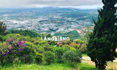
Lang Bian Mountain
Lang Bian Mountain is located in Lac Duong district, 12km north of Dalat city center. This is a suitable place for ethnologists, for tourists who love traditional culture to cultural research of the ethnic groups of the South Central Highlands. Lang Bian Mountain is also known as Mother Mountain, including 2 tops, with an altitude of 2,167m. The old story said that there was a couple of talented and loving boys and girls in love with each other - K'Lang and her Ho Bian. Due to the curse of the two tribes, the two had to separate. She after death transformed into a mountain range that the Ho-Lach ethnic group called the mother mountain and milk from her breasts has flows into the fresh streams and waterfalls for life. Since then, the two mountains have been named Lang Bian. Lang Biang Mountain, also known as Ba Mountain with a height of 2,189m of the legendary Bidoup series, has long become a regular destination for visitors. Langbiang mountain is also famous for its legend associated with the history of the indigenous people about the famous Heavenly History of Lang and Biang. Since 2004, the Ministry of Culture and Information has recognized Lang Biang as a national landscape monument. Source Department of Culture, Sports and Tourism of Lam Dong Province
Lam Dong
4915 view
Rating : National relics.

Prenn waterfall
Prenn Waterfall is a waterfall in Da Lat city in Lam Dong province. Prenn Waterfall is located next to Highway 20, at the gateway to Dalat city is one of the eco -tourism areas of forests and streams. Waterfall at the foot of Prenn pass is about 10 km from the center of Dalat. The waterfall is located in the remaining primeval forest. The water from the rocky rapids with a height of more than 20m high poured into white like a strip of white silk looks like the hair of the White Mao Tien. Maybe so that some tourists call Tien Sa waterfall. Prenn waterfall originates from Prenn stream, originating from the area of shrimp pit, Bao Dai stream (valley after palace 1 - Da Lat). Prenn stream is also known as the Prenn and Prenn Waterfall, also known as Liang Tarding. Coming to Prenn Waterfall, visitors can visit, entertain and visit Au Lac temple, King Hung temple in Lam Dong province. The legend of Prenn Waterfall is also associated with the development history of the Cham dynasty in the seventeenth century of the Poôme dynasty (1625 - 1651). Since 1998, Prenn Waterfall has been ranked by the Ministry of Culture and Information. Source Department of Culture, Sports and Tourism of Lam Dong Province
Lam Dong
4803 view
Rating : National relics.

Cat Tien archaeological monument
Cat Tien Archaeological Site is a complex of brick architectural ruins with a very large scale, stretching about 15km according to Ta Ngan Dong Nai River from Quang Ngai commune to Duc Pho and Gia Vien communes (Cat Tien district - Lam Dong province). Archaeological excavation results (from 1994 to 2006) many architectural ruins of temple tower, tomb, long house, water trough system, ancient rocky roads, ... have been revealed. The architecture here is large and small, depending on the function, with square or rectangular plots, the main door turned to the east. The excavation process has found more than 1,000 artifacts including many materials such as gold, silver, copper, gemstone, ceramic, ... rich in type such as: idol Linga - Yoni, Ganesa, UMA god, rings, chain seeds, floating gold leaves of the gods, Balamon mascots. Through the type of architecture, the artifact is found that this is a religious mecca influencing the Indian religion and the trace of a unique culture in the past. Cat Tien Archaeological Relic is a big finding of Vietnamese archeology in the late twentieth century, which is important in studying ancient cultures in the South and the Central Highlands. Archaeological excavations show that Cat Tien culture has a fairly long development process: the early period around the fourth century - VI and the late period of the Seventh - 10th century AD. Especially, the development process of Cat Tien culture has a close relationship with the Champa culture in the South Central Coast and Oc Eo - Oc Eo culture of the Southern Delta of Vietnam. In the opinion of the late Professor Tran Quoc Vuong in the scientific conference of Cat Tien archaeological monument, (March 2001) concluded: “This relic has many unique native elements (endogenous) and also has many external factors (external - exogenous). The external factors saw from the southwest are Chan Lap and from the Northeast is Champa, including physical and formless culture. It is possible that the cultural elements are slightly inclined to Chan Lap and the inhuman elements are inclined to the Champa. Therefore, this monument is "standing between and it is itself". Cat Tien archaeological relic is located in the middle of the provincial road 721 connecting Highway 20 (Madagui junction - Domhuoai district - Lam Dong province) with Highway 14 (Sao Bung junction - Bu Dang district - Binh Phuoc province). The relic center is located on the north bank of Dong Nai River close to the core area of Cat Tien National Park, about 190km from Da Lat (north) and Ho Chi Minh City. Ho Chi Minh City is about 180km (south), this is a pretty location on the tourism map, very convenient for tours from Ho Chi Minh City, Da Lat and the Central Highlands provinces to visit. Cat Tien Archaeological Relic is also known as the Holy Land of Cat Tien, which preserves the evidence of a unique culture more than 1,000 years ago. With the wide scene of the monument and a rich number of artifacts and special values such as the floating yellow leaves shaped by the gods, the Balamon religion and the collection of Linga - Yoni of gold, copper, stone, gemstones ... including the giant Linga - Yoni idol is identified as the largest in Southeast Asia (compared to the relics of the same quality). In addition to the Cat Tien archaeological site in Cat Tien district, visitors can also visit the historical and resistance relics of the Party Committee of the Vi area and some living points of the Ma people and the long -standing indigenous people who have been living on this legendary land. Cat Tien Archaeological Archaeological Area bears the indigenous culture, but still shows the absorption of the quintessence of other cultures throughout the historical length from the fourth century to IX. It is associated with an organized and large -scale ancient community, with a unified and tight socio -economic system with high levels of development (the most convincing evidence is the appearance of writing on golden pieces). The formation and development of the monument plays an important role in the historical process of the South Central Highlands - Southeast. With a special special value, Cat Tien archaeological monument (Cat Tien district, Lam Dong province) was ranked as a special national monument by the Prime Minister (in Decision No. 2408/Decision -Prime Minister dated December 31, 2014) Source of cultural heritage.
Lam Dong
4790 view
Rating : Special national relics.
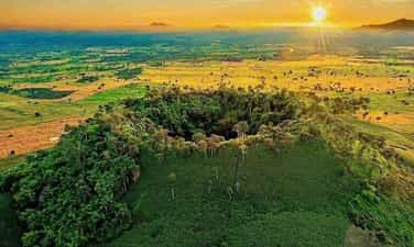
B’lang volcanic landscape
B’lang volcano (also known as Chu R’luh volcano), in Buon Choah commune and Nam Da commune. This is a volcano formed in the final stage of Geological Development History - Global Geological Park (CVDCC) UNESCO Dak Nong. This is the only volcano in Dak Nong Geological Park to create the lava cave system, the most large and unique in Southeast Asia. According to the survey, research by scientists, the process of operating lava lines from the b’lang crater flows in all different directions (Northwest, Northeast, Southwest and Southeast). Up to now, 4 cave systems have been detected, including 50 caves with distribution characteristics and mechanisms to form a cave, rich and diverse cave doors and beautiful. There are many caves distributed in the shallow floor, but there are also many cave distributed in the deep floor tens of meters. B’lang volcano, distributed at an altitude of about 601m above sea level with a depth of the crater is about 59m. The mountain axis is about 160m long, short axis about 100m; The crater area is about 4 hectares, the volcano area is about 1.6 km2. B’lang volcano area is located near carbon, rich in cultural traditions of the M’nong and Ede ethnic groups ... With traditional festivals, professions and cultural and scenic historical sites, the ranking has been ranked favorable to connect tours, tourism routes, exploit and develop tourism in the future. On March 12, 2024, the Ministry of Culture and Sports -Lich issued Decision No. 611 of the national monument ranking for B’Lang volcanic landscape, Buon Choah commune and Nam Da commune. Source of electronic portal of Krong No district, Dak Nong province.
Lam Dong
5069 view
Rating : National relics.
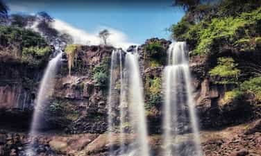
Drai Dlong Waterfall
Drai Dlong waterfall is 35 km from the center of Buon Ma Thuot city, in Quang Hiep and Ea M’Drŏh communes, Cu M’gar district, Dak Lak province. Drai in Ede means waterfall; Dlong means high, so Drai Dlong means high waterfall. In addition, this landscape is also known as a three -storey waterfall. Located in the southwest of Quang Hiep commune, made up of two hills covered with an average height of 500m above sea level, the flow of Drai Dlong waterfall originates from the flow of two Ea’Drǒh streams (big streams) and Ea M’Drǎh stream (small stream), to the section near the waterfall about 01 km, blend into each other, meet large rocks, divide and divide the height of 30m to block the height of three branches. The white silk strip from above poured down. From the bottom to look up, the great waterfall, sparkling with silver, surrounded by good green forests with rising trees to adapt to the vertical cliff terrain, there are many rare timber trees such as stars, incense, chit, purple mausoleum, especially cactus growing on rocks. About 01 km from Drai Dlong Waterfall is M’Drŏh (Buon Chay), this is the trading of Ede people. During the years of resistance against the US, M’Drŏh traders, along with forest merchants, traders, Ea Win merchants transported food to the resistance from the A10-B3 station via Ea H’Leo, Krong Bong and to Phu Yen, Khanh Hoa. Buon M’Drǒh is a base of H5, the people in the village have persisted in fighting, organizing patrols to guard, bringing, raising revolutionary officials, bustling, trapping and manufacturing rudimentary weapons to protect the village. During the fierce war, the enemy organized a sweeping, persecuted, brutally beaten, but the people of M’Drǒh from the old, young, boys and girls would rather be beaten, hungry rice, but not to cooperate with the enemy, a heart of the Party to the end. When the enemy discovered that this was a facility that hid revolutionary officials, even M’Drǒh was burned and no longer had any home, so the merchant was also known as the fire. On December 15, 2004, the Ministry of Culture, Sports and Tourism ranked Drai Dlong waterfall as a national landscape monument. Source of electronic portal in Dak Lak province.
Dak Lak
4749 view
Rating : National relics.
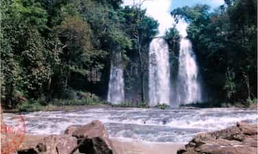
Drai Yong Waterfall
Drai Yong Waterfall is located in Ea M’nang commune, Cu Mgar district and Cuo Knia commune, Buon Don district, 22 km from the center of Buon Ma Thuot city to the Northwest. Drai Yong Waterfall was ranked National Monuments in Decision No. 823/Decision -The Culture and Sports Culture on March 9, 2017 of the Ministry of Culture, Sports and Tourism. The total area of the relics protection area: 83.62 ha (Area I: 5.83 ha; Area II: 77.80 ha). In Ede, Drai Yong Waterfall, meaning "Thunderstorms" or "strong waterfall". This is a beautiful waterfall located in the middle of the Ea Tul stream - a stream originating from Kǒ Kpo stream, Krong Buk district. Ea Tul stream has the flow from east to west, finally flowing into the Serepok River. On his flow, this stream creates three beautiful waterfalls: Drai Kroa, Drai Yong and Drai MPI. In this waterfall system, Drai Yong is the most poetic and majestic waterfall. The upstream of Drai Yong is a nearly 100m wide stream, 48 northern banks are bamboo bushes, half -growing pineapple and regenerated forests that are planted by local authorities to restore landscape and create an environment for the monument. The southern banks are smooth green lawns and lush corn fields. When there was only about 10m from the waterfall, the water from the upstream suddenly swirled back, suddenly broken down a deep valley to create the Drai Yong waterfall. The place where the waterfall has a width of about 80m and a height of about 12m, the water is swirling to create sounds that echo the whole area. Steam, dust from the white, blind flying waterfall like the fog floating in the air, when the sun shines through this steam becomes a dazzling rainbow band in the morning sun. The landscape of Drai Yong Waterfall is a component of the relics of Cu Mgar district and Buon Don district. With a poetic natural landscape, fresh and airy air, Drai Yong Waterfall is an ideal tourist destination, which has a great attraction for enthusiasts of outdoor picnics, wanting to find nature to dispel stress, fatigue after heavy labor days in urban areas that are stable, bustling and dusty. In addition, the ecosystem around the waterfall also preserves many pristine features, close to the center of Buon Ma Thuot city, the traffic is relatively convenient for tourists inside and outside the province as well as international visitors to visit, experience and explore at this scenic name. Source of electronic portal of Cu Mgar district, Dak Lak province
Dak Lak
4959 view
Rating : National relics.

The relics of Ho Lak landscapes
Ho Lak in the language of the Mnong people, the word "Lak" means "water". Ho Lak also known as Lac Thien Ho, located in Lien Son town, Lak district, 56km south of Buon Ma Thuot center on Highway 27 to Da Lat. Lak Lak has an area of more than 500 hectares, this is one of the largest natural lakes in Vietnam, the southwest of the lake with the Krong Ana River (Wife River) is one of the big rivers of the Serepok stream, the west of Lak Lake is the majestic ču Yang Sin sequence like the chest of the strong guy shielding the lake of the four -season lake of the mountain. From the top of Lac Thien Pass of Yang Ro Buon in Lak Yang Tao commune, we will see the lake appears with a splendid beauty - clouds, water, hills, mountains, fields mixed together as a picture of water. Ho Lak is also associated with the legend of the fire and water of Mnong people. The story is that: The day has been, in the past, it was a long time ago, not knowing because of the reason for the god and the fire god suddenly contradicted each other. After a battle, the god lost the battle to enter a rock. Since then, drought began to occur, in a few years, there was no rain, trees and animals died. The villagers face up to the sky, the sound of the resentment. One day, there was a poor boy leaving, determined to find water for the village. He kept going, going forever, once tired, the boy sitting on a rock with an eel lying curled up. He made the eel brought back in a pot, the next morning he suddenly saw a drop of water from the eel's mouth released, stagnant at the bottom of the pot. He felt that: The water god here!. He dropped the eel and kept following the eel mark and went, went forever, until the eel disappeared, it was just a vast lake that appeared before his eyes. The boy rubbed his eyes once, twice, then once again dared to believe that he was not dreaming. Lak Lak has from there. Today, Ho Lak is an attractive tourist destination, coming here visitors will be riding elephants, sailing, learning about the traditional customs and traditions of the Mnong ethnic community at the Mlieng Trading - one of the preserved ancient traders of the province. Besides, Lak Lake is also a large fish bowl of the province, a source of abundant fisheries to serve the lives of the people. In particular, on the top of the hill next to Lak Lake was built by King Bao Dai to rest and watch the landscape. Palace is currently restored and exploited by Dak Lak Tourism Company to serve tourists. On 11/5/1993, Ho Lak was recognized as a national landscape monument. Source of electronic portal in Dak Lak province
Dak Lak
4825 view
Rating : National relics.
Dray Thuong Waterfall (Gia Long Waterfall)
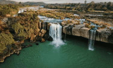
Dray Thuong Waterfall is located on the Ea Krong River, next to Kuop Buon in Ea Na commune, Krong Ana district, 18km south of Buon Ma Thuot city center. From a distance, Dray Thuong Waterfall stands out a white color on the silver water of the Ea Krong River. The two sides of the river are a vast green of the mountains. Right at the waterfall area, a very majestic image, strong impression that is the image of the Ea Krong river, with the water floating on the upstream, suddenly folded by a stone shelf across the river, about 70m wide. The rushing water in the abyss is about 08m high, echoing a corner of the forest. In the rainy season, the water is filled with the river, we only see a giant, intense waterfall. However, in the dry season, the water flow is completely, forming 09 different large and small waterfalls. Of the 09 waterfalls, there are 05 waterfalls located in the middle of the river from 05 to 10m apart, there is a rumbling water, but there is a gently murmuring water. Dray Thuong Waterfall has since become the love and attachment of the indigenous people here. Expressed through the ancient ancient story of the Ede people full of poetic, about the legend of this Thuong Sung Waterfall. The story says: In ancient times, in an Ede village, there was a very beautiful girl named H’mi, she loved a tall, healthy and gentle boy. Every day, the couple often invite each other to work. One day, after finishing the field, the two invited each other to rest on a rock under the ancient tree. When they were sweating and sweating, they saw a monster, their heads were as big as the mountain, their eyes were like a copper pot, a long beard with their arms, her hair was as sharp as the name, the whole body covered with a white scales, sparkling like silver. The monster flew up to the sky and suddenly fell to the ground like crows grabbing the bait, his legs kicked hard to make a large land sinking and there a giant water column sprayed violently, dragging H’mi was terrified, and her lover was swept away. The boy like a tiger trying to pull his lover but despair, watching his lover disappear into the fog, and sparkling white scales. Since then, the boy turned into a large tree trunk, the root was deep into the rocky rapids, the body of a suffering person who was struggling. And the huge water column turned into Dray Thuong waterfall today. And, at the other end, H’mi was still loyal to crying and crying day and night to reclaim her lover. In addition, Dray Thuong Waterfall is also associated with the following historical event: In the 1930s - 1933, the French colonialists mobilized the people and political prisoners at Buon Ma Thuot's exile house very hard and hard under their torture, torture to build an arc cross through the waterfall along with the hanging bridge across the Ea Krong River. Today, we still see the two sides have two bridges that the French colonialists have built, this is the most convincing history of the cruelty of the French colonialists at that time, there were countless people and political prisoners abandoned the bodies in the forest and abyss. And here, it is also a challenging place, practicing the gods and the will of revolutionary struggle of patriotic communists. On January 4, 1999, the Ministry of Culture and Sports issued Decision No. 01/1999/Decision -The Culture and Sports Culture recognized Dray Sap Thuong Waterfall as a national landscape monument. The management area of the waterfall is 277.5 ha. Source of electronic portal in Dak Lak province
Dak Lak
4600 view
Rating : National relics.