


The 17 Most Searched Travel Destinations in Kon Tum

The travel destinations in Kon Tum are not just impressive for their pristine natural beauty; they also deeply embody the distinct cultural essence of Tây Nguyên, Vietnam's Central Highlands. From traditional villages brimming with local charm to magnificent, awe-inspiring landscapes, each place promises an unforgettable experience for every traveler.
Thetourist attractions in Kon Tumpromise unforgettable experiences amidst the majestic mountains and forests of the Central Highlands. Beyond its pristine natural landscapes, Kon Tum is a land rich in cultural identity, featuring traditional villages, ancient wooden churches, and significant historical sites. Join63Sstravelto discover the most captivating destinations for a truly complete trip!
Related articles:
- List of 10 historical sites in Kon Tum that you must definitely "check in"
- Traveling to Kon Tum? What are the best local souvenirs and gifts to bring back home?
Top 17 Most Searched Tourist Attractions in Kon Tum
Discover the pristine beauty and unique culture of the Central Highlands through the top 17 most searched tourist attractions in Kon Tum – unmissable destinations for an experience-filled journey!
Vi Rơ Ngheo Community-Based Tourism Village
Vi Ro Ngheo community tourism villageis a captivating destination in Kon Tum, deeply imprinted with the culture of the Xơ Đăng people. Located along the Đăk Snghé River, bordering the reservoir of Thượng Kon Tum Hydropower Plant, the village not only boasts poetic natural scenery but also perfectly preserves its traditional architectural style.

Here, visitors can experience homestay tourism, immerse themselves in peaceful village life, participate in unique cultural activities, and savor local cuisine. Vi Rơ Ngheo is not just a place to explore but also contributes to improving the lives of its residents through sustainable tourism.
Măng Ri Terraced Fields
Mang Ri terraced fieldsare one of Kon Tum's most appealing tourist attractions, drawing visitors with their majestic natural beauty and the distinctive culture of the Xơ Đăng people. Nestled amidst the rolling mountains of Măng Ri commune, Tu Mơ Rông district, these terraced fields gracefully curve along the hillsides, creating a stunning natural masterpiece, especially vibrant during the ripe rice season.

In Măng Ri, visitors can not only admire the peaceful scenery but also have the opportunity to immerse themselves in the daily lives of the locals, participate in the new rice harvest festival, and discover the unique traditional cultural aspects of the ethnic community.
Our Lady of Măng Đen Pilgrimage Center
Our Lady of Mang Den pilgrimage centeris one of Kon Tum's tourist attractions that draws a large number of visitors and Catholic devotees from all over. Situated at an altitude of 1,200m amidst the Măng Đen mountains and forests, this site not only enjoys a cool climate year-round but also holds profound spiritual significance.

The statue of Our Lady of Măng Đen, with its missing hands, is considered a symbol of compassion and protection for the less fortunate. Here, visitors can not only find inner peace but also have the opportunity to discover the sacred stories associated with this unique statue.
Kon Tum Wooden Church
Kon Tum wooden churchis one of the most distinctive architectural works and historically rich sites in the Central Highlands. Built between 1913 and 1918, the church bears a strong Roman architectural influence, harmoniously blended with the stilt house style of the Ba Na people, creating a beauty that is both ancient and close to nature.
The entire structure is crafted from cà chít wood, a precious timber characteristic of the region, along with intricate carvings that showcase the artisans' skill. More than just a spiritual destination, it also serves as a space preserving the unique culture of ethnic minorities, featuring an exhibition area for handicrafts, weaving workshops, carpentry workshops, and an orphanage.
With these unique values, Kon Tum Wooden Church is not merely a religious edifice but also a cultural icon, leaving anyone who visits in awe of its beauty and profound humanistic significance.
Kon Kơ Tu Community-Based Tourism Village
Kon Ko Tu community tourism villageis an unmissable destination when exploring the Kon Tum region. Nestled peacefully beside the legendary Đắk Bla River, the village deeply embodies the traditional culture of the Ba Na people, featuring ancient stilt houses and towering communal 'rông' houses, symbols of the local community.

In Kon Kơ Tu, visitors can not only immerse themselves in the pristine, poetic natural scenery but also have the opportunity to experience fascinating local life: paddling traditional dugout canoes on the river, enjoying 'rượu cần' (tube wine) by the fire, and listening to the echoing gongs amidst the mountains and forests. This is truly one of Kon Tum's tourist attractions that fully preserves the cultural beauty of the Central Highlands, offering visitors authentic and emotional experiences.
Kon Klor Communal House (Nhà Rông)
Kon Klor Communal House (Nhà Rông) is a distinctive cultural symbol of the Ba Na people, prominently located on Trần Hưng Đạo Street, amidst Kon Tum's pristine and majestic natural landscape. Built entirely from wood, bamboo, and thatch, the 'nhà rông' boasts a sturdy appearance with a soaring roof, reflecting the resilience and strong community spirit of the Central Highlands ethnic groups.

The decorative patterns on the house's body are meticulously carved, bearing the distinct mark of Ba Na artisans, creating a structure that is both rustic and majestic. More than just a venue for community activities, festivals, or vibrant gong performances, Kon Klor Communal House is a source of pride and a symbol of the traditional beauty that the local people have preserved for generations.
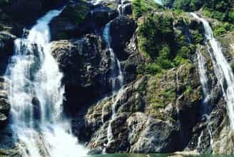
Yaly Waterfall
Yaly Waterfall is one of Kon Tum's most prominent tourist attractions, boasting a wild and majestic beauty amidst the vast Central Highlands. The powerful cascade plunges from a height of 42m, creating a magnificent spectacle of white water and frothing spray that blankets the area. At the foot of the falls lies a wide lake, dotted with small islets and naturally stacked rocks resembling steps, adding to the picturesque scenery.
On sunny days, a shimmering rainbow appears amidst the water mist, creating an enchanting natural tableau. More than just a priceless gift from nature, Yaly Waterfall is also an ideal destination for those who love to explore and enjoy the peaceful ambiance amidst the Central Highlands' mountains and forests.
Kon Bring Community-Based Tourism Village
Kon Bring community tourism villageis one of Kon Tum's tourist attractions deeply imbued with Central Highlands culture. Nestled amidst the poetic pine forests of Măng Đen, the village is home to the M'Nâm people, featuring traditional stilt houses and towering Krông communal houses.

Upon arrival, visitors can not only immerse themselves in the tranquil atmosphere but also have the opportunity to experience vibrant gong dances by flickering firelight, savor fragrant grilled chicken with bamboo-cooked rice, or listen to mysterious legends about the Măng Đen region. Kon Bring is not just a destination for those who love to explore indigenous culture but also a place that preserves the sacred spiritual values of the Central Highlands people.
Ngọc Linh Mountain
Ngoc Linh Mountain– the sky-piercing peak of the Trường Sơn mountain range, is not only a majestic symbol of Central Highlands nature but also a sacred land full of legends. Stretching across Kon Tum, Quảng Nam, Quảng Ngãi, and Gia Lai, this peak, over 2,500 meters high, appears and disappears amidst floating clouds, creating a magnificent natural tableau that captivates those who love to conquer.
The path up Ngọc Linh is a journey through dense primary forests, across babbling rocky streams, and up steep slopes that test one's perseverance. But upon reaching the summit, the reward is a vast panorama where endless mountains merge with the deep blue sky.
Amidst the windy expanse, travelers fully experience the harmony of heaven and earth, of forest birdsongs blending with the sounds of mountain rocks. The journey to explore Ngọc Linh is not just a physical challenge but also a quest to rediscover pristine values, where nature and humanity coexist in a wondrous connection.
Kon Klor Suspension Bridge
Kon Klor suspension bridgeis a proud symbol of the people of Kon Tum – gracefully spanning the legendary Đăk Bla River, connecting the poetic villages of the Central Highlands. At 292m long, this proud iron bridge boasts a rustic yet impressive beauty, making it an ideal check-in spot for nature lovers.
Standing on the bridge, you can take in the peaceful beauty of vast fields, sprawling sugarcane plantations, and Bahnar villages subtly appearing amidst the lush green expanse. More than just a transportation structure, Kon Klor is also a place for visitors to feel the rhythm of Central Highlands life, savor the rich flavor of 'rượu cần' (tube wine), listen to the echoing gongs, and immerse themselves in the distinctive culture of the indigenous people.
Kon Tum Bishop's House
Bishop's Palace of Kon Tum, built in 1935, is one of Kon Tum's tourist attractions deeply marked by history and culture. This structure stands out with its unique architecture, harmoniously blending Western styles with distinctive features of traditional Vietnamese culture.

Aside from its reinforced concrete pillars, the entire building is constructed from precious aged wood, creating an ancient and solemn beauty. Inside, visitors can admire collections of farming tools, daily household items, and artifacts reflecting the lives of the local ethnic minorities. More than just an ideal destination for history enthusiasts, the Bishop's House also offers a special experience, helping visitors gain a deeper understanding of the Central Highlands' cultural beauty.
Siu Puông Waterfall
Siu Puong Waterfall, also known as Multi-tiered Waterfall, is an ideal destination for those who love to explore and conquer pristine nature. Located about 42km from Kon Tum city, the waterfall is hidden amidst vast mountains and forests, offering a majestic yet poetic beauty.
The 240m long waterfall cascades down multiple stacked rock tiers, forming white ribbons of water like soft silk draped across the mountains and forests. Visiting during the rainy season, you'll witness the powerful torrent flowing amidst the lush green expanse of the Central Highlands.
While the journey to the waterfall can be challenging with winding roads and hilly terrain, the scenic beauty along the way, with terraced fields and gentle streams, will captivate you. If you wish to immerse yourself in pristine nature and seek a memorable experience, Siu Puông Waterfall will certainly not disappoint.
Đắk Răng Community Culture and Tourism Village
Dak Rang Community Culture - Tourism Village, located 15km from Ngọc Hồi district center, is an ideal destination for those wishing to explore the indigenous culture of the Central Highlands. It preserves almost intact the traditional architecture and customs of the Giẻ-Triêng people, creating a vibrant and culturally rich space.
Visitors to Đắk Răng can not only admire precious artifacts preserved by local artisans but also have the opportunity to experience brocade weaving, 'rượu ghè' (jar wine) making, basket weaving, and participate in lively gong cultural exchange nights. The village's cuisine is also captivating, with specialties like grilled chicken, bamboo-cooked rice, and leaf salad.
To fully enjoy life here, visitors can stay at homestays that truly embody the mountain and forest spirit. With systematic investment and poetic natural scenery, Đắk Răng is not only an ideal stopover but also a place that preserves and spreads ethnic cultural values.
Pa Sỹ Waterfall
Pa Sy Waterfallis one of Kon Tum's unmissable tourist attractions, especially for those who love wild and majestic nature. Situated at an altitude of 1,500m above sea level, the waterfall cascades down from three large streams, forming a frothy white curtain of water amidst the vast green forest. The atmosphere here is always fresh and cool, a harmonious blend of the sound of rushing water, birdsong, and stunning natural colors.

At the foot of the waterfall is a crystal-clear lake, reflecting the sky and forest trees, creating a poetic scene, like a fairyland. Standing on the wooden bridge spanning the lake, visitors can take in the entire magnificent beauty of Pa Sỹ Waterfall, often likened to a white silk ribbon amidst the vast Kon Tum wilderness.
Indochina T-junction
Indochina Junction, famously known as "where the rooster crows and three countries hear," is an unmissable destination when visiting Kon Tum. Located in Bờ Y commune, Ngọc Hồi district, this border marker sits atop a 1,086m high mountain, marking the boundary between Vietnam, Laos, and Cambodia.
Constructed from polished granite, the triangular pillar-shaped marker features the national emblem of each country carved on its sides, symbolizing the strong bond between the three Indochinese nations. Standing here, visitors can gaze upon the majestic natural scenery and simultaneously enjoy the unique sensation of being able to touch the territory of three countries at once with just one step.
Chư Mom Ray National Park
Chu Mom Ray National Parkis one of Kon Tum's appealing tourist attractions for those passionate about exploring pristine nature. Located about 30km from the city center, this national park boasts one of Vietnam's most diverse ecosystems, covering an area of up to 56,000 hectares, and is home to many rare species of flora and fauna, including 114 species listed in the Red Book.
Notably, Chư Mom Ray is also the only national park in Vietnam that shares borders with both Laos and Cambodia. Here, visitors can not only enjoy the fresh air but also have the opportunity to visit historical sites such as the Trường Sơn Trail, Phượng Hoàng Airport, or H67 – once an important military base in the Central Highlands.
Măng Đen Pine Forest
Mang Den Pine Forestis one of the most poetic destinations, offering an ethereal beauty amidst the vast Central Highlands. Located about 54km from Kon Tum city center, this forest spans an area of 140,000 hectares and sits at an altitude of 1,200m above sea level, ensuring a cool and pleasant climate year-round.

Upon arrival, visitors will immediately be captivated by the endless pine forest scenery, the lush green canopies swaying in the wind, and the fresh, pure air. Măng Đen Pine Forest is also likened to a "second Da Lat" with its wild, romantic beauty, making it an ideal stop for those who wish to immerse themselves in nature and enjoy rare tranquility.
Above are some of thetourist attractions in Kon Tumthat you shouldn't miss. We hope these suggestions will help you have an experience-filled trip and fully discover the beauty of this vast highland region.63Stravel.comwishes you memorable moments in Kon Tum!
Quang Ngai 6784 view
Update day : 11/02/2025
Monuments close by
See all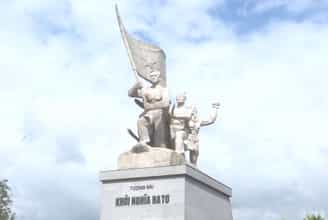
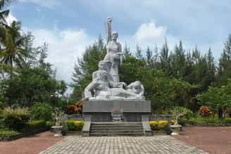
Historical relic of the Ba To uprising
The Ba To uprising broke out on March 11, 1945 with 278 guerrilla members, two days after Japan overthrew the French in Vietnam, establishing a new government in Ba To district and Quang Ngai province. The Ba To uprising was associated with the Ba To Guerrilla Team, the first armed organization of the people of Quang Ngai province directly organized, trained and led by the Communist Party of Vietnam. The Ba To guerrilla team is one of the revolutionary armed forces born in the pre-uprising period and became the core force of the revolutionary masses in Quang Ngai during the days of the general uprising in August 1945, contributing part in building revolutionary armed forces in Thua Thien - Hue and the South Central region. Many members of the Ba To Guerrilla Team later became talented officers and excellent generals of our army in the two resistance wars against the French and the Americans. In 1980, the complex of relic sites about the Ba To uprising and the Ba To guerrilla group was recognized as a national historical and cultural relic by the Ministry of Culture and Information. In 2010, the Ba To Guerrilla Team was awarded the title of Hero of the People's Armed Forces during the anti-French period by the State. Accordingly, the special national relic site of the Ba To uprising includes 11 locations:. 1. Lieng river section (Ba To town), behind Ba To station, where revolutionary soldiers pretended to have tuberculosis, demanded to live in isolation under boats, covered the enemy's eyes to print leaflets and propaganda materials Revolution. 2. Nuoc Nang brick kiln (Ba To town), where the Quang Ngai Provincial Party Committee was established at the end of December 1944. 3. Comrade Tran Quy Hai's house (Ba To town), where the Provisional Provincial Party Committee held an extraordinary meeting (March 10, 1945) to decide to rebel and seize power. 4. Suoi Loa watchtower (Ba Dong commune), where the Quang Ngai Provincial Party Committee held an emergency meeting at noon on March 11, 1945 to decide on the direction of the uprising to seize power in Ba To district capital. 5. Ba To station, the garrison of the army commanded by the French station chief, controlling Ba To district, was captured by insurgents on the night of March 11, 1945. 6. The Procuracy Department (Ba To town) is where on the night of March 11, 1945, rebel forces rounded up Procurator Bui Danh Ngu, confiscating all seals, records, documents, and weapons; take power back to the people. 7. Ba To Stadium (Ba To town), where the Ba To guerrilla team was founded and where on the morning of March 12, 1945, the Uprising's Steering Committee organized a large rally, declaring He abolished the feudal colonial government and established a revolutionary government. 8. Hang En beach (Ba Vinh commune), at the foot of Cao Muon mountain, is where on the night of March 14, 1945, the Ba To guerrilla team held the oath "Sacrifice for the Fatherland!". 9. Ben Buon (Ba Thanh commune), this is the place to receive food and weapons donated by lowland people, transported by river to supply Ba To guerrillas to build an anti-Japanese war zone in Fig Juice, Leaf Juice. 10. Nuoc La War Zone - Voot Rep Cave (Ba Vinh commune), where the Ba To guerrilla group stationed troops, built a base, and practiced military resistance against the Japanese. 11. Cao Muon Mountain War Zone (Ba Vinh commune), one of the places where the Ba To guerrilla team based itself in the early days of the uprising, building forces and cultivating Kinh-Thuong solidarity. In August 2013, the Prime Minister decided to recognize the communes: Ba Vinh, Ba Giang, Ba Dong, Ba Chua, Ba Thanh and Ba To town as belonging to the "Central Safety Zone in Quang Ngai" during the anti-French period. On December 25, 2017, the Prime Minister decided to recognize the locations of the Ba To uprising as "Special National Monuments". Source: Collection of national monuments
Quang Ngai
9468 view
Rating : Special national monument
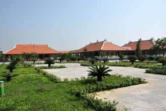
Memorial house of late Prime Minister Pham Van Dong
Memorial area of Prime Minister Pham Van Dong in Duc Tan commune, Mo Duc district, Quang Ngai. Where many high-ranking delegations from the Party and state, from Quang Ngai province and the people of the country, international friends come to commemorate and learn about Prime Minister Pham Van Dong. Prime Minister Pham Van Dong was born in Thi Pho Nhat village. Since 1925, he participated in the student movement fighting for the French to release Phan Boi Chau, and mourned Phan Chau Trinh. In 1926, he participated in a training course organized by Nguyen Ai Quoc and was admitted to the Vietnam Revolutionary Youth Association. From then on, young man Pham Van Dong embarked on the revolutionary path. The August Revolution was successful and he held the position of Minister of Finance. During the years of resistance against the French, he was a representative of the Party Central Committee and the Government in the South Central region. In 1949, he was appointed Deputy Prime Minister and from September 1954 also served as Foreign Minister and Head of the Central Foreign Affairs Commission. Then from September 1955 to December 1986, he held the position of Prime Minister. Tourists often stop for a long time at the artifacts of the late Prime Minister's daily life. A bike. One suitcase. Coffee box containing rice. Mr. Nguyen Tan Van, Former Vice Chairman of the People's Council of Mo Duc district, Quang Ngai province shared his thoughts: I visited the souvenir area many times, stopped for a long time at the bicycle and the rice cart with 4 food boxes when going. work and was touched by Uncle Ho's simplicity. Prime Minister Pham Van Dong always mingles with the people, sticks with the people, shoulders the burden, and leads the Vietnamese revolution through extremely difficult historical periods. In every position and responsibility, the Prime Minister has completed his duties excellently. During the years of resistance against the French, as a representative of the Party Central Committee and the Government, Pham Van Dong, along with martyrs Huynh Thuc Khang and Nguyen Duy Trinh, directed the fight against the French to maintain the freedom zone of Inter-Region 5. Especially , an extremely astute person in foreign affairs, was the head of the delegation of the Government of the Democratic Republic of Vietnam to the Fontainebleau Conference in France in 1946, and the head of the delegation to the Geneva conference in 1954. Although, busy Busy with national and people's affairs, Prime Minister Pham Van Dong always cares about the young generation and the country's education cause. Educate and cherish the future generations of the country and the nation. During 75 years of revolutionary activities, 41 years as a member of the Party Central Committee, 35 years as a member of the Politburo, 32 years as Prime Minister, 10 years as Advisor to the Party Central Committee, Prime Minister Pham Van Dong has made many great contributions. Prime Minister Pham Van Dong's life is a life of commitment to the revolutionary cause of the Party and the nation. The 115th birthday anniversary of Prime Minister Pham Van Dong is another time to remember and pay tribute to the contributions of the Prime Minister who always lives in the hearts of the people. Source: Quang Ngai province website
Quang Ngai
9393 view
Rating : National monument
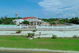
Mang Den historical relics and landscapes
Mang Den eco-tourism area is located in Mang Den town, Kon Plong district, Kon Tum province. Mang Den is a cluster of enemy strongholds, located on Road 5 from Kon Tum to Quang Ngai, now Highway 24, about 55 km northeast of Kon Tum city. This is a cluster of enemy bases deep in our liberated area. Surrounding the base is a complex system of dense obstacles with 10 layers of barbed wire and 2 layers of fence. Alternating between the layers of fence are anti-infantry mines, anti-tank mines and a trough-shaped trench 4m wide, 2.5m deep, densely planted with spikes. Inside were hundreds of blockhouses made of reinforced concrete and earthen wood, with tunnels connecting the fortifications and three corners with three mother blockhouses made of solid reinforced concrete. In mid-1974, the Kon Tum Provincial Party Committee and the B3 Command advocated attacking and destroying enemy bases to expand the liberated area and create momentum for the temporarily occupied Kon Tum area. After a period of preparation, at exactly 5:30 a.m. on October 3, 1974, the Commander of the 28th Infantry Regiment, Division 10, Army Corps 3 ordered to open fire to attack the enemy headquarters. At 7:55 a.m., our firepower simultaneously hit all targets. After a short time of developing the attack, at 10:45 a.m. we completely took control of point M12. Faced with the attack power of the H16 and H29 forces, the main force of the 28th Infantry Regiment and a number of our technical troops, on October 12, 1974, the enemy's last stronghold was located deep in the settlement area. The project in the Northeast of Kon Tum was completely wiped out. With the Mang Den victory in October 1974, our troops destroyed the enemy's last stronghold deep in our liberated area, breaking the enemy's safe corridor in the north of Kon Tum town, causing enemy troops to in the Northern Central Highlands battlefield was under strong threat. This victory liberated thousands of people and a large area of land, which was a great encouragement to promote the revolutionary actions of the people, especially ethnic minorities; At the same time, consolidate and build strong local government and armed forces. On the verge of victory, the armed forces surrounded the district capital of Mang But, liberating all the people in the area. Along with the victories at Dak Pet and Mang But bases, the Mang Den victory contributed to expanding the liberated area to Kon Tum town, creating new position and strength for the Central Highlands campaign, paving the way to liberate Saigon. , successfully ending the historic Ho Chi Minh campaign, unifying the country. Mang Den historical and scenic area was recognized as a national historical and scenic site on April 13, 2002. Source: Kon Tum Tourism
Quang Ngai
9218 view
Rating : National monument
Son My relic site
Son My relic site, located next to Highway 24B, belongs to Tu Cung village, Tinh Khe commune, Son Tinh district, Quang Ngai province. This is a place to preserve evidence of the scene, as well as a place to display images, artifacts and place a monument commemorating the 504 victims of the Son My massacre, also known as the My Lai massacre. Son My is the name the Saigon government gave to Tinh Khe commune, while My Lai is the spelling in military documents and maps, and later in the American press, to designate Tinh Khe commune. This name originates from the name of My Lai village, one of the four villages (hamlets) of Son My. Pinkville (Pink Village) is also another name for Son My used by the US military as a nickname in combat maps. The Son My massacre occurred on March 16, 1968, on February 18, Mau Than year, according to the lunar calendar. The main unit that caused the bloody event that shocked world public opinion was the 1st platoon, 11th brigade, Army division, American expeditionary force. On that "terrible morning", after heavy rounds of artillery shelling the village, American troops landed by helicopter on the fields west of Tu Cung hamlet and Go hamlet (Co Luy hamlet) in Tinh Khe commune. The insanely brutal and destructive massacre began with American soldiers hunting down and shooting civilians. Houses and shelters were destroyed, burned, and cattle were shot and killed. The climax of the brutality was the gathering of villagers, mostly old people, women and children, into groups and then shooting and killing. 102 people were killed at Watchtower, 170 others were shot in a ditch east of Thuan Yen hamlet, Tu Cung hamlet. American soldiers did not encounter any reaction from the "enemy" side, other than the screams of panic and pain from innocent victims. Their only loss in personnel was when black soldier Herbert Carter shot himself in the leg to avoid participating in the massacre of his fellow men. Horrifying truth:. In just one morning, 504 innocent civilians were killed (407 people in Tu Cung village, 97 people in My Hoi village), including 182 women, 173 children, and 60 elderly people. There were 24 families killed, 247 houses burned down. Immediately after the massacre, the National Liberation Front Committee at all levels and the Government of the Democratic Republic of Vietnam spoke out to denounce the crimes of the American expeditionary force before domestic and foreign public opinion. However, it was not until a year and a half later that this horrifying event was revealed in America by American journalists and veterans. Americans and the whole world were shocked. The movement opposing America's involvement in Vietnam spread widely. Many prestigious figures, intellectuals, and social activists in the US and many parts of the world demand that leading figures in the White House and the Pentagon be put on trial for war crimes. After the liberation of the South, the revolutionary government protected the remaining evidence after the massacre, built a memorial for the victims and a house displaying pictures and artifacts related to the Son My massacre. In Thuan Yen hamlet, Tu Cung hamlet, next to the water canal that was once red with the blood of 107 victims who were collectively murdered. After many restorations, the evidence area now has an area of 2.4 hectares, including two main areas: the field evidence area (west) that has been preserved and restored and the additional exhibition area and statues. memorial, reception house (east). In addition, there are relics related to the massacre in Tu Cung village and My Lai village. There are documentary films recording the stories and images of survivors, and many scrapbooks that visitors have written in in many languages, truly expressing the feelings and attitudes of many people. people, of many generations, many different religions, ethnicities and political trends, when learning firsthand about the Son My massacre. Source: Quang Ngai Electronic Newspaper
Quang Ngai
9174 view
Rating : National monument
Sa Huynh culture
Sa Huynh culture is an archaeological culture of the Metal Age, formed at the peak of civilization in the Iron Age dating from 500 BC, ending in the second century AD, originating from formed and developed from the previous pre-Sa Huynh cultures of the Early Bronze and Middle Bronze Ages. The distribution of Sa Huynh Culture is in Central Vietnam, the North intersects with Dong Son Culture in Quang Binh, the South intersects with Dong Nai Culture in Binh Thuan, the West is the edge of the Central Highlands, the valley area. East of Truong Son, the east reaches out to the island near the shore. The basic burial formula of the Sa Huynh Culture is tombs with jars buried in large cemeteries. At the same time, jar tombs and earthen tombs are also found at burial sites of the Sa Huynh Culture. Typical jewelry of the Sa Huynh Culture are two-headed animal earrings, three-pronged earrings, agate beads, bracelets made from gems, glass, and sea mollusk shells. Glass making and iron smithing are outstanding achievements of Sa Huynh civilization, playing an important role in promoting the development of Sa Huynh society. Sa Huynh culture has extensive exchanges with other cultures in mainland and island Southeast Asia. Sa Huynh cultural special national relic is a type of archaeological relic, with 6 relic sites including:. An Khe Lagoon, An Khe Creek - Cua Lo River, Phu Khuong, Long Thanh, Thanh Duc, Champa Relics Complex. The two locations Long Thanh and Phu Khuong have been decided by the Ministry of Culture and Information to be ranked as National Historical and Cultural Monuments. 1. Location of Long Thanh relic. Long Thanh relic site (also known as Go Ma Vuong) belongs to Long Thanh 2 residential group, Pho Thanh ward, Duc Pho town. Long Thanh is a pre-Sa Huynh relic of the early Bronze Age, the direct origin of the development of the Sa Huynh Culture of the early Iron Age. Long Thanh relic stands out with its egg-shaped and spherical jar coffins, with lids that are covered with bowls or pot tombs with two pots buried face down. The collection of artifacts features cat tongue-shaped stone picks, buffalo tooth-shaped stones, and nephrite gemstone jewelry including 4-point earrings, scarf-shaped earrings, bamboo-shaped chains, and shaped chains. The pillar is elaborately and delicately crafted. The Long Thanh artifact collection is notable for its ceramics. Long Thanh's ceramic containers are diverse in type and rich in pattern. Long Thanh relics are characterized by an early period, representing a cultural stage of the early bronze age progressing to the early iron stage of the Sa Huynh Culture. 2. Location of Phu Khuong Relics. Phu Khuong relic is a very large Sa Huynh Culture jar tomb, distributed on a large sandy plain of Sa Huynh sand dunes along An Khe lagoon, in Phu Long village, Pho Khanh commune, Duc Pho town. Relics belonging to the early Iron Sa Huynh period, jar tombs are always buried in clusters on sand dunes along the coast, next to freshwater lagoons and therefore somewhere nearby are the residential relics of the owners of the jar tombs. Phu Khuong. Inside the jars are many burial items, some jars contain human remains, burial relics in the jars include pots, bowls, ceramic vases, iron objects, jewelry including earrings, glass bracelets and semi-stones. precious. Phu Khuong relics are characterized by precious stone jewelry, which are dark red beads made of agate stone with many shapes such as flat squares, diamonds, diamonds, hexagonal polyhedrons, and bowls. sense. 3. Location of Thanh Duc Relics. Thanh Duc relic is the tomb site of Sa Huynh Culture jars distributed on the Sa Huynh sand dunes, between one side is the sea and the other side is the salt water lagoon of Tan Diem salt flat area, belonging to Thanh Duc residential group, Pho Thanh ward. , Duc Pho town. Thanh Duc jar tomb area has a very large number of burial jars, if we count the total number of jar tombs excavated, it reaches 175 jars. The jar contains burial relics such as bronze objects, iron tools, nephrite stone jewelry and earrings, and many ceramic containers. Thanh Duc bronzes have bronze rattles, this is evidence of exchange between Sa Huynh Culture and Dong Son Culture. Especially in Thanh Duc, there are bracelets made of copper and iron combined. This is a unique relic found for the first time in the Sa Huynh Cultural relic. 4. Champa relic complex in Sa Huynh space. The Champa relic complex in Sa Huynh space includes: Mot Mountain Tower, Go Da Tower, Stone Bridge, Champa Temple (Temple of Tho Chu), Champa inscriptions, Champa well system, ancient stone folding road (Sa Huynh - Champa - Vietnamese), Champa ancient irrigation ditch system. Regarding the current status: Champa towers such as Mount Mot tower only have ruins of the base of the tower left. Go Da Tower has traces of its base located next to Thien Ly route. Ancient stone roads, ancient irrigation ditches, and ancient stone bridges are still intact. 5. An Khe Lagoon. An Khe Lagoon is located next to National Highway 1A, in Pho Khanh commune, Duc Pho town, Quang Ngai province. An Khe Lagoon has outstanding value as the largest freshwater lake next to the sea in Vietnam, a transition place for terrestrial and marine ecosystems, coexisting in an overall ecosystem of freshwater, brackish water, and freshwater. salinity and agricultural production, playing an important role in the environment and socio-economic development of the region. 6. An Khe creek, Cua Lo river. To the east of An Khe lagoon, there is a small narrow creek draining into the sea with an area of 58.5 hectares. At the end of the creek is the lagoon mouth - local people often call it Cua Lo, this mouth is almost closed all year round. An Khe lagoon, creek and Cua Lo river are associated with the formation of Sa Huynh Culture, and are the basic natural conditions for the formation of Sa Huynh Culture, Champa Culture and Vietnamese Culture relics in the surrounding area. dress. Source: Duc Pho town cultural and sports information center
Quang Ngai
9026 view
Rating : Special national monument
Nearby tourist attractions
See all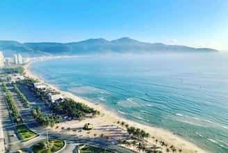
My Khe Beach
More than 10km east of Quang Ngai city center, there is a beautiful, vast stretch of beach called My Khe. Located in Co Luy village, Tinh Khe commune, Quang Ngai city, My Khe beach is located next to the banks of Kinh river, not far from Sa Ky port and only 3km from Son My relic site. With whispering waves from the clear blue water hitting the smooth white sand beach in a romantic, cloud-filled space, My Khe beach will definitely attract you from the first time you set foot there. Not only does it have blue sea, white sand, golden sunshine, My Khe beach also possesses the pristine nature of immense green poplar forests occupying a part of the sandy shore of the poetic crescent sea. Near the coast are simple, peaceful fishing villages with gentle and rustic Quang fishermen. On the sea surface, basket boats and fishing boats float lazily on the calm sea surface, adding to the simple features of human life here in the already extremely romantic and poetic sea landscape. . Coming to My Khe beach - Quang Ngai, not only can you admire the natural scenery of the picturesque sea, enjoy the peaceful space, immerse yourself in the cool water to dispel the fatigue of life, but You can also organize camping on the shore, organize games on the beach and have fun with relatives and friends. Once you come here, don't forget to enjoy delicious dishes made from the rich variety of seafood from the freshwater upstream of the Kinh River mixed with the salty taste of My Khe sea. In addition to activities at sea, combine your trip with a visit to the Son My war relic site, only 3km away, for a more complete Quang Ngai travel experience.
Quang Ngai
7331 view
March to October
Ly Son Island
With two distinct rainy and sunny seasons, the best time to travel to Ly Son is from April to August. During this time the weather is stable, it rains little and is sunny. But you should avoid going during the peak season from April to June, so you don't have to endure crowds. September to December is the season of rain, storms and rough seas. From late December to April is the season of green moss covering the rocky beaches along Ly Son coast. Note, you need to monitor the weather before departing to avoid being stuck on the island for several days due to rough seas, monsoons... The main means of transportation is by boat from Sa Ky port. There are many high-speed boat companies here that take tourists to Ly Son island with ticket prices around 300,000 - 340,000 VND (round trip). Remember to bring your ID card or driver's license to buy tickets. Travel time from port to island is about 35 minutes. From Hanoi and Ho Chi Minh City, tourists book flights to Chu Lai airport with a one-way ticket price of about 1,200,000 VND, flight time 1 hour 30 minutes. The airport is about 42 km from Sa Ky port, you can travel by taxi, one-way price is about 350,000 VND or take a bus that stops in Quang Ngai City to save costs. In addition, visitors have the option to fly to Da Nang, from here take a taxi or train to Quang Ngai City, the train ticket price is 180,000 round-trip. The port is 20 km from the city center. Ly Son has many motels, hotels, and homestays, averaging from 200,000 - 400,000 VND per night. For travelers who prefer a place with a youthful style, they should choose homestay Bep's House, Bé Ecolodge or DHT Hang Cau motel. In addition, visitors can refer to Ly Son Pearl Hotel & Resort with sea view. Visitors can experience staying one night at Be island. Suggested homestays are Ly Son Bungalow with colorful wooden houses, XaLaBin with high rooms with sea view or Sea Breeze. Coming to Ly Son, visitors can rent an electric car for 300,000 VND per trip to explore around the island. In addition, you can rent a motorbike, priced at 150,000 VND per day, to visit places such as: Thoi Loi Peak, Garlic Fields, Cau Cave, To Vo Gate, Hang Pagoda, Duc Pagoda,... and many famous places. another language. Regarding cuisine in Ly Son, restaurants are concentrated along the port, some suggested restaurants are Phat Hai restaurant, Khoi Chieu restaurant... There are also Dai Hang seafood rice restaurant, Ut Ngoc restaurant. Ly Son's specialties are mainly seafood, especially king crab, lobster, conch, ta ma fish, fish cakes... Some other specialties are garlic salad, seaweed salad, crab vermicelli, and melons. black watermelon, giant snail, banh it gai leaf... Visit the dry food stalls on the island to buy garlic and dried seafood as gifts.
Quang Ngai
7877 view
From December to April
Minh Long white waterfall
White Waterfall is located in Thach An commune, Minh Long district and about 23 km southwest of Quang Ngai City center. The waterfall is hidden in the historic Truong Son mountain range and has recently been discovered by people. This is an ideal destination for those who want to rest and relax on the weekend and is a favorite place for backpackers today. To go to White Waterfall, from the center of Quang Ngai city, go southwest to Chua market town, Nghia Hanh district. After that, there will be a small pass. If you follow that road, you will reach Minh Long district and continue about 5 km to reach the White Waterfall. The road to the waterfall is now being rebuilt very beautifully, the road is also quite steep so it brings an interesting feeling to backpackers. To get here, an advice for you is to ask local people for directions as you go because following google map will not be accurate. If you don't want to ride a motorbike, you can go by car or catch the bus from Quang Ngai - Minh Long for only 16,000 VND/trip. To Minh Long district, you can catch a motorbike taxi to the waterfall, or rent a motorbike. Motorbikes for only 80,000 VND-120,000 VND/day. White Waterfall is about 40 m high, the water flows day and night into the two lakes below. The waterfall is surrounded by the green of rolling hills and mountains, creating a very poetic and lyrical scene. The waterfall is divided into 3 branches, of which the leftmost branch is the main branch (this is where the water flows the most and most intensely), the remaining 2 sub branches on the right flow less water. At the foot of the waterfall there are 2 large lakes, the water here is very clear and blue, the cool water is very suitable for people to immerse themselves in the refreshing water to dispel the heat of the city. Not only that, this lake is also home to juvenile fish, so you can bring fishing rods and enjoy this delicious, unique dish right on the shore. The water flow is strong and light depending on the season. To admire the strongest water flow, you should come here during the rainy season, when there is a lot of water flowing from above, causing the water flow to be very strong, creating a wonderful scene. Pretty. If you like the peace and simplicity of White Waterfall, you should go in the dry season, when the water flows very gently and smoothly. Coming to White Waterfall, not only can you bathe freely in the cool water and take wonderful photos, but you can also camp, picnic, organize group games, light campfires and lots of other interesting things. The waterfall has been turned into a tourist area so you can have peace of mind about eating, resting, and entertainment. Next to the waterfall there is an empty lot, which is a very suitable place for camping overnight, singing and dancing, and enjoying outdoor BBQ dishes. Around the waterfall, there is also a place suitable for young people who love nature and want to explore: the primeval forest and the villages of the Hre people. If possible, you can also ask permission from the forest management board to camp and play here. Leaving behind the stuffy air of the city and the hot summer afternoons, try coming here once, enjoy the cool air here and you will feel really comfortable and not want to leave. get out of here for a bit.
Quang Ngai
7823 view
From January to December
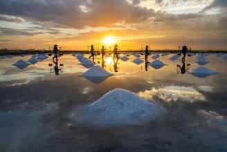
Sa Huynh salt field
Wearing endless beauty over time, Sa Huynh salt fields are a place for visitors to see the stretching salt fields, the beautiful white colors and feel the essence of the folk craft villages here. Located in Pho Thach commune, Duc Pho district, Quang Ngai, this is not only a salt field with more than 100 years of history, but also symbolizes the connection with the heritage and culture of this land. With more than 600 households and an annual salt output of 8,000 to 9,000 tons, Sa Huynh salt field is not only an important source of salt but also represents the spirit of traditional craft villages, blending with famous craft villages. Others like Hon Khoi and Ca Na are located along the Central region. Since the 19th century, Sa Huynh salt fields have witnessed more than 100 years of preserving tradition. However, salt making in Sa Huynh was not always known as a beautiful landscape. In the past, this place has gone through many ups and downs, from the "bitter salt village" when the effort put in did not achieve results, to the value of salt not being expected and the lack of local brands. But since the day the Intellectual Property Department issued the certificate of "Sa Huynh Salt" in 2011, everything has changed. Salt makers do not hesitate to invest and apply new production models, with Sa Huynh salt making on tarpaulin or cement floors. The results have shown an improvement in quality, with sand impurities reduced by up to 95%, output significantly increased and salt value increased by 20 - 30%. In particular, this new method helps shorten production time and change the landscape of the salt fields. To do this, 6 dikes with a total length of more than 5km were built, paving the way for the development and improvement of the salt fields. This proves the enthusiasm and will for progress of Sa Huynh salt makers, as they constantly learn and share knowledge, building a bright future for Sa Huynh salt grains. With more than 120 hectares of area, Sa Huynh salt fields are like a brilliant carpet, each small field interwoven with each other, understanding the delicate interaction between sunlight and sea water. The concrete and silver foil create a unique reflection of color, turning this beautiful scene into a field that sparkles like diamonds and attracts all eyes. White salt dunes spread evenly across the fields, like embodiments of mountain and forest nature. When the sparkling golden sunlight combines with the farmer's bamboo burden, the painting blends yellow and white to create a captivatingly beautiful scene, blending simplicity and charm, like a mysterious portrait. . When you enter the salt field, this is not only a famous Quang Ngai tourist destination, but also an interesting work of natural art from the hands of farmers. Right from 5 a.m., local farmers gathered to start an enthusiastic working day. They arranged seawater from canals and ditches into the bladder, then sprinkled bait salt and waited for the sunlight to crystallize the salt. Salt making in Sa Huynh requires 3 sun exposure to achieve white and large salt grains. This is an elaborate process, performed under intense sunlight, to create unique and delicious quality salt. In addition to the salt making experience, you also have the opportunity to see unique homemade motorbikes here. These carts, although old, have been converted to carry salt instead of being used for carrying loads. This has improved people's lives and created a sense of fun. If you have the opportunity, please shop and support these pure grains of salt, to see the care and love that people put into each grain of salt.
Quang Ngai
7701 view
March to August
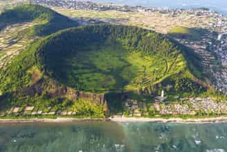
Cape Ba, An village
When mentioning Quang Ngai, surely those who love to travel will immediately think of Ly Son island district. However, in Quang Nam, there is another pristine land like "Ly Son Island in the mainland" waiting for tourists to explore. Mui Ba Lang An is located in Binh Chau commune, Binh Son district. The reason for this name is because this is a way to combine the names of three adjacent auspicious places including Van An, An Chuan and An Hai. Here, visitors will enjoy the extremely peaceful life of the Central region's sea and islands. The people of Mui Ba Lang An are also the people who reclaimed Ly Son island, and directly participated in the fight to protect the sovereignty of Hoang Sa island and sea. During the French colonial period, this place was also called Ba Tang tend. This is not only a resort destination but also famous for its rich history, always the pride of Quang Ngai people. Currently, Mui Ba Lang An has been expanded in area and is only about 22km southwest of Cu Lao Re island. This is a cape that helps create the shape of the coastline in our country, and will definitely be an attractive destination for tourists. This cape is made up of volcanic sedimentary cliffs and clear jade blue sea. Looking from above, one can see the extremely magical and seductive beauty. Near Ba Lang An Cape, there is also an inactive volcano crater about 30 square meters wide. Inside the crater, there is a lot of seaweed growing, and the outside is covered with a dense layer of coral with many bright colors. All of these points are blended together, creating a unique wild beauty that can rarely be found anywhere in Quang Ngai. Visiting Ba Lang An cape, visitors will have the opportunity to experience many interesting things such as walking along the beach to admire the scenery and take photos. In addition, you must definitely visit Ba Lang An lighthouse. Just spending about 30 minutes up the lighthouse, visitors will have the opportunity to see the majestic panorama of the cape. After posing and taking many beautiful photos, visitors can continue to admire the beautiful natural landscape. If you are a lover of the sea and enjoy experiences, want to touch your feet and feel the cool ocean water or try touching the undulating rocks below the beach, you can move down to Ba Lang An cape. Surely this will be an impressive experience during your trip to explore Quang Ngai. In particular, when visiting Ba Lang An cape, visitors will have the opportunity to enjoy and breathe the simple life of fishermen on boats and baskets going out to sea. Boats moored on the shore will be an indescribably simple moment that you will not see in the city. However, this place has not really received much investment in tourism development. Therefore, visitors may have to travel further to find the ideal hotel or homestay to stay. Coming here, visitors can go back and forth in the same day because the road is quite convenient and not too far from the center. If you want to stay overnight at the beach, you can ask to sleep at a local family's house. Besides, visitors should prepare comfortable clothes when traveling to Quang Ngai to be able to operate easily. At the same time, sunscreen is indispensable, as well as a jacket, and sunglasses, etc. These are all important accessories because the weather here is quite hot. The most beautiful time that tourists should not miss to come to Ba Lang An cape is from May to August. This is the time when the weather is beautiful and the waves are calm. Because it is not the rainy season, it is very suitable for swimming and admiring the beautiful mountain scenery. However, this is also the peak season for beach tourism in Quang Ngai. Therefore, service prices may increase higher than at other times of the year. You should avoid traveling to Cape Ba from September to February of the following year. This is the rainy season in Quang Ngai, in addition to long rainy days, there are big storms that make strong ocean waves, which will be a factor affecting the quality of your trip.
Quang Ngai
7714 view
From May to August