Relic point Vietnam
Việt Nam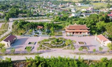
Hero Ly Tu Trong memorial area
Heroic Martyr Ly Tu Trong Memorial Area is located in Tan Long village, Viet Xuyen commune, Thach Ha, Ha Tinh. This is a project of the youth of the country and the people of the province to pay tribute to the heroic sacrifice of heroic martyr Ly Tu Trong - the first member of the Communist Youth Union. Heroic martyr Ly Tu Trong's real name is Le Huu Trong, born in 1914 in Ban May, Nakhon Phanom province - Thailand, originally from Thach Ha district, Ha Tinh province. He was born into a family whose parents were both patriotic overseas Vietnamese. Born in a situation of "losing his country and home", his family had to travel to Thailand to live, always carrying in his heart the longing for his homeland, which was being invaded by enemies. Since he was young, Le Huu Trong was hardworking, eager to learn and soon became enlightened about the revolution. He was one of eight children selected by Ho Tung Mau to take him to Guangzhou - China to study and work in the association. patriotic youth, here Le Huu Trong was renamed Ly Tu Trong by comrade Nguyen Ai Quoc. After returning home, work. In 1931, during a rally commemorating the first anniversary of the Yen Bai uprising held in Saigon, Ly Tu Trong shot and killed secret agent Le Grand to protect speaker Phan Boi who was giving a speech at Lareni Square. He was later captured by the enemy and sentenced to death when he was only 17 years old. Although he fell at a very young age, hero Ly Tu Trong left behind generations of Vietnamese youth a valuable legacy, which is patriotism, courage and youthful enthusiasm. Ly Tu Trong went down in history with his famous statement before the enemy's court, "The path of youth is only the revolutionary path, there can be no other path", which has become a guideline and a model. A shining example for Vietnamese youth to study and follow. On April 30, 2011, 80 years after his death, Anh's remains were found and brought back to be buried in his hometown. According to the earnest wishes of officers, soldiers, people of Ha Tinh and youth union members nationwide, the Secretariat of the Central Committee of the Ho Chi Minh Communist Youth Union has approved the investment project to build a memorial area. Ly Tu Trong in Viet Xuyen commune, Thach Ha district, Ha Tinh province. This is a tribute to the young communist man; has historical, cultural and spiritual significance; Traditional education for children nationwide. On October 20, 2011, on the occasion of the 97th birth anniversary of hero Ly Tu Trong, the Standing Committee of Ha Tinh Provincial Youth Union held a groundbreaking ceremony to build the Memorial Area. On October 20, 2014, the project was completed on the occasion of the 100th anniversary of Britain's birth. Source: Ha Tinh Province Historical Archives Center
Ha Tinh
6430 view
Rating : National monument
Phai Khat Fort
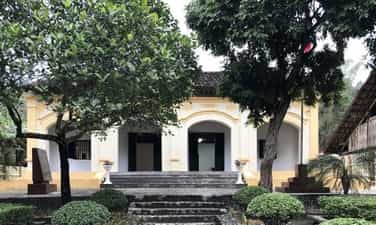
Phai Khat Fort is located in Tam Kim commune, Nguyen Binh district, 7km from Tran Hung Dao forest. Here, on December 22, 1944, the Vietnam Liberation Army Propaganda Team was established. President Ho Chi Minh instructed the Team to develop a plan to organize a battle to "encourage the revolutionary fighting spirit of an enslaved nation, seething with the will to rise up", at the same time " overcome the situation of lack of weapons and equipment". Under the command of comrade Vo Nguyen Giap, the Team discussed carefully to clarify the issue: "Where to attack and how to attack, so that with only a small force we can win a great political victory." political and military, while limiting the loss of our people and weapons. After discussing options, the Team Command decided "to raid the enemy's camp to capture ammunition", the goal. Targets are Phai Khat and Na Ngan stations. The garrison force consisted of two squads, under the direct command of comrade Van (Vo Nguyen Giap). In addition, there was also the participation of guerrillas and local Viet Minh officers on duty to guard the roads leading to the village. In order to break in smoothly, comrade Vo Nguyen Giap prepared a fake patrol permit with a red stamp to serve in the battle. On the afternoon of February 24, the forces participating in the battle disguised themselves as soldiers and marched to Phai Khat. After receiving news that Station Chief Simono was going to the capital of Nguyen Binh, at 5:00 p.m. on February 25, "Squad" Thu Son led his troops into the station easily. The team quickly divided into two prongs: Platoon 1 captured the gun storage area, Platoon 2 surrounded the station. While the enemy had not yet reacted, comrade Thu Son shouted: "Rat-sam-mang" (gather), 17 soldiers and the commander gathered in the middle of the yard. The enemy was surprised and could not react in time and quickly surrendered. The battle took place quickly, and Simono returning from Nguyen Binh was also destroyed. As a result, we destroyed 1 enemy and captured 17 enemies, capturing 17 guns, some ammunition and military equipment. After defeating Phai Khat post, on the night of December 25, the Team urgently marched to Cam Ly commune (15km from Phai Khat), where Na Ngan post was located. The team learned from experience and praised the comrades for completing the task well, and at the same time disseminated the attack plan the next day. Due to the dangerous terrain of Na Ngan station, the Team decided to disguise themselves as a group of soldiers and red loincloth soldiers to escort three Man Communists to hand over to the station. The force attacking Na Ngan garrison was all members who participated in attacking Phai Khat garrison. At around 7:00 a.m. on December 26, comrade Thu Son and the volunteer team led three tied communists into the station along with the tricolor flag (the team got it at Phai Khat station). The soldiers thought they were in a hurry to arrange 6 soldiers and the commander to line up to welcome them according to military protocol. After the whole team entered the station, according to the assigned plan, four soldiers approached the middle of the gun rack. Comrades Thu Son and Be Van Sat talked to Duong to create a distraction. Platoon 2 blocked the station gates, then divided into groups to capture prisoners. Platoon 3 fired into the air while calling for the enemy to surrender. At the end of the battle, we destroyed 5 people, captured 17 people, and collected 27 guns and many bullets. In this battle, comrade Nong Van Be was slightly injured. After taking down the station, the Team quickly collected guns, ammunition, documents and distributed leaflets and banners to the people. The group of prisoners of war was gathered in the middle of the yard. Two female comrades Cam and Thanh explained in Tay language to them to understand the Viet Minh's policy of fighting the French and Japanese to save the country, calling on them to turn their guns on France and Japan to win independence for the nation. After hearing the policies of the Viet Minh, some prisoners of war asked to join the revolution and most asked to return home. In the first two battles, the Team used the tactic of "attacking with a disguised raid (raid), which excellently opened the tactical history of the Vietnam People's Army". Training disguise is a way of fighting that uses few guns and bullets, has low casualties but is highly effective in combat. In the first two battles, in addition to destroying and capturing all enemy soldiers in the station, the Team also captured many weapons and military equipment. Most importantly, the team won in accordance with leader Ho Chi Minh's directive "The first match must be successful". Source: Cao Bang electronic information portal
Cao Bang
6279 view
Rating : National monument

Tan So Citadel Ruins
Tan So Thanh Base Relic is located in Mai Dan village, Cam Chinh commune, Cam Lo district. Tan So Citadel Base Relic was ranked National by the Ministry of Culture and Information on January 16, 1995. This is a relic of the last military citadel of the feudal dynasty of the Nguyen Dynasty marking historical events. Important history of the Can Vuong movement against the French in the early 20th century. Tan So is a land isolated from the plain and far away from the center of the provincial capitals. Surrounded on all four sides are mountain peaks and natural hills created like a closed citadel. The east side faces the Trieu - Hai plain, which is very convenient for communication with the lowlands. On the other sides, there are roads leading through Laos and to the North in case of retreat, so this place has been chosen by the feudal monarchy through the ages as a border guard post and mountain guard station. In 1883, it changed to Quang Tri Son Phong, also known as Tan So citadel. The resistance base in Tan So began construction in 1883 and was completed in 1885. Under the direction of mandarins: Nguyen Van Tuong, Ton That Le, Dang Duy Cat, thousands of soldiers and villagers worked diligently day and night. It was from the work of digging soil and planting bamboo to build the Tan So base that took a lot of effort, but our people did not think about their own benefits and had a song: "Eat home and carry bamboo and ivory for the mandarins." . Tan So citadel has a rectangular structure: length 548m, width 418m, total area is 22.9 hectares. The outer citadel has 4 gates: Front, Back, Left, Right covered with soil, outside there is a fence with sharp stakes and a surrounding moat system (2m deep, 10m wide), 4 sides of the wall are densely planted with ivory bamboo in four layers. Dozens of meters apart, between layers of bamboo is a wall made of soil. The 4 corners of the citadel have 4 wells 20m deep. Inside the outer citadel there are houses, barracks, warehouses, and training grounds for elephants and horses; At the gates and corners of the citadel, there are military posts and gun emplacements to guard and protect the inner citadel. The inner citadel was built of solid bricks, length is 165 m, width 100m, total area is 1.65 hectares. The inner city has 5 gates: Tien, Hau, Left, Right and Ngo Mon for the king and mandarins to enter and exit the palace. Inside the citadel, there are buildings where officials live and work. The French colonialists, after being attacked by the Nguyen Dynasty's imperial army, took brutal revenge. They caused a brutal massacre of the people of Hue capital, then immediately invaded Tan So, capturing King Ham Nghi and the leaders of the militant faction. In the end, the French captured Tan So, they burned it down and completely destroyed it. Tan So was engulfed in flames, signaling the end of a capital city - a nerve center leading the Can Vuong movement, recording an extremely heroic historical milestone against foreign invaders of our nation, becoming the place where witnessed and recorded the national spirit of a patriotic king - King Ham Nghi. After peace, Tan So was littered with piles of war scrap and filled with hundreds of bomb craters. The Tan So Citadel Base relic is in dire need of preservation and restoration. Source: Quang Tri Newspaper
Quang Tri
5199 view
Rating : National monument
Quang Binh Quan
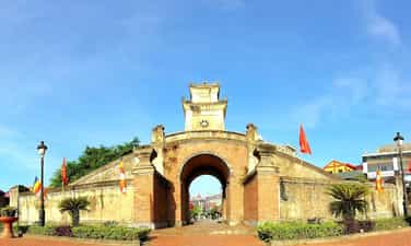
Quang Binh Quan (newly restored), right in the center of Dong Hai ward between four roads: the west is the road to Duc Ninh, the east is Me Suot road down to Nhat Le river wharf, the north is the road to Hanoi Noi, the south is the road to Hue. Quang Binh Quan also has many names. Some people say it is the entrance to Quang Binh palace, others say Binh Quan Gate. The book Dai Nam Nhat Thong Chi records: ''The mandarin gate is two truong 1 meter long, two truong 5 meters wide; The outer citadel protecting the mandarin gate is 14 meters long, 6 meters high, 3 meters high, built in the year of Minh Menh (1826) with brick and stone...'' Quang Binh Quan under the Nguyen Dynasty, covered with soil in 1631, is an ancient rampart system built to protect the Nguyen citadel. Quang Binh Quan is located in the Luy Thay system, including Luy Truong Duc, Luy Tran Ninh, Luy Nhat Le, Luy Truong Sa, stretching more than 30 km. The Luy Thay system was designed and directly directed by Lord Nguyen's military advisor Dao Duy Tu (1572-1634) and directly directed its construction from 1631-1634, to help Lord Nguyen in Dang Trong fight against attacks by Lord Trinh in Dang Ngoai during the Trinh - Nguyen period was divided. This place has a mountain-like terrain near a very solid ravine, separated from the North, extremely dangerous, like going into Thuc land. During the reign of Lord Nguyen, if people from Southern Bo Chinh or from the North had any business, if they wanted to go to Quang Binh palace, if they went by road, they had to first go to Quang Binh Quan to present their documents and then go back to the north and enter Nam Mon gate to leave. castle. Those traveling by water must stop by the boat at Nhat Le gate, present documents at Thu Ngu mandarin gate, then take the boat to the east gate to enter the citadel. Quang Binh Quan is located guarding the North-South vital road and waterway from Nhat Le seaport. Therefore, more than 7 times Lord Trinh's army crossed the Gianh River to the South and were stopped here. As painful evidence of a time of national conflict, Quang Binh Quan as well as the Luy Thay system have shown the high development of the architectural art of Vietnamese military fortifications. This place is the center of the Luy Thay rampart system, Quang Binh Quan was built according to a unique architectural model, harmoniously combining two elements, both a solid and solid defensive battle rampart, and a a unique architectural work of art. Quang Binh Quan is a reliable address for future architectural and military researchers. In 1825, King Minh Mang restored Quang Binh Quan and raised the watchtower with solid baked bricks. After inauguration, the king classified Quang Binh Quan as one of the special historical and cultural works. of the country, having the image of Quang Binh Quan embossed in Nghi Dinh placed in front of The Mieu Temple in the Forbidden City. Before the August Revolution of 1945, Quang Binh Quan (on Duc Ninh Street) also had a moat outside the citadel, a brick bridge around the moat and at the intersection between Duc Ninh and Cau Rao streets (in the past, during the Nguyen Lord's time, it was the There is also a ghost in a large cemetery. Quang Binh Quan was destroyed by the French army when they withdrew from Dong Hoi in 1954, then rebuilt almost identically. In 1965, the war broke out and was destroyed by American aircraft. Currently, Quang Binh Quan has been restored to its original appearance more than three centuries ago. Quang Binh Quan, an architectural relic with historical and artistic value, is a typical cultural symbol of the land of outstanding people. Source: QUANG BINH GENERAL MUSEUM
Quang Tri
4704 view
Rating : National monument
Memorial area for cultural celebrity Le Quy Don
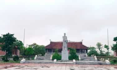
The memorial area of scientist Le Quy Don in Dong Phu village, Doc Lap commune, Hung Ha district is a place to store and preserve artifacts and traces that were closely associated with the scientist - an outstanding Vietnamese cultural celebrity. Male. Le Quy Don's real name is Le Danh Phuong, full name is Doan Hau, nickname is Que Duong, born on the 5th day of the 7th month, year of Binh Ngo, that is, June 2nd, 1726 in Dien Ha village, Son Nam Ha town, now is Dong Phu village, Doc Lap commune, Hung Ha district, Thai Binh province. His father, Le Trong Thu, passed his PhD as an official at the Ministry of Justice and Marquis. Her mother is Truong Thi Ich, daughter of Dr. Truong Minh Luong, who is a Hoang sect official. When he was young, Le Quy Don was famous as a child prodigy. In 1739, he followed his father to the capital to study with Dr. Le Huu Kieu. At the age of 18, Huong passed the exam and won the first prize, then stayed home to teach and write books. At the age of 27, he passed the Hoi exam and passed the Dinh exam. Le Quy Don successively worked at the Academy, the Toan Committee to study national history, went to Liem Phong to participate in military affairs, went to China as an ambassador, worked at Lord Trinh's palace... and was gradually promoted to the positions of Academy Officer and Private Career. Quoc Tu Giam, Litigation, National History General, Hiep Town... In 1784, he was promoted to Minister of Public Affairs, titled Nghia Phai Marquis. That same year, he fell ill and returned home to recuperate in his maternal hometown, Nguyen Xa village, Duy Tien district. (now in Ha Nam province) he died here on the 14th day of the 4th lunar month at the age of 58. His wife is Mrs. Le Thi Trang, daughter of school teacher Le Huu Kieu. He has four sons, Quy Kiet, Quy Ta, Quy Chau, Quy Nghi. Le Quy Don's creative career is very voluminous, he has written about 40 books of all kinds including most contemporary knowledge such as history, poetry, philosophy, classic commentaries, general categories... which is a treasure trove. precious treasure of the country's academic system. The memorial area for cultural celebrity Le Quy Don includes three works: From the street of cultural celebrity Le Quy Don, the mausoleum of Le Trong Thu (Le Quy Don's father), and Le Quy lake. 1. From the street of cultural celebrity Le Quy Don Tu Duong includes the five-room Bai Duong court, the Middle Palace and the Hau Palace, each with three compartments. Tu Duong's predecessor was the home of Le Quy Don. When his father passed away, Le Quy Don converted it into Tu Duong, until his lifetime. Le Quy Kiet also brought Le Quy Don's tablet back with his grandfather. Local people often call this place from Le Quy Don street. 2. Le Trong Thu Tomb. Le Trong Thu (1693 - 1783), was a mandarin during the Le Trung Hung period in Vietnamese history. He was the father of a great Vietnamese scientist during the feudal period, Le Quy Don. Le Trong Thu, Mr. Truc Am, studied very brightly as a child, was famous as a prodigy, and grew up studying with the Vu family's Tham Hoa in Ha Nam. At the age of 27, Le Trong passed Huong Tien, at the age of 31, he passed the 3rd rank of Doctorate. Origin, Giap Thin department, Bao Thai year 5 (1724), reign of King Le Du Tong and Lord Trinh Cuong, served as an honest mandarin Famous inside and out, at the age of 65, he retired to the position of Household Minister Huu Thi Lang. Not long after, he was invited to become a mandarin for the second time, promoted to the position of Minister of Justice, then retired at the age of 80. 3. Ho Le Quy. In the 26th year of Canh Hung (1765), he asked the court to return to his hometown to "close the door and write books". To relax and have conditions to read and write books, Le Quy Don dug a large lake. In the middle of the lake, build a small island, plant ornamental plants, and build a Thu Lan. During this time, he wrote many books "specially focusing on geography" such as: Geography of Essence, Compendium of Geography... Perhaps the chapter on images and products in the Van Dai language series was also prepared with documents from this period. The Memorial Area of cultural celebrity Le Quy Don was ranked a National Monument by the Ministry of Culture, Sports and Tourism on December 12, 1986. Source: Department of Culture, Sports and Tourism of Thai Binh province
Hung Yen
5390 view
Rating : National monument
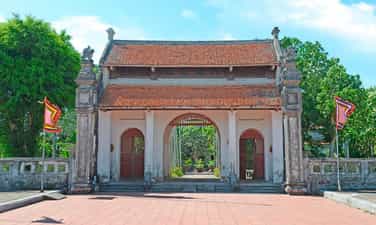
Pho Minh Tower Pagoda
Pho Minh Pagoda, whose name is Pho Minh Tu, is a pagoda located in Tuc Mac village, Loc Vuong ward, Nam Dinh city. Based on the ordination stele as well as ancient bibliographies, the pagoda was built during the Ly dynasty, and in 1262 the Tran dynasty expanded to a more grand scale. In 2012, Pho Minh Pagoda was ranked by the Prime Minister as a special National Monument. Because in front of Pho Minh Pagoda there is a tower, the pagoda is also known as Chua Thap, the Tower is also known as Pho Minh Tower. Pho Minh Tower is a unique architectural work. This is the largest, oldest and most intact tower in Vietnam. The book Nam Dinh Province Geography by author Khieu Nang Tinh records about the pagoda as follows: "During the Tran Dynasty, King Nhan Tong restored his residence as a monk. When the king died, Anh Tong built a 14-storey tower, 53 meters high, with 10 meters on each side to house the relics. During the Tay Son period, the governor of this region broke the top of the bronze gourd tower. When we reached the 13th floor where the stone was, we saw an object shaped like a red ribbon flying into the sky, so we stopped destroying it..." In addition, among the people, there is also a saying of Buddha Emperor Tran Nhan Tong: “No matter who competes for the throne I would like to send back this handful of temple bones." Therefore, researchers believe that this is a tomb tower. Currently in the country there are only three towers built during the Tran Dynasty: Pho Minh tower (Nam Dinh), Hue Quang tower (Yen Tu, Quang Ninh) and Binh Son tower (Lap Thach, Vinh Phuc), but Pho Tower Minh is still the more majestic tower, with the most elaborate, artistic, and technical construction. The tower was built right in front of the worshiping house on the North - South axis. The tower has a total height of 19.51m including 1 palanquin and 13 floors. The tower is built on a small square yard, each side is 8.6m and located 0.45m lower than the ground. The palanquin is the base of the tower designed entirely of green stone, each side is 5.20m long. At the foot of the tower there is a lotus flower with large petals and small petals, gradually tilting towards the corner of the tower from the middle, symbolizing a lotus platform holding a palanquin. The lower part of the stone pedestal is shaped to curve up on both sides, making people mistakenly think it is due to the rock sinking, but in fact, the construction was intended to create momentum for the more than a dozen floors above to have the same curvature. Looking at the entire tower, people will think of a Lotus flower rising and blooming in the middle of a lake. From the palanquin and above, there are 13-storey towers built of red bricks with 4 gates: East, West, South, North. Previously, all the floors had exposed Dragon motifs and beautifully decorated flowers and leaves. The higher the tower floors went, the smaller the height and width of the tower's face became. At the top of the tower was a cube with the shape of an unbloomed lotus flower made of old terracotta. Unfortunately, in the early years of the twentieth century, when repairing the tower, people placed a coat of cement material on the outside of the tower, causing the patterns on the bricks to be lost. In 1987, because some of the upper tower floors were cracked by tree roots, the cultural sector repaired and restored them. During the renovation process, people discovered that on the 11th and 12th floors of the tower, there was a stone sarcophagus surrounding a bronze box, which according to people's legend, could be the box containing the relics of Buddha Emperor Tran Nhan Tong. . Pho Minh Tower has existed for 7 centuries. Despite experiencing many storms and natural disasters, the tower is still preserved almost intact, becoming a rare wonder that makes it unique not only for the city. Pho Minh Pagoda but also Nam Dinh province in general. Source: Management Board of Historical-Cultural Relics Tran Temple and Thap Pagoda
Ninh Binh
7734 view
Rating : Special national monument
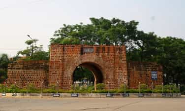
Mac Dynasty Citadel Relics (Tuyen Quang Citadel)
Tuyen Quang Citadel (also known as Mac Dynasty Citadel) is located between Xuan Hoa and Tam Co neighborhoods, in Tan Quang ward, Tuyen Quang city, built around 1533-1548. The citadel was built in a square shape, each side is 275m long, the wall is 3.5m high, and the thickness at the top of the citadel is 0.8m. In the middle of each side of the citadel there is a semicircular door opening to the four directions east, west, south, and north. A tower was built above the door and the roof was covered with scale tiles. Inside the citadel wall, there is a small path for refueling ammunition, first aid, and transporting wounded. Bricks are made of laterite containing iron ore, which is very hard. At the outer edge of the citadel is a layer of deep, flooded moats. At the beginning of the Nguyen Dynasty, the citadel was repaired, reinforced, and built with small bricks. In the citadel, slightly to the north, there is Tho Son mountain, nearly 50m high, steep, very convenient for observing and defending when surrounded. Located on the banks of the Lo River, located on a convenient transportation axis, the terrain and structure make the citadel an important military position. There were many historical events that took place in the Mac Dynasty citadel: In 1884, ethnic people led by Lanh Chan and Doc Thinh along with Luu Vinh Phuc's army besieged the French army in the citadel from August 1884 to April 1885, blocking supply ships and digging many tunnel, use explosives to destroy it. Out of a total of 600 enemies, 200 were killed and more than 300 were injured. At dawn on August 17, 1945, under the command of the Provincial Uprising Committee, the Liberation Army and local self-defense quickly captured the provincial governor's palace, security camp, post office, and treasury department, leaving only Tuyen Quang citadel was camped by Japanese troops. On August 20, the Liberation Army both blocked the Japanese army from Ha Giang and concentrated its forces to attack the citadel, organizing a mass march to show its might. On August 21, the Japanese army was forced to surrender. On March 20, 1961, at the stadium at the foot of Tho Son mountain, Tuyen Quang people held a meeting to welcome President Ho Chi Minh to visit and work. Tuyen Quang Citadel Relics was ranked as a National Relic on August 30, 1991. Source: Tuyen Quang Electronic Newspaper
Tuyen Quang
6476 view
Rating : National monument
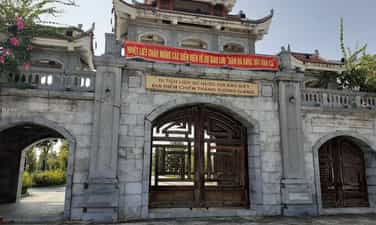
Xuong Giang Victory Site Historical Relic Area
Xuong Giang Victory Historical Site was recognized by the Ministry of Culture, Sports and Tourism as a National Historical Site in 2009; Xuong Giang ancient citadel is located in Dong Nham commune, Tho Xuong district, now Xuong Giang ward, Bac Giang city, Bac Giang province. Xuong Giang is the name of the ancient citadel built by the Ming army in the 15th century (1407). Through many ups and downs of history, only a few traces of Xuong Giang Ancient Citadel remain, but the location and appearance of the Ancient Citadel are still kept intact in the minds of every person of Bac Giang land. Therefore, in 2012, to commemorate the national heroes and educate the patriotic traditions of the homeland, the People's Committee of Bac Giang province approved the decision to build a new Xuong Giang Temple on the foundation of the ancient Xuong Giang Citadel. The campus is spacious and airy, shaded by green trees, and through the Tam Quan gate is a large festival ground. On the left side of the yard is the Ta Vu and the bell tower, on the right side of the yard is the Huu Vu and the drum tower. The center of the relic complex is Xuong Giang Temple with an area of 1.3 hectares. The system of horizontal and vertical parallel sentences is all written in the national language, and the signboard of Xuong Giang Temple is painted in red and gilded on a bright red background. Xuong Giang Temple today is the central location of Xuong Giang Ancient Citadel, built by the Ming Dynasty in 1407. After invading our country, the Ming Dynasty built defense stations and built ramparts in key places to defense. Xuong Giang Citadel then became a fortified stronghold of the Ming invaders, on the route from Guangxi (China) to Dong Quan (now Hanoi). The remaining traces show that Xuong Giang Citadel was located on a low hillock, covered with soil, surrounded by a small river and sunken fields. The citadel has a rectangular shape with a total area of 27 hectares. The citadel is divided into clear areas: mansions, barracks, food warehouses, ammunition warehouses... Xuong Giang Citadel is considered the center of the battle and had decisive significance in the Chi Lang - Xuong Giang Campaign when in 1427, Le Loi commanded the Lam Son insurgent army to attack the citadel, destroying the Ming army led by Lieu Thang. This was the decisive victory for our nation's independence in the 15th century, overthrowing the brutal rule of the Ming Dynasty that lasted for 2 decades, and opening a new page in the history of building and defending the country. glorious country of the nation. To commemorate the historic victory of the Lam Son insurgent army at Xuong Giang citadel, every year Bac Giang province organizes a festival on January 6 and 7, attracting a large number of visitors from all over. During the festival, there are many unique rituals and fun games. With typical value, on December 31, 2019, the Prime Minister ranked Xuong Giang Victory Site as a special national monument. This demonstrates the Party and State's concern for preserving and promoting the value of the nation's historical and cultural relics. Source: Bac Giang province electronic information portal
Bac Ninh
3806 view
Rating : Special national monument
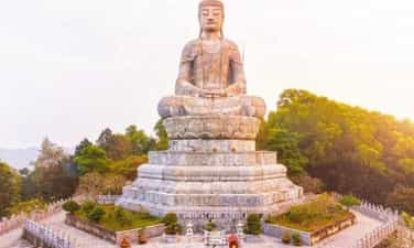
Phat Tich Temple
Phat Tich Pagoda (also known as Van Phuc Pagoda) is located on the southern slope of Phat Tich Mountain in Phat Tich commune, Tien Du district, Bac Ninh province. According to the book "Complete History of Dai Viet" and traces and relics found in the pagoda area, Van Phuc pagoda was built between the 7th and 10th centuries. Right from the beginning, Tien Son Pagoda was the gathering place and stopping place of the first missionaries from India to our country and highly enlightened Zen masters. However, it was not until the Ly Dynasty (1010-1025) that the model of living and practicing at the pagoda became clear and large-scale because at this time the pagoda became a national temple and also the homeland of the Ly dynasty kings. In 1041, Ly Thai Tong built Tu Thi Thien Phuc Institute and cast a 7,560-kg statue of Amitabha Buddha to worship. Since then, Thien Phuc Mountain or Thien Phuc Pagoda was formed, replacing the name Tien Son Pagoda. In 1057 - 1066, King Ly Thanh Tong built Thien Phuc Pagoda and erected the highest tower in the country, inside built a Buddha statue currently 1.87m high, the entire pedestal is 2.87m, cast 2 gold statues of Brahma and De Thich for worship. in front of the temple. According to history books, in 1071, King Ly went on a trip to Phat Tich and wrote the word Buddha 1 truong 6 meters (5 meters) long, and had it carved into stone to be kept at the pagoda on Tien Du mountain. There is also a story that in 1129, under the reign of King Ly Than Tong, 84,000 terracotta stupas were inaugurated, placed in many places throughout the country, 80,000 stupas were placed in Phat Tich alone, so the mountain range in Phat Tich is named Bat Van Son. From 1073 to 1210, the dynasties of King Ly Anh Tong and Ly Cao Tong all visited Thien Phuc National Temple. During the Tran Dynasty (1228 - 1400), Thien Phuc Pagoda was still the national temple but was renamed Van Phuc. In 1279 - 1280, King Tran Nhan Tong built Bao Hoa palace. After its inauguration, the king compiled Bao Hoa's poetry collection consisting of 8 volumes to commemorate. King Tran Nghe Tong (1370) built the Lan Kha library, with himself as Director, for reading, enjoying and serving the court. In 1384, the King organized a Thai student exam (PhD) here to choose talented people to serve the country. The pagoda is also the place to record the mark of a famous Chinese Zen master - Zen master Chuyet Chuyet. From 1635 - 1644, Zen Master Chuyet Cong came to practice at Phat Tich Pagoda, and Lord Trinh Trang, King Le Huyen Tong and the servants all respected him. Lord Trinh Trang wanted more Buddhist scriptures to circulate in the country, so the Zen master sent his disciple Minh Hanh to China to request the scriptures. The scriptures were brought back, some were engraved for dissemination, the rest and the engravings were stored at Phat Tich Pagoda. During the reign of Le Trung Hung (1686), the pagoda was degraded, the Le kings restored it to its old scale, calling it Phat Tich Pagoda (literally called Van Phuc). During the Nguyen Dynasty, Phat Tich Pagoda was last renovated. From 1949 - 1952, the French occupied Phat Tich Pagoda and completely destroyed this national pagoda, leaving only the brick foundation, some Patriarch statues, and a few other Dharma objects. In 1959, Phat Tich Pagoda was built by the State. Rebuilt on a small scale to preserve the remaining relics. In 2008, construction began on a number of new projects, including a 30m high stone Buddha statue (including pedestal) on Phat Tich Mountain. The newly built Amitabha Buddha statue is based on the Buddha statue carved by King Ly Thanh Tong in 1057, and is now worshiped in the main hall. Phat Tich is not only the center of Buddhism but also preserves a treasure of legends, cultural activities - folk arts, typically the legends of Mrs. To Co, the wars between An Duong Vuong and Trieu Da , the woodcutter Vuong Chat, Tu Thuc meeting a fairy, Cao Bien building an enchanted tower, the Tea Queen, Nguyen Dang Cao flower gardener and the famous peony viewing festival at Phat Tich pagoda on the 4th of the first lunar month. With the above outstanding values, Phat Tich Pagoda was recognized by the Prime Minister as a special national historical and artistic architectural monument on December 31, 2014. Source: Department of Cultural Heritage
Bac Ninh
4782 view
Rating : Special national monument

Cha citadel relics
In its golden age, the city was called Buddha Tathagata, the capital city of the capital Vijaya. This is one of the four ancient Champa citadels in Binh Dinh, once the economic and political center of this area from the 8th to the 15th century. Cha Citadel is located south of the Vijaya citadel, now in the territory of An Thanh village, Nhon Loc commune, An Nhon district - Binh Dinh. Located on a high strip of land on the south bank of the Kon River, Cha Citadel consists of two large and small citadels built close to each other (also known as the inner citadel and outer citadel), both with a rectangular plan. In the large citadel area, pairs of citadel walls face each other with negligible length differences. When building, the ancients relied on the direction of the Kon River, so the length of the northern wall was about 100m longer than the southern one. The east and west pair of walls are nearly 350m long, while the north and south pair of walls are nearly 950m long. Except for the north side of the citadel, which was mostly eroded due to its proximity to the Kon River, the remaining sides are relatively intact. In the northwest corner of the citadel area, there are also traces of a rectangular campus, surrounded by a brick mound in which a very large number of remaining bricks and tiles with thresholds and door pillars of different sizes are found. large, especially with many yin-yang bricks and roof tiles - decorative architectural materials only found in the old capital of Champa like Tra Kieu. In this area, people discovered a beautiful bust of the goddess Kabera Yakshini along with elaborate reliefs made of terracotta, proving the real existence of an architecture. urban. The small citadel is located back-to-back with the large citadel in the northwest direction, with a width of 134m and a length of 240m. An interesting thing here is that the creator of this ancient Buddhist citadel deliberately arranged two large and small citadels in a continuous pattern, shown in the fact that the eastern wall of the small citadel is also a part of the wall. To the west of the big citadel, another section is added. In this small citadel, no trace of the wall was found on the north side and it used the Kon River as a moat to create a shield to protect the citadel. This shows that the small citadel was arranged by ancient people as an outpost of the large citadel, a very important waterway transportation route. Citadel Cha is a citadel that also has many other names in folk culture such as Citadel Hoi, Citadel Ho Xu, Citadel Bac, Citadel Cu... but the most common name is Citadel Cha. The large citadel is located to the east. The north side of the wall runs west-east, 947m long, 3 to 5m wide, and currently about 1m high. In the middle of the citadel wall, there is an 8m high mound, gradually sloping towards the two sides of the citadel, called the Flag Pillar Mound. The southern wall has a similar length, but has been eroded, remaining only slightly above ground level. The most visible relics are the two eastern and western walls. The eastern wall runs north-south, is 345m long with an average height of 4m, and the wall is over 30m wide. The western wall has the same length and height, but the surface is narrower, about 7 to 10 meters. The northwest corner of the large citadel is surrounded by two sections of the citadel wall, one running from the Flagpole mound to the south with a length of 240m and a section perpendicular to it running to the west, connecting with the western wall of the large citadel to form a rectangular campus. In the middle of this campus there is a large mound of bricks, the remains of a collapsed structure. The smaller rectangular citadel is located adjacent to the northwest of the large citadel with a length of 440m and a width of 134m. Thanh Cha Relics was ranked a national historical and cultural relic by the Ministry of Culture, Information and Sports on November 27, 2003. Source: National Museum of History
Gia Lai
7357 view
Rating : National monument