
 vn
vn en
en ja
ja ko
ko zh
zh





















List of relic sites (1440)

Cha citadel relics
In its golden age, the city was called Buddha Tathagata, the capital city of the capital Vijaya. This is one of the four ancient Champa citadels in Binh Dinh, once the economic and political center of this area from the 8th to the 15th century. Cha Citadel is located south of the Vijaya citadel, now in the territory of An Thanh village, Nhon Loc commune, An Nhon district - Binh Dinh. Located on a high strip of land on the south bank of the Kon River, Cha Citadel consists of two large and small citadels built close to each other (also known as the inner citadel and outer citadel), both with a rectangular plan. In the large citadel area, pairs of citadel walls face each other with negligible length differences. When building, the ancients relied on the direction of the Kon River, so the length of the northern wall was about 100m longer than the southern one. The east and west pair of walls are nearly 350m long, while the north and south pair of walls are nearly 950m long. Except for the north side of the citadel, which was mostly eroded due to its proximity to the Kon River, the remaining sides are relatively intact. In the northwest corner of the citadel area, there are also traces of a rectangular campus, surrounded by a brick mound in which a very large number of remaining bricks and tiles with thresholds and door pillars of different sizes are found. large, especially with many yin-yang bricks and roof tiles - decorative architectural materials only found in the old capital of Champa like Tra Kieu. In this area, people discovered a beautiful bust of the goddess Kabera Yakshini along with elaborate reliefs made of terracotta, proving the real existence of an architecture. urban. The small citadel is located back-to-back with the large citadel in the northwest direction, with a width of 134m and a length of 240m. An interesting thing here is that the creator of this ancient Buddhist citadel deliberately arranged two large and small citadels in a continuous pattern, shown in the fact that the eastern wall of the small citadel is also a part of the wall. To the west of the big citadel, another section is added. In this small citadel, no trace of the wall was found on the north side and it used the Kon River as a moat to create a shield to protect the citadel. This shows that the small citadel was arranged by ancient people as an outpost of the large citadel, a very important waterway transportation route. Citadel Cha is a citadel that also has many other names in folk culture such as Citadel Hoi, Citadel Ho Xu, Citadel Bac, Citadel Cu... but the most common name is Citadel Cha. The large citadel is located to the east. The north side of the wall runs west-east, 947m long, 3 to 5m wide, and currently about 1m high. In the middle of the citadel wall, there is an 8m high mound, gradually sloping towards the two sides of the citadel, called the Flag Pillar Mound. The southern wall has a similar length, but has been eroded, remaining only slightly above ground level. The most visible relics are the two eastern and western walls. The eastern wall runs north-south, is 345m long with an average height of 4m, and the wall is over 30m wide. The western wall has the same length and height, but the surface is narrower, about 7 to 10 meters. The northwest corner of the large citadel is surrounded by two sections of the citadel wall, one running from the Flagpole mound to the south with a length of 240m and a section perpendicular to it running to the west, connecting with the western wall of the large citadel to form a rectangular campus. In the middle of this campus there is a large mound of bricks, the remains of a collapsed structure. The smaller rectangular citadel is located adjacent to the northwest of the large citadel with a length of 440m and a width of 134m. Thanh Cha Relics was ranked a national historical and cultural relic by the Ministry of Culture, Information and Sports on November 27, 2003. Source: National Museum of History
Gia Lai
8202 view
Rating : National monument
Vietnam - Laos revolutionary historical relic site
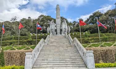
The Vietnam - Laos revolutionary relic site in Lao Kho village, Phieng Khoai commune, Yen Chau district, Son La province is a place, a beautiful symbol of Vietnam - Laos military and people love in the anti-colonial resistance war. France. This is also one of the first revolutionary bases along the Vietnam - Laos border, which left a strong impression on the help of the people in the region to the Commander of the Laos - North Volunteer Committee (Laos). ) is President Kaysone Phomvihane. Today, this relic has become a famous tourist destination attracting people from both countries to visit and learn. Located close to the border, Lao Kho village has a very important geographical position, bordering the West and South with Xieng Kho district, Hua Phan province (Laos); The rugged terrain, high mountains, many deep valleys, and dense forests, were favorable conditions for the stationing of troops and secret activities of guerrillas during the resistance war against the French colonialists. On May 20, 1948, the Northern Laos Assault Committee was instructed to establish by the General Command of the National Army and Vietnam Militia. The Northern Laos Campaign Committee was headed by comrade Kaysone Phomvihane (later General Secretary of the Lao People's Revolutionary Party, Prime Minister, and President of Laos). guerrilla movement to establish resistance bases against the French colonialists and train local cadres. The Northern Laos Volunteer Committee chose Phieng Sa village, Chieng On commune, Yen Chau district, Son La province as a base, preparing all conditions to carry out the mission. Here, the people of Phieng Sa village and Mr. Trang Lao Kho's family supported and shared food to feed the revolutionary cadres, helping comrade Kaysone Phomvihane and the Northern Lao Volunteer Committee step by step advance deeper into inland Laos, building bases, developing forces, contributing to the development of the resistance war of the Lao tribal people. Phieng Sa village, Chieng On commune, now Lao Kho village, Phieng Khoai commune, has become a place with many imprints of the fighting solidarity alliance, a symbol of the special relationship between the two countries and two peoples of Vietnam. - Laos. Another honor that the people in Lao Kho village as well as Mr. Trang Lao Kho's family are extremely proud of is that on March 19, 2010, the Lao People's Democratic Republic awarded the Medal of Freedom. III class and Friendship Medal. This has shown the deep gratitude of the Party, State and people of Laos to the Party, State and people of Vietnam in general, and Lao Kho village in particular. With international value and outstanding history of the revolutions of the two countries of Vietnam and Laos, on April 3, 2012, the Vietnam - Laos Revolutionary Historical Relic in Lao Kho village was recognized by the Ministry of Culture, Sports and Tourism. Vietnam Tourism is ranked as a National Historical Relic. By August 29, 2022, the Vietnam-Laos Revolutionary Historical Relic Area was ranked as a special national relic. In order to preserve revolutionary relics during the resistance war against the French colonialists, it is a place to review historical traditions, remember the gratitude of the generation of fathers and grandfathers in the process of liberating the people of Vietnam - Laos, contributing to stability. politics, maintaining security and border sovereignty, improving the lives of ethnic minorities. In order to promote relics associated with tourism development, the National Assembly of the two countries decided and directed the construction of the Vietnam - Laos Revolutionary Historical Relic Area in Lao Kho village. Since then, the relic site has been a place to introduce and honor great historical values, good traditional relationships between the two peoples, affirming the noble international spirit and great sacrifices. of the Vietnamese army and people for the Lao people. Source: Son La province electronic information portal
Son La
7119 view
Rating : Special national monument

Muong Bam Tower
Muong Bam Tower, also known as That Ban Lao, is an architectural and artistic relic in Lao village, Muong Bam commune, Thuan Chau district, Son La province, Vietnam. Muong Bam Tower was ranked as a national historical relic by the Ministry of Culture, Sports and Tourism on October 24, 2012. This is an architectural and artistic relic of the Lao people built in the 16th century. Muong Bam Tower is ancient, mossy, and quiet on a hill at the beginning of the commune. Located on a hill overlooking the Nam Hua River, which in Thai means "headstream" of the Ma River. The tower is 4 floors high, built in the shape of a 13 m high tower. Standing from the tower, you can see the entire Muong Bam commune with the Nam Hua stream winding like a big snake and the surrounding rolling mountains. The people in Muong Bam are mainly Thai, Kho Mu, and H'Mong ethnic people. According to the elders in the village, more than 500 years ago, this was a land with beautiful scenery, favorable geography, with a long mountain range, in front was the Nam Hua stream flowing through, rice fields following the stream. heating. According to feng shui theory, this is a beautiful and stable land. Here half a century ago, the Lao and Thai tribes lived together peacefully and worked hard to do business. Muong Bam Tower is also called "That Ban Lao" (That in Lao means Tower). The tower is located in the center of the village, where many Lao ethnic people in the commune live. The Tower's architecture bears bold architectural features of the Lao people. Therefore, people here often call it Lao Ban Tower. The tower consists of a complex of 5 towers, a large tower in the middle and 4 smaller towers next to the big tower. The Tower's face overlooks the confluence of the long, winding Nam Hua stream, with mountain blocks as a screen, mountains blocking both sides to act as thrones, behind the Tower there is a mountain range that looks like a person sitting "meditating". The Tower complex has a very quiet and majestic position. All 5 towers are built with a main material of red bricks, bonded together with lime, sand, and molasses. The patterns are made of embossed stucco, and in many places decorative terracotta shapes are attached. The big tower is also called the Mother Tower, 13 m high, divided into 4 floors. Decorated mainly with patterns of Elephants, Tigers and dancing Female Statues, leaves bent in the shape of clouds, chrysanthemum patterns, stylized lemon flowers, "rosary" patterns, Naga 5 "magic snake" images head, a downward-facing lotus shape, etc. All of these patterns are embossed on the gradually shrinking base. The entire body looks like a blooming lotus bud from afar. The small towers are 3.7m high, located 3m away from the big tower, built with identical architecture and decorative patterns. Small Tower, also known as Small Tower, is divided into 4 floors. Decorated mainly with leaf patterns alternating with cloud patterns, chrysanthemum strings and gerbera flowers. The 4 sides of the base of the tower are covered with 4 raised leaves, large enough to hug the 4 corners, inside there are 2 hidden threads running parallel. The top of the tower gradually shrinks, soaring into the sky. Currently, the relic remains a large tower (mother tower) and a small tower (child tower). Besides the big tower, there is also a statue of "gods" right at the foot of the tower that has been completely broken (only the pedestal remains). Muong Bam Tower along with the system of Pagodas and Towers in the Northwest region such as: Muong Luan Tower (Dien Bien Dong), Muong Va Tower (Sop Cop district, Son La province) Chien Vien Pagoda (Vat Hong Pagoda - Moc Chau district , Son La province) Muong Bam Tower (Thuan Chau district - Son La province) is a unique Buddhist pagoda and tower architecture belonging to the Theravada sect. According to the old people in the story, in the past, in the Tower area every year in April of the solar calendar, a "rain praying ceremony" was held for the new crop. Over the years, the Lao tribe moved to other places to live. Currently, there are no longer festivals held here. According to the assessment of the cultural sector, the uniqueness of the tower, in addition to its shape, also includes the materials used to build the tower. Source: Son La province electronic information portal
Son La
7414 view
Rating : National monument

Moc Ly Fort Historical Site
Moc Ly Fort was built by the French colonialists in 1951 in Moc Chau. The post is located on an independent rocky mountain, the terrain is dangerous, there are many vertical cliffs blocking the intersection from Hanoi to the Northwest, from Vietnam to Upper Laos with the purpose of preventing our troops from attacking. liberated the Northwest and Upper Laos. They were equipped with dense firepower, so Moc Ly station was nicknamed: "The iron armor" that was inviolable in the Son La division. Moc Ly Fort was commanded by the military officer Phap Vanh - Xang, who had more than one Thai battalion reinforced. In addition to being fully equipped with personal weapons such as submachine guns and rifles, the station is also equipped with a 94 mm cannon, 6 81 and 60 mm mortars, 3 machine guns, 27 medium machine guns, food, and weapons. Regularly replenished to ensure long-term combat. This is a very important key position, so General De-Ly-Na-Rate personally came here to check the defense arrangements and assign tasks to officers and soldiers to defend to the end when attacked. . The French military command also withdrew from Phat Diem (Ninh Binh) to reinforce Fort Moc Ly. Groups of commandos and villains were carefully selected and trained to launch operations in areas they suspected were hidden bases. my army. In early September 1952, our people's resistance war against the French colonialists began to enter a new phase. The Politburo and President Ho Chi Minh decided to open the Northwest campaign. The Party Central Committee's policy is "Avoid strong places, attack weak places, find the enemy's loopholes to attack" and the direction of attack is Northwest. With determination to destroy enemy forces and take advantage of the people's strength, destroy the fake "autonomous Thai land" of the French colonialists, liberate the Northwest, strengthen the Viet Bac base, maintain the Laos - Yunnan (China) international traffic route, and create conditions for developing network of Laos, isolating and disrupting the enemy's rear. Therefore, the capture of Moc Ly station for our army and people had a very important meaning, it determined the deployment of logistics for the campaign from Hoa Binh to the Northwest. At this time, our main troops had advanced deep into the enemy's rear area. Therefore, ensuring food, food, and weapons is one of the urgent issues of primary importance in deciding combat plans. Therefore, on November 17 and 18, 1952, units secretly dug fortifications and occupied the battlefield. Battalions 249 and 888 moved through the forest along the stream to the Northwest to form a siege to block enemy reinforcements from Son La. According to the plan of the Northwest Campaign Command, on November 19, 1952, our troops tightened the siege around Moc Ly post. After exactly 3 hours of extremely fierce fighting, the battle at Moc Ly post ended successfully. We destroyed and captured 350 people, including one (officer Vanh - Xang and a number of officers) and confiscated more than 500 guns of all kinds and the entire warehouse of weapons, military equipment, military supplies and food. , liberating over 1,000 people. Coordinating with the main army, the guerrilla teams of Tu Nang, A Ma, Chieng Khua, and Pa Hang organized a siege to attack Pa Khom and Pa Hang stations. The enemy panicked and quickly opened a retreat to Yen Chau and Laos. After liberating Moc Chau, Group 316 divided into 3 army wings to continue advancing to liberate Moc Chau and Son La. On December 10, 1952, the Northwest campaign ended with a decisive victory. The victory at Fort Moc Ly had a very important meaning in the resistance war against the French colonialists of our army and people. We have connected the road from Hoa Binh to Son La, creating favorable conditions for the liberation of the Northwest and Dien Bien Phu, preventing and cutting off enemy traffic to Upper Laos. Besides, the victory at Moc Ly Fort also has a strategic military significance. Our army and people learned from the experience of fighting fortified fortresses that they must attack from above and attack from above. During the battle at Moc Ly Fort, 53 soldiers of Regiment 174, Division 316 heroically sacrificed their lives. To commemorate the great contributions of the martyrs, the Party, State and people of all ethnic groups in Son La built a memorial stele house engraved with the names of 53 martyrs. Today, Fort Moc Ly Historical Site is a place of traditional education for the people, especially the young generation of Son La province. With that meaning and importance, Fort Moc Ly Historical Relic was ranked Nationally by the Ministry of Culture and Information on January 20, 1998. Source: Electronic information portal of the Ministry of Culture, Sports and Tourism
Son La
7587 view
Rating : National monument
Co Noi Junction historical site
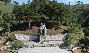
Co Noi intersection (Mai Son district, Son La province), a historical place, a brilliant milestone engraved with a period of heroic fighting of the Vietnam Youth Volunteer Force in the Holy Nineteenth Resistance War. years against French colonialism. During the Dien Bien Phu campaign, Co Noi intersection was the most important intersection for the advance of our army and people participating in the Dien Bien Phu campaign. This location became the "Red Spot" for the French colonialists to bombard most fiercely, in order to block and destroy the traffic arteries of our army and people. One day here, they threw about 69 tons of bombs to plow and destroy, but under the rain of enemy bombs, the armed forces and Youth Volunteers throughout the country bravely held on, day and night still ensuring communication. Traffic arteries still flow evenly on the fire line. During the Dien Bien Phu campaign at Co Noi Junction, 100 soldiers and Youth Volunteers sacrificed their lives. In December 1952, the Party Central Committee and President Ho Chi Minh decided to open the Dien Bien Phu campaign, expand and consolidate the liberated area to prepare for the campaign, tens of thousands of soldiers, citizens, and young people volunteered everywhere. Localities were mobilized to the Northwest battlefield. In this historic campaign, Son La played a very important role as both a large rear base near the battlefield and a gateway to the Northwest. Son La covers the main traffic routes connecting the Northern Delta and the Viet Bac war zone; Inter-region III and IV with Dien Bien Phu battlefield. Among them, Co Noi intersection is the most important intersection, considered a "throat" on the fire line. This intersection is the intersection of two national highways, 13A (current national highway 37) and 41 (current national highway 6), in Co Noi commune, Mai Son district. The terrain here is rugged, surrounded by rolling mountains, forming a narrow and deep valley more than 2 km long. All support activities of weapons, food, and food of our army and people from the rear of Viet Bac and inter-regions III and IV to the Dien Bien Phu battlefield must pass through this gate. In his memoirs, General Vo Nguyen Giap affirmed: "Co Noi intersection is a gate, all those who go to war must pass." With that important strategic location, Co Noi intersection has become a "bomb bag", one of the most fierce targets of the French air force in Son La area. They believe that blocking and cutting off transportation and supply routes in all aspects of the Northern rear for the Dien Bien Phu battlefield is a matter of survival for the French expeditionary army in Vietnam. With the spirit of the whole country serving the Dien Bien Phu campaign, the slogan throughout the campaign of our army and people was: "Everything for the front line" "Everything for victory". The people of the provinces took turns sending their children off enthusiastically to join the army, become youth volunteers and frontline civil servants. The battle on the supply, transportation, and mine clearance fronts to ensure transportation and communication took place urgently and fiercely from the opening day to the end of the campaign. To be eternally grateful to the heroic youth volunteers who fought and sacrificed for the independence and freedom of the Fatherland at Co Noi intersection. On April 21, 2000, the Central Committee of the Ho Chi Minh Communist Youth Union and the People's Committee of Son La province began construction of a group of monuments commemorating martyrs of young volunteers at the location of the "fire coordinates" in the past. area of 20,000m2. The project was inaugurated on May 7, 2002, the group of statues includes 3 young volunteers in different positions made from granite. The statue is 12 meters high, placed on a pedestal of a stone block weighing 280 tons. Along with the group of monuments, there are also two reliefs showing the image of the entire people going to battle against the French colonialists. Each relief has an area of 42 square meters, weighs 52 tons, and is covered with metal, recreating the image of our army and people enthusiastically supporting the Dien Bien Phu battlefield, demonstrating the indomitable will of the youth force. Vietnamese title "Determining to die for the Fatherland and deciding to live". On the occasion of the 50th anniversary of the historic victory of Dien Bien Phu (1954 - 2004), the relic was ranked as a national historical relic by the Ministry of Culture and Information (now the Ministry of Culture, Sports and Tourism). . Source: Mai Son district electronic information portal
Son La
7399 view
Rating : National monument

Ban Keo Hill
Ban Keo hill is located in the northwest of the stronghold group. The French colonialists gave Keo village a new name as the Anno Mari resistance center. This base is located next to Keo village - a village of Thai ethnic people, so it is called Keo hill. In Thai, Keo means a small "Thung" at the foot of the mountain. Here there is a large beach near the foot of the mountain (currently soldiers often use it as a training ground). Ban Keo hill is not very high but quite long, shaped like a crescent moon, concave and facing the northern mountains. Along with Doc Lap Hill, Keo village is responsible for protecting Muong Thanh airport, preventing attacks by our troops from the direction of Lai Chau to Dien Bien Phu. Here, the French army arranged a quite solid defensive fortification system. In addition to the fortified battlefield, they also use barbed wire fences surrounding the base. Opening the first attack, on March 13, 1954, we destroyed the Him Lam base. On March 15, 1954, we destroyed Independence base. At this time, Ban Keo base had become isolated, under strong threat from our troops, those reluctant puppet soldiers were in a very tense mood and during the 2 days of the battle, the Thai soldiers witnessed The rapid collapse of the two strongest resistance centers, protected by French European and African units considered to be fierce, saw with their own eyes how soldiers, even when going to the rescue, were beaten to pieces in their vehicles. Bloodied monks from Doc Lap fled to Muong Thanh, and now they had to consider a way out, they saw the strength of the Viet Minh. The Viet Minh had big artillery and a mighty army. The Viet Minh had artillery trucks. Just appearing on the field was a strange event never seen before in the war at Dien Bien Phu. The 36th Regiment of the 308th Infantry was assigned to destroy Keo village. The 36th Regiment realized that it had the ability to solve this stronghold without a battle, so it used a single-army order to call on the Thai soldiers to surrender. On March 16, 1954, at the foot of Ban Keo hill, a large picture-like scene appeared of a group of Thai soldiers leaving their positions with the words: "Return to the Fatherland, with your compatriots, you will received a kind welcome." Although the French commander tried to control him, the Thai soldiers took advantage of the time the French commander went underground to hide, brought out their weapons, and pulled out the line. The French sent tanks to chase the Thai Wei army and artillery. of the Viet Minh fired to cover the above-mentioned soldiers running to safe shelter positions in the forest. Without firing a shot, the 36th Regiment captured Keo village, ending the first attack, opening the northern door to the center of the Dien Bien Phu stronghold. Source: General electronic information portal of the Department of Culture, Sports and Tourism of Dien Bien province
Dien Bien
6924 view
Rating : National monument

Independence Hill
Independence Hill is a component relic of the Dien Bien Phu Battlefield Special National Monument. Doc Lap Hill has another name: Pu Vang (Victory Hill). Located right at the foot of Pu Vang is Tong Khao field, a sunken field. In the past, the Phe invaders captured all the children in the area and killed them. Children who are still infants are put in a mortar and pounded. Children who are toddlers or older are thrown into this low field and then drained to die. When the field dried up, children's bones were white all over the field, from then on this field was called Tong Khao (local language meaning field of white bones). At Tong Khao field, according to local people, there are also traces of the victory of the insurgent leader Hoang Cong Chat who came from the lowlands to wave the insurrection flag. The leader was assisted by the Thai ethnic people, typically General Ngai and General Khanh, in the fight against Phe enemy general Pha Chau Tin Toong in Tam Van citadel. The insurgents chased the Phe invaders up to the foot of the hill and destroyed all the enemy troops, beheading the enemy general in 1754. During the 1954 Dien Bien Phu campaign, the French Army named this base Gabrielle. Doc Lap is the name given to this base by the People's Army of Vietnam because the hill stands separately in the middle of a flat area in the north of Muong Thanh field. On November 20, 1953, French troops parachuted to occupy Dien Bien Phu and then built Dien Bien Phu into an unprecedented stronghold in Indochina. Gabrielle base, located on Muong Thanh hill, 500m long, 200m wide, is one of the most fortified resistance centers of the Dien Bien Phu base group, in the North division, about 4km from Muong Thanh center. . Doc Lap resistance center, along with two resistance centers Him Lam and Ban Keo, form a powerful outer defense area to the North and Northeast of the stronghold Group Center. As for the Vietnamese Army, during the Dien Bien Phu Campaign, the task of attacking Doc Lap Hill was assigned to the 88th Regiment, 308th Infantry commanded by Regimental Commander Bui Nam Ha and the 165th Regiment, 312th Infantry led by Lieutenant General Bui Nam Ha. Group leader Le Thuy commanded. The two units were reinforced with 4 105mm guns, 4 120mm mortars, 4 75mm mountain guns and were under the command of 308th Company Commander Vuong Thua Vu. Regiment 165 took on the main offensive, breaking through from the East-South direction, attacking along the length of the base. Regiment 88 took charge of the secondary attack to break through from the East-North direction, and at the same time organized a return mission in the West and arranged forces to block reinforcements from Muong Thanh. The victory on Doc Lap base was the second biggest victory after the Him Lam victory, creating a very good spirit for the soldiers of the Vietnamese Army to fight and win in the next battles. The victory at Doc Lap base opened the way to the central Muong Thanh subdivision, the Vietnamese Army destroyed and wiped out the elite Le Duong units of the French army. Currently, Doc Lap Hill Relic is one of 45 component relic sites belonging to the Special National Historical Site of Dien Bien Phu Battlefield. Restoration and renovation work is expected to be carried out in the near future to meet the sightseeing, learning and research needs of domestic and international tourists, becoming an official tourist destination on their travel itinerary. calendar, learn about the history of tourists when coming to Dien Bien province. Source: General Electronic Information Portal Department of Culture, Sports and Tourism of Dien Bien Province
Dien Bien
7023 view
Rating : National monument
Temple of Truong Han Sieu
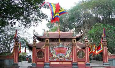
Truong Han Sieu Temple is located in the southwest of Duc Thuy Mountain, one side leans against the mountain, below is the lyrical Day River lazily flowing, winding from right to left, embracing the Temple area, creating a lyrical scene. , peaceful yet majestic. Truong Han Sieu (year of birth unknown) is from Yen Ninh district, Truong Yen district, now Ninh Binh city, Ninh Binh province. He was talented in literature and martial arts, rich in patriotism, and was respected by the kings of the Tran dynasty. Together with Nguyen Trung Ngan, he composed the Code of Laws "The Thuong Thu" and the book "Royal Trieu Dien", laying the foundation for the Vietnamese feudal regime to operate according to the law. When he died, he was posthumously awarded the title of Deputy Thai Viceroy and worshiped at the Temple of Literature - Quoc Tu Giam. When he died, a temple was built in the Southeast near his grave. But over time due to war, Truong Han Sieu temple was leveled. In early 1993, during the construction of houses in Van Giang ward, city residents discovered stone tablets and stone steles, column bases, and stone steps of the temple buried deep in the ground. On April 24, 1998, the construction of Truong Han Sieu temple officially started in the southwest area of Duc Thuy mountain. Truong Han Sieu Temple has a nail-style architecture, including 3 Bai Duong compartments and 2 Harem compartments, two floors of roofs covered with taro tiles, and the corners have curved knife heads. Looking at the edge of the roof, it rolls up at both ends like the image of a spectacular dragon boat. On the roof of the temple are two dragons flanking the moon. The front of the temple has a large inscription in Chinese characters "Truong Thang Phu Tu". Inside the altar is a bronze statue of Truong Han Sieu with a 1:1 ratio, sitting on a pedestal in Tran Dynasty costumes. The altar has a hammock door, an incense burner and two shelves with precious bowls on both sides. The last room of the harem has an incense burner to hold Truong Han Sieu's tablet. Every spring, Truong Han Sieu Temple is also a place where a large number of people in the province come to burn incense, sincerely ask for the New Year's blessing, with wishes for good things and luck in the new year. Truong Han Sieu Temple is located right next to Non Nuoc Mountain, one of the most famous tourist destinations in Ninh Binh. The temple worships Truong Han Sieu - a cultural celebrity and also a son of Ninh Binh. He was a man of "literature and martial arts", and together with scholar Nguyen Trung Ngan, composed the "Hinshu" law code. The Temple of Truong Han Sieu will always be living documents for generations to come. If you visit the ancient capital, don't forget to visit Truong Han Sieu temple to learn more about the roots of Vietnamese history. Future generations need to preserve cultural relics of historical significance because this is not simply preserving ancient architecture but is also related to the cultural history of an entire nation. Source: Electronic information page of Ninh Binh Department of Tourism Information Center
Ninh Binh
7043 view
Rating : National monument
HISTORICAL RELIC OF LINH SON CO MIEU
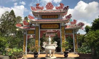
Linh Son Ancient Temple is located at Thoi Hoa 1, Thoi Long Ward, O Mon District. This is not only the belief base of the Chinese people but also a solid Chinese foundation, contributing to protecting the revolution in the two resistance wars against foreign invaders. According to the elders, after a group of Chaozhou Chinese people came to Thoi Hung village (now Thoi Long ward) and saw the fertile land, they settled down to make a living here. In 1890, people decided to build the first temple made of leaves to worship Quan Thanh De, and at the same time create conditions for contact with Chinese groups far away from their homeland. In 1930, the temple was rebuilt firmly with wood and the roof was covered with yin and yang tiles. Later, it was renovated many times in 2002 and 2004, making the temple more and more spacious and carrying a certain aesthetic value. Linh Son Co Mieu is located on an area of 517.5 m2 and was built in the national-shaped architectural style, with rows of houses arranged perpendicular to each other including: front hall, natural yard, main hall, on the left of the temple is the state house. details, on the right is the gate to the Chinese cemetery, creating a space in the middle called Thien Tinh yard. The temple is surrounded by a fence with iron bars, the main side facing Bang Tang canal. On both sides of the door are a pair of tureens praising the saints worshiped at the Temple: “A thousand years of righteousness and bravery are unmatched. The eternal star is the number one person". The walls inside the Temple are decorated with paintings of Chinese classics, natural landscapes... creating a feeling of closeness and solemnity in the place of worship. The truss system is supported by 4 circular columns embossed in the shape of dragons called dragon pillars. Between the front hall and the quiet courtyard is a pair of "torches and cranes". Next is the Thien Tinh courtyard, the main hall decorated with blue "two dragons flanking the tai chi", below is a screen decorated with lions, mountain and river scenes, apricot, orchids, chrysanthemums, and bamboos symbolizing warm wishes. full, peaceful, happy. The main object of worship at Linh Son Co Mieu is Quan Thanh De Quan; In addition, Linh Son Co Mieu also worships the Earth God, the First Sage, the Later Sage... The worship statues at the Temple are carved in the style of round statues, very simple and rustic, expressing personality through each character's facial expressions, both close to mortals, while also carrying the majesty of the divine world. The architectural style and festivals at Linh Son Co Mieu have contributed to reflecting the typical folk culture of the Chinese people in Can Tho city. From 1950 - 1975, the main hall of Linh Son Co Mieu was also used as a meeting place for revolutionary cadres. Under the altar of the gods is a secret vault that can accommodate 4-5 people. The cellar door is right in the middle of the altar, previously disguised as the Earth God altar. Behind the wooden wall of the back office is also the exit to the cellar disguised by a hibiscus fence. Although many times suspicious enemies came to search everywhere in the Temple, thanks to skillful camouflage and the support of Chinese people, the revolutionary cadres were safely protected. Therefore, Linh Son Co Mieu is not only a religious base but also a historical relic recording the revolutionary struggle of the Chinese people in Can Tho. Linh Son Co Mieu was ranked as a historical relic by Can Tho City People's Committee on March 31, 2008. Source: Can Tho City People's Committee
Can Tho
6957 view
Rating : City-level relics

Am God
Am Chua is located on Dai An mountain, also known as Qua Son (Qua Lanh, Chua mountain, Cam mountain), the most common name Dai An in the past. Nui Chua is a mountain, 284 meters high. Am Chua is located halfway up the mountain, 80 meters above sea level, in Dai Dien Trung village, Dien Dien commune, Dien Khanh district, Khanh Hoa province. Up to now, there are no documents determining the specific time that Am Chua was built; But according to the story of local elders, Am Chua initially was a small hermitage located next to Dai An mountain pagoda on Hoa Son mountain and after many restorations, the hermitage became a place to worship Thien Y Thanh. The model is as spacious as today. Although the small pagoda named Dai An no longer exists, the blend of Mother Goddess worship and Buddhist rituals is still intact and is a typical cultural feature at Am Chua. The architectural system of worship at Am Chua has many similarities with the architecture of communal houses in Khanh Hoa. The worship structure has a coordination of worship and sacrifices that is similar to religious architectural works in the province and this is a religious feature of Khanh Hoa people. Architectural works at Am Chua include: Three gates, Mr. and Mrs. Tieu's tombs, inscriptions, Son Lam temple, Ngu Hanh temple, main hall. The main hall was restored for the third time in the year of the Dog (1958), the 4th time in the year of the Dragon (1988), and a major restoration in the year of the Ox (2009) with a three-room architectural form. The God Temple is decorated with altars, pairs of opposing tureens, and diaphragms carved delicately and sharply. The first altar is an incense altar worshiping the deity of Lady Tieu. The sacred altar of Thien Y Thanh Mau is splendidly decorated and is the most concentrated point of the worship structure in the Main Hall; On both sides are shrines worshiping the Six Immortals and the Twelve Immortals. On the left of the altar to worship the Holy Mother is the altar to worship the Four Crown Princes and the Twelve Executives, also known as the altar to Uncle (Prince Tri - son of the Holy Mother); On the right is the altar worshiping the Six Immortals and the Twelve Immortals, also known as the altar for the Lady (Princess Quy - daughter of Thanh Mau). All altars in the main hall are made of precious wood, carved with delicate and unique patterns and motifs. The entire main hall has a truss-style roof structure, rows of main columns and military columns made from highly valuable precious wood. Am Chua still retains two titles bestowed by the Nguyen Dynasty kings. According to folk beliefs, March is the month of Via Ba, "August is the anniversary of father's death, March is the anniversary of mother's death". Am Chua Festival is from the 1st to the 3rd day of the third lunar month every year and takes place according to a traditional process: Moc Duc (statue bathing) ceremony, Tam Hien Luong ceremony, main sacrificial ceremony, Van Mau singing, offering Female officials, Hau Thuong worshiping ceremony, incense offering ceremony and shadow dance. Through legends and folk tales, worship shows the continuity of culture and beliefs. Am Chua has brought within itself the values of the two cultures of Cham and Vietnam. Although there are different imprints, it must be affirmed that the image of Thien Y A Na is a Vietnamese creation, originating from the image of Po Nagar of the Cham people and originating from the image embodying the mother. creation of all species. With its tangible and intangible cultural values, in 1999 Am Chua was ranked by the State as a National Historical-Cultural Monument. Source: Ho Chi Minh Communist Youth Union, Khanh Hoa province
Khanh Hoa
7013 view
Rating : National monument
Memorial area of Dr. Alexandre Yersin
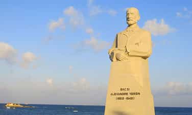
The memorial historical relic of scientist Alexan Dr Yersin was ranked as a National Monument by the Ministry of Culture, Information, Sports and Tourism on September 28, 1990. The relic is a complex of individual, typical, outstanding locations, directly linked to the life and career of scientist Alexan Dr Yersin, including 3 locations, which are the library at the Pasteur Institute of Nha Trang ( Tran Phu Street, Xuong Huan Ward, Nha Trang City), Linh Son Pagoda, Alexan Dr Yersin's grave (Suoi Cat Commune, Cam Lam District). Dr. Alexan Dr Yersin was born on September 22, 1863 in Switzerland. At the age of 20, he graduated from the University of Paris (France). In 1886, he worked at the Pasteur Institute in Paris and collaborated with Dr. Roux to find toxins. leukemic bacteria. In 1890, he was granted French citizenship. After he achieved certain successes in the medical field, Yersin suddenly left the field of microbiology - living a life of sailor and explorer - starting another life lasting 50 years. In 1891, he resigned from Messageries and went to Indochina to work as a physician for the Messageries shipping company to fulfill his dream of exploring new horizons. In July 1891, he came to Nha Trang for the first time. In 1895, Yersin founded the Nha Trang Pasteur Institute and prepared serum to cure the plague. A year later, the epidemic relapsed in China. Yersin went to China again and saved many people from the dangerous disease that killed 50 million people in ancient times. By the end of 1899, he returned to Nha Trang and established the Pasteur Institute. For nearly 50 years of living alone in Nha Trang, he devoted his entire life to his scientific career, successfully researching the production of medicine to cure the plague on June 20, 1894. Because he lived relatively simply and was close to the people of Con village, he was very loved by everyone. After that, he spent about two years (1902-1903) going to Hanoi to open the Indochina Medical College and become the first principal there. In 1924, he held the position of Inspector General of the Pasteur Institutes in Indochina. In 1933, he became honorary director of the Pasteur Institute in Paris. On June 28, 1935, Yersin High School was inaugurated in Da Lat, Yersin returned to Da Lat for the last time before his death. For the rest of his life, Yersin only lived and worked at the Pasteur Institute of Nha Trang. When he was old, he went to the top of the mountain above Suoi Dau to build a wooden house, grow medicinal plants, and research malaria medicine. Until his final days, he left a will with the wish to be buried in Suoi Dau. He would like to donate all of his assets to the Pasteur Institute of Nha Trang. On March 1, 1943, he died, the funeral was held very simply, many people came to see him off, following each other from Nha Trang to Suoi Dau. According to the will, when he was buried, people placed him on his stomach with his head facing the sea so that he would forever embrace his homeland. His tomb was built in a rectangular shape of cement, painted blue, with the words Alexan dr Yersin (1863. 1943) written on the surface. Source: Nha Trang tourism information portal
Khanh Hoa
6689 view
Rating : National monument
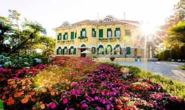
Bao Dai Palace 1
Da Lat is famous for 3 palaces during King Bao Dai's reign: Palace 1, Palace 2, Palace 3, associated with the ups and downs of our country's history. In 1940, a French millionaire named Robert Clément Bourgery built Palace 1. In 1949, King Bao Dai's father-in-law contributed money for the king to buy this mansion. King Bao Dai set up his General Headquarters here to work during his years as Head of State from 1949 to 1954. Besides Da Lat, King Bao Dai also owns another very famous mansion in Vung Tau, which is Bach Dinh. In 1956, Palace 1 was transferred to Ngo Dinh Diem for use. Many years later, this place became a resting place for heads of state until 1975. In 2014, the local government invested in restoring and repairing Palace 1, making this place available for sightseeing. vacation in Da Lat. Palace 1 of Da Lat (Bao Dai Palace) has undergone many renovations. The outside campus is spaciously designed and equipped with luxurious tables and chairs. Stepping through the gate into the campus, there are hundreds of blooming flowers, a giant flag garden, 7-color steps, hundreds of hanging lanterns... The fountain has a bold European feel as well. attracts many tourists. Stepping up to the first floor, in addition to the main lobby area, on both sides of the palace are 2 large living rooms, behind are 4 rooms of different sizes. In the past, these rooms were used as transition rooms, clerical rooms, kitchens and WCs. At the end of the first floor is a very majestic and magnificent photography room. Including a throne, a hammock painted in red and gold... When you step up to the 2nd floor of Bao Dai Palace 1, you will see 3 different bedrooms. The first room is the bedroom of King Bao Dai's mother (Mrs. Tu Cung). The second room is King Bao Dai's bedroom. Next is Queen Nam Phuong's bedroom, located opposite the palace hallway. It can be said that the second room is the most important in King Bao Dai's first palace. This is where important meetings took place during the reign of King Bao Dai from 1949 to 1954. This is also the place to discuss campaigns and wars from 1955 to 1963. During Ngo Dinh Diem's government, he renovated King Bao Dai's room and dug a secret tunnel here. The path down to the tunnel is disguised to look like a bookshelf to the right of the bed. This exit leads to the helipad behind the hill of palace 1. Especially in this mansion are military-style constructions, you will not help but be surprised and overwhelmed by its unique appearance. First is a large helicopter landing pad, gas depot, and emergency exit (tunnel). The tunnel door is equipped with metal weighing several hundred kilograms, artillery, bulletproof glass... Source: Da Lat tourism information portal
Lam Dong
8463 view
Rating : National monument

Relics of Resistance Base Area 6 Cat Tien
The historical relic site of resistance base in Cat Tien zone VI has a total area of nearly 50 hectares, located in village 5, Duc Pho commune, Cat Tien district, Lam Dong province. This is an ideal address to attract people and tourists who love nature, explore and learn about history and national revolutionary traditions. Area VI relic, Cat Tien is a work of important historical significance, recording the merits and achievements of generations of ancestors in the struggle against the American invaders, period 1963 - 1966. Mold The relic site of Area VI, Cat Tien is designed harmoniously, scientifically and beautifully, suitable for the landscape space, with a system of clean, beautiful concrete-paved internal roads winding around cool, green ponds and lakes; The majestic monument located on the top of the central hill has created a highlight that attracts the attention of people and tourists when visiting the relics of Area VI, Cat Tien. Not far from Monument Hill is a display house with 108 collected artifacts and a number of primitive weapons restored for display and explanation. Scattered on the green hillsides shaded by forest trees are buildings of camps and shelters recreating the working and living spaces of "Region and Military Region Party Committee agencies" with a total of 23 categories. categories, in which, the Regional Party Committee agency has 12 categories and the Military Region agency has 11 categories. According to historical documents, in the period from 1963 - 1966, Cat Tien Party Committee and Zone VI made important contributions marking the continuous growth of our country's revolutionary forces. In the beginning, Area VI was the place to focus on consolidating and preparing the necessary conditions to coordinate with the entire South to attack the enemy, destroy strategic hamlets, expand the controlled and liberated areas, and create position and force. for the Vietnamese revolutionary movement to win great victories. Especially in the Winter - Spring of 1964 - 1965, the revolutionary movement in Area VI had a leap forward in both width and depth; The army and people of Zone VI proactively coordinated with the entire South to attack the enemy in the Dong Xoai campaign in the summer of 1965, contributing to the bankruptcy of the US imperialism's "special war" strategy. In the dry season of 1965 - 1966, the army and people of Zone VI defeated the enemy's first counterattack in the Zone VI battlefield. From here, the army and people of Zone VI continuously failed the enemy's pacification and search-and-destroy plan in the second strategic dry season counterattack (1966 - 1967). By the dry season of 1967 - 1968, the army and people of the Zone VI stepped up its attacks and won great victories. From mid-1965 to the end of 1968, the Party Committee, army and people of Region VI coordinated with the entire region to defeat the "Local War" strategy of the US imperialists. The victories of the army and people of Zone VI - Cat Tien demonstrate the Party's ingenious and wise leadership. Among them, the ethnic community of Zone VI was united, heroic, and indomitable, achieving resounding victories, demonstrating the brilliance of revolutionary heroism, and with passionate patriotism helping the army. and the people of Area VI overcame countless difficulties and challenges, winning victory after victory in the resistance war against the US to save the country, contributing to completely liberating the South and reunifying the country. The construction and embellishment of the historical relics of the resistance base of Zone VI, Cat Tien has shown the spirit of drinking water, remembering the source, honoring and promoting the great historical values of the army and people of Zone VI, and the community. This is the place to educate, train and foster revolutionary traditions for future generations. Source: Cat Tien District Electronic Information Page
Lam Dong
11201 view
Rating : Special national monument
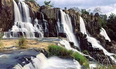
Datanla waterfall relic area
National historical and cultural relic tourist area Da tang la waterfall, also known as Da tan la, is a famous waterfall in Da Lat city, Lam Dong province, Vietnam. Located in the Da Tan La tourist area, the waterfall is 8 km from Prenn waterfall and about 10 km from Da Lat city center. Da Tang La Waterfall is considered one of the ideal destinations for tourists who want to visit and experience adventure. The name "Da tang la" or "Da tang la" is taken from the K'Ho language, made up of the word "Da-Tam-N'ha", meaning "there is water under the leaves". This name originates from the historical conflict between the Cham - Lach - Chil peoples in the 15th century. to the 17th century. Da Tang La Waterfall has abundant water thanks to a stable water source from upstream. Not as noisy as some other waterfalls, Da Tang La flows through many stone shelves and falls from rapids about 20m high. The lower part of the waterfall forms a very clear water area, called Suoi Tien, while the upper part has a deep pool called the Death Abyss. According to legend, because this abyss is located in the middle of a mountainous area, it was once a refuge for an army of the indigenous people during the war with the Cham people hundreds of years ago. There are many legends about the origin and meaning of Da Tang La waterfall. One of them tells about the meeting of the brave warrior K'Lang and the mountain girl Hobilang here. Some other legends about Da Tang La waterfall say that the waterfall is the place where fairies often bathe, or the story about the war between the Lat and Cham people, in which the waterfall played an important role in the fighting strategy of the people. Surname. With those cultural values, in 1998, Da Tang La Waterfall was recognized by our state as one of the famous landscapes and historical relics in Da Lat, ranked as a national monument. . Source: Da Lat tourism information portal
Lam Dong
5632 view
Rating : National monument
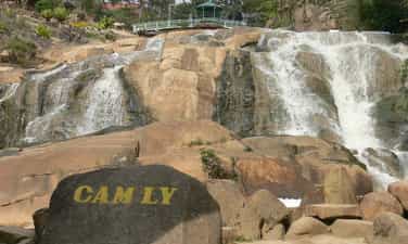
Historical relic of Cam Ly Waterfall in Dalat
Cam Ly Waterfall is located 2km west of Da Lat city. This is considered the waterfall located closest to the city center. Cam Ly waterfall is located next to Cam Le stream, the waterfall is formed from part of the water flowing in from Xuan Huong lake and another stream, Cam Ly stream, also flows here. Cam Ly Waterfall is one of the waterfalls that talks about the remembrance, gratitude, and respect of the people here for people with meritorious services during that period. Legend has it that Cam Ly waterfall originated from the K'Ho language. People in the Lach (Lat) tribe call Cam Ly waterfall Lieng To Sra - the boundary of Cam Le stream to Da Dong river. People in the new village took the name of the chief of the Lach (Lat) tribe at that time, K'Mly, to commemorate and show the villagers' gratitude to this chief. This chief took care of the meals and sleep of the entire tribe, lived in harmony with the people, and took care that the lives of the people in the village became prosperous, prosperous, and complete. So the name of this chief given to the waterfall was K'MLy, later pronounced Cam Ly. According to the Sino-Vietnamese origin, Cam Ly means stream with fresh water (Cam means sweet, Ly means permeable). Cam Ly Waterfall possesses poetic beauty, especially in the rainy season when the water flows rapidly, creating huge blocks of water pouring down violently. With a convenient location near the city center, Cam Ly waterfall attracts a large number of tourists every year. At the foot of Cam Ly waterfall is a small flower garden, contributing to creating a harmonious and beautiful landscape. In addition, in the waterfall area there is also Nguyen Huu Hao mausoleum, built with many unique architecture. In 1998, Cam Ly Waterfall was ranked by our state as a scenic spot and historical relic in Da Lat, recognized as a national monument. Source: Da Lat tourism information portal
Lam Dong
5607 view
Rating : National monument

Xuan Huong Lake Relics
When mentioning Da Lat, no one knows about Xuan Huong Lake, a beautiful lake located right in the center of Da Lat city. Xuan Huong Lake is an artificial lake, with a circumference of about 5km and 25ha wide. The lake has the shape of a crescent moon, stretching more than 2 km and passing through many famous tourist attractions of Da Lat such as the City Flower Garden, Yersin Park, Cu Hill and Lam Vien Square. According to people here, the origin of the name Ho Xuan Huong comes from two different legends. The first legend says that every spring, there is a faint, fragrant scent around the lake, ecstatic. That's why people gave the lake the name Xuan Huong Lake. However, the second legend says that Ho Xuan Huong was named after a 19th century Vietnamese female poet named Ho Xuan Huong. Ho Xuan Huong is the author of a number of famous poems such as Floating Water Cake, Life as a Monk, Debt to Husband and Children,... Xuan Huong Lake was originally a large valley, and Cam Ly stream flowed through. In 1919, engineer Labbe blocked this stream so that water could accumulate and form a lake. Then, in 1923, French engineers built a dam at the bottom of the lake, but it broke after a storm in 1932. Engineer Tran Dang Khoa then rebuilt a new dam. made of stone. In 1989, Xuan Huong Lake was recognized by our state as one of the famous landscapes and historical relics in Da Lat, ranked as a national monument. Source: Da Lat tourism information portal
Lam Dong
7673 view
Rating : National monument

Tuyen Lam Lake Relic in Da Lat
Tuyen Lam Lake was formed in 1985 - 1986. At that time, the People's Committee of Lam Dong province and Duc Trong district deployed troops to build dams to retain water in the Suoi Tia area. Surrounding the Suoi Tia flow area are surrounding mountain ranges that form a basin. When the dam is built to retain the water, it forms Tuyen Lam Lake as it is today. Initially, the main purpose of Tuyen Lam Lake was to store water for main use for irrigation in agricultural production in the downstream area - Hiep An and Dinh An communes in Duc Trong district of Lam Dong province. By 1998, when Tuyen Lam Lake was recognized by the Ministry of Culture, Sports and Tourism as a national historical and scenic site on August 31, 1998, the Tuyen Lam Lake area received even more attention and attention. Not only does it serve irrigation purposes in agricultural production, but it is also used by agencies from central to local levels to guide tourism development planning. Tuyen Lam Lake has an area of 350 hectares; More than 6km south of Da Lat city center. Tuyen Lam Lake area has a fresh climate, quiet space, natural landscapes (forests, mountains, lakes, streams, waterfalls,...) that are diverse, attractive and have many attractive and promising humanistic elements. become a large-scale tourist area with many unique types of tourism such as: sightseeing, camping, relaxation, medical treatment, walking, climbing, fishing, festivals - beliefs, entertainment entertainment, sports,...especially eco-tourism. During the two resistance wars against the French and American invaders, with the location and topography of the Suoi Tia area (now Tuyen Lam Lake) and Elephant Mountain, it was the most important base of the revolutionary movement in Da Lat city and Da Lat city. Tuyen Duc province. This base area serves as a place to direct political and armed struggle movements of the army and people of Da Lat town and Tuyen Duc province, and a place to gather and train the armed forces. , the working teams of the Province and the military region, are the springboard for forces to attack Da Lat and maneuver to fight the enemy on fronts in Tuyen Duc province. During the resistance war against the Americans, in addition to the City Party Committee, there were also military units stationed such as the Financial Department, the clinic, the Women's Work Team, the Youth and Students, the Urban Work Team, and the City Special Forces 850 and 852. , 860... and leading agencies and front units of the province such as the Provincial Party Committee, Provincial Team, logistics, Corridor Station, Company 810 (later to become Battalion 810), Provincial Security Team and forces of the Region 6 as Battalions 186, 145, 200C. From 1982 to 1987, Lam Dong Irrigation Company, invested by the Ministry of Irrigation, built a 235m long dam across Tia stream to create Quang Trung lake, later renamed Tuyen Lam lake. By 2017, the Prime Minister recognized Tuyen Lam Lake National Tourist Area, Da Lat City, Lam Dong Province as a National Tourist Area. Tuyen Lam Lake National Tourist Area was honored by UNESCO as "Typical Asia-Pacific Tourist Area" in the Forum Program "Vietnam - India Cultural and Economic Exchange". Tuyen Lam Lake National Tourist Area has rich tourism resources including natural landscapes, forest resources, climate, cultural and architectural values; Invested and renovated infrastructure along with ongoing investment projects have been promoting value, contributing to affirming the position of Tuyen Lam Lake National Tourist Area on Vietnam's tourism map. South with diverse types of tourism. Source: Management Board of Tuyen Lam Lake National Tourist Area
Lam Dong
5858 view
Rating : National monument
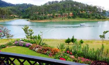
Historical site in Da Lat - Than Tho Lake
Than Tho Lake is located about 6 km east of Da Lat city center, near Da Lat National Martial Arts School (currently the Army Academy). The lake is located on a high hill in the middle of a pine forest, providing a peaceful and quiet space. On the north side of the lake there is a pair of pine trees that evoke the image of a couple, near the scenic Pine Hill Two Tombs with the legend of a broken love. Initially, the Than Tho lake area was just a small pond, and was called Tono Pang Dong. However, in 1917, the French built a lake here to provide daily water for Da Lat. The French named the lake Lac Des Soupirs (meaning "murmuring lake" in French). However, later, the lake was renamed Than Tho Lake by Mr. Nguyen Vy, Chairman of Da Lat Town Council, to express sympathy for the legend of the romantic love story between Hoang Tung and Mai relying on the year of the 18th century here. Than Tho Lake has experienced many ups and downs in history. From the reclamation of mountains and forests in the 1980s - 1990s, to the process of conservation and restoration at the end of 1990. In 1999, Than Tho Lake was recognized and ranked by our state as a scenic spot, national historical relics. Source: Da Lat tourism information portal
Lam Dong
5688 view
Rating : National monument
Outstanding monuments
See all
Lang Le Bau Co relic site
Lang Le Bau Co relic site is located in Tan Nhut commune, Binh Chanh district, Ho Chi Minh City. Lang Le Bau Co is associated with the resistance war against the French invasion in 1948 with major battles that went down in history. Lang Le Bau Co relic was recognized as a city-level historical relic in 2003. The reason it is called Lang Le Bau Co relic area is because the name of Lang Le Bau Co relic area was given by local people. The hamlet was established next to the interlaced canals and rivers. Lang Le Bau Co is located inside a large field with many shrimp, crabs, and fish. Along with many species of birds such as mallards, storks, teal, nuthatches, gongs, partridges, herons, and red armpits come to feed here. Therefore, Tan Nhut people call it by the familiar and rustic name Lang Le Bau Co. Lang Le Bau Co relic is considered the gateway to move to the center of Vuon Thom base and attack the enemy headquarters in Saigon. Previously, Lang Le Bau Co relic area was originally a field of overgrown reeds. On April 15, 1948, the French colonialists sent 3 thousand soldiers and many modern weapons to simultaneously attack the Lang Le Bau Co area to destroy the Vuon Thom base. At that time, the revolutionary armed forces in Lang Le - Bau, because of their small force and rudimentary weapons, had the help of local people along with the advantage of terrain. After just over half a day of fighting, it turned to attack, causing the French army to suffer a large number of casualties. The victory at Lang Le Bau Co killed 300 enemies, captured 30 mercenaries, and destroyed many machines, military vehicles, and guns of all kinds of the enemy. However, on our side, there are many officers and soldiers who heroically sacrificed their lives at a very young age. On October 14, 1966, in Lang Le, the Republic of Vietnam Army Ranger Battalion was destroyed by tourist militia. Lang Le Bau Co relic site has great historical significance for the people of Saigon in particular and the whole country in general. Faced with hatred for the French colonialists, Lang Le Bau Co's army and people fought a war of great historical significance that opened the door for our side and the enemy. For our side, the battle opened the door to heroism in a strong resistance position. As for the enemy, they had to retreat into a strategic position and were destroyed. The French colonialists could no longer form a strategy to defeat the Viet Minh. Moreover, at Vuon Thom base, Lang Le Bau Co also took place a determined battle to protect our base and destroy all sabotage plans of the enemy. Lang Le Bau Co relic area, after the Dong Khoi movement in 1960, was also a logistics and springboard for the armed forces to liberate Long An - Saigon - Gia Dinh. To commemorate the sacrifices of our compatriots and soldiers, in 1988 Binh Chanh district built a historical building in Lang Le Bau Co land with an area of 1000m2. Source: Ho Chi Minh City Electronic Information Newspaper
Ho Chi Minh City
18072 view
Rating : City-level relics

Tan Hiep Prison Historical Relic
Tan Hiep Prison, also known as "Tan Hiep Correctional Center", is located in Quarter 6, Tan Tien Ward, Bien Hoa City. Tan Hiep Prison Relic was ranked as a national relic by the Ministry of Culture and Sports on January 15, 1994. Tan Hiep Prison is one of the six largest prisons in South Vietnam and the largest prison in the Southeast region, built in an important military position, northeast of Bien Hoa town. Ahead is National Highway 1; Behind is the North - South railway line. This is an isolated location, convenient for transportation, easy for protecting, guarding, receiving prisoners from other places and transferring prisoners to Con Dao, Phu Quoc... Tan Hiep Prison has an area of 46,520 square meters with 8 prisons, including 5 prisons for communist prisoners and patriots. The prison is surrounded by 4 layers of barbed wire with 9 bunkers, 3 watchtowers with a team of guards and a modern alarm system. It's called "Correctional Center" but inside is actually a gun warehouse, an interrogation and torture room with the most modern tools. Each prison only has an area of nearly 200 square meters but holds 300-400 people, sometimes up to a thousand people. In particular, there are "repentance" rooms and "tiger cages" that are very small and narrow and living conditions are extremely harsh, prisoners live like in a crematorium. The diet was extremely unhygienic. The prison guards bought rotten rice and rotten fish to fertilize the fields, and fried them in oil to feed the prisoners, leading to many people being poisoned. With the determination to escape the imperial prison, return to the Party and the people to continue fighting and liberating the nation, on December 2, 1956, with the agreement of the Eastern Inter-Provincial Party Committee, the soldiers Communists were "detained" in Tan Hiep prison under the direct direction of comrade Nguyen Trong Tam (Bat Tam) - in charge of the prison Party Committee and a number of other comrades who suddenly broke the shackles. was able to free nearly 500 comrades and patriots. This event caused a stir in the Pentagon. America - Diem hastily mobilized both main forces and security forces, civil guards defending the three provinces of Bien Hoa, Ba Ria, Thu Dau Mot and two special forces to encircle and capture the prisoners, but all were defeated. failure. Our comrades and compatriots who escaped from Tan Hiep prison received help and protection from local facilities and returned safely to base. Among the escaped prisoners were comrades: Bay Tam, Hai Thong, Ly Van Sam... who became the core nucleus of the Dong Khoi movement later. In 2001, to partly recreate the crimes of the US - Diem against our comrades and compatriots imprisoned at Tan Hiep prison and describe the entire Tan Hiep uprising on December 2, 1956. , Dong Nai Museum has collected images, documents, and artifacts displayed at the relic and made a model to serve the research and sightseeing needs of all classes of people. Every day, the monument is open to visitors. Source: Dong Nai Electronic Newspaper
Dong Nai
16553 view
Rating : National monument

Nguyen Huu Canh Temple
Nguyen Huu Canh temple, also known as Binh Kinh communal house, is located on the left bank of Dong Nai river, formerly belonging to Binh Kinh hamlet, Binh Hoanh village, Tran Bien canton, now Nhi Hoa hamlet, Hiep Hoa commune, Bien Hoa city. It was ranked as a national historical relic by the Ministry of Culture, Information, Sports and Tourism on March 25, 1991. Nguyen Huu Canh Temple was built around the end of the 18th century. Initially, the temple was small in scale, with walls made of boards and a yin-yang tile roof, about 400m south of the current temple. Documents say: the temple was first rebuilt in the fourth year of Tu Duc (1851); By 1923, the temple was rebuilt at its current location. Nguyen Huu Canh was born in 1650 in Gia Mieu, Tong Son district, Thanh Hoa province in a family with many famous generals in the dynasty. He was a man of both literature and martial arts, accomplished many great victories and was trusted, loved and respected by Lord Nguyen. In the spring of the year Mau Dan (1698), he obeyed Lord Nguyen's order to invade Dang Trong while it was still very desolate. Arriving in Dong Nai, he set up his headquarters at Cu Lao Pho (now Hiep Hoa commune); took Dong Nai land as Phuoc Long district, built Tran Bien palace, took Saigon land as Tan Binh district, built Phien Tran palace, the land expanded thousands of miles. He recruited immigrants to settle down, organized the administrative apparatus gradually and systematically, encouraged land reclamation, and promoted Cu Lao Pho to develop into one of the busiest and most dynamic port towns throughout the century. 18 and officially annexed the new land of the South into the Dai Viet map. After returning from the invasion of the South, the following year he again served Lord Nguyen Phuc Chu's command to lead an army to suppress King Chan Lap and maintain the southern border region. In April of the year Canh Thin (1700), after completing his mission, on the way back to Rach Gam (Tien Giang), he fell ill and passed away on the 16th day of the 5th lunar month, at the age of 51 years old. On the way to his hometown for burial, his coffin was stopped at the land where he once had his headquarters on Cu Lao Pho so that local people could have the opportunity to say goodbye to him one last time. At the mandarin's communal house, local people built a tomb to remember this event. When hearing the news of Nguyen Huu Canh's death, Lord Nguyen was extremely sorry and conferred on him the title of High-ranking official of the Town Chancellor with the title: Thanh Marquis Ceremony and had his tablet enshrined at the Thai temple. Source: Dong Nai Electronic Newspaper
Dong Nai
15156 view
Rating : National monument

La Nga victory relic
La Nga Victory Relic (at km 104-112 on Highway 20 to Da Lat, in Phu Ngoc commune, Dinh Quan district) was ranked a national historical relic by the Ministry of Culture on December 12, 1986. To cheer for the Viet Bac victory in the fall-winter of 1947 and also to deal a fatal blow to the enemy, the command board of squad 10 decided to organize a big battle, to show the enemy that the Vietnamese people were , Vietnamese people do not easily submit to any enemy; With a spirit of courage and ingenuity after nearly half a year of preparation, studying the terrain, and choosing a location: at 15:12 on March 1, 1948, the La Nga ambush battle began and ended at 15:12 on March 1, 1948. 15:57 on the same day, in just 45 minutes. The victory of La Nga delighted the people of Dinh Quan in particular and the people of Dong Nai in general. This is a victory that demonstrates the cunning and courage of our army and people, causing the enemy to be stunned and defeated. From this victory, our force grew stronger and stronger, contributing to defeating the enemy's plan to attack quickly and win quickly, forcing them into a passive position. The scenic complex of Chong Rock, Mai Waterfall, La Nga River and La Nga Victory Monument is an interesting tourist complex of Dinh Quan. The amazing beauty of Hon Ba Chong, Da Voi Mountain, Hon Dia, along with the natural pagoda at the foot of the rocky mountain are typical clusters that create a harmonious beauty for the Da Chong scenic area. Dinh Quan Da Chong Complex is also a place that retains traces of prehistoric life. Here, under the stone roofs, along the streams and on the slopes along the valley, many production and daily life tools of the ancients made of stone, bronze and terracotta were discovered. During the 30-year resistance war. Dinh Quan is an important part of War Zone D. Da Chong witnessed the formation, development, stationing, and combat deployment of revolutionary forces. Today, a part of the land of Da Chong Dinh Quan scenic area has been used and built into the Dinh Quan District Cultural and Sports Center. In the near future, Da Chong Dinh Quan scenic area will be invested in and renovated, contributing to making the natural landscape more beautiful and becoming an attractive eco-tourism destination. Source: Dinh Quan District People's Committee
Dong Nai
14989 view
Rating : National monument

Chot Mat ancient tower
Chot Mat Tower Historical-Cultural Relic, located in Xom Thap hamlet, Tan Phong commune, Tan Bien district, Tay Ninh province, was recognized by the Ministry of Culture and Information (now the Ministry of Culture, Sports and Tourism) as historical - cultural relic on July 23, 1993. Also one of the last three ancient towers remaining in the South of our country. Having undergone many restorations in 1938, 2003 and most recently in 2013. Despite undergoing restorations, the Chot Mat ancient tower relic site has given itself a new look but still remains retains the spirit of ancient architecture. The entire Tower is built of brick and slate with the top of the tower tapering upward, from the ground to the highest point of the tower is estimated to be 10m. In addition, this ancient tower is located on a high mound in the middle of the field, so from a distance it looks like a pen rising gradually. In 2003, the People's Committee of Tay Ninh province decided to approve the investment project to restore, embellish and preserve Chot Mat tower relics and carried out the restoration, restoration, display and opening of the excavation pit in 2003. into use. On November 27, 2019, the Provincial People's Committee issued a Decision regulating the decentralization of management, protection and promotion of the value of historical and cultural relics and scenic spots in Tay Ninh province. Decision to assign the People's Committee of Tan Bien district to directly manage 4 relics, including the National Historical-Cultural relic Thap Chot Mat. In particular, the Chot Mat Tower Historical-Cultural Relic in Tan Phong commune, Tan Bien district was chosen to be part of the tourism development link of Tay Ninh Province. This is a tourist destination worth exploring, contributing to tourism development in Tan Phong commune in particular and Tan Bien district in general. Source: Tay Ninh province electronic information portal
Tay Ninh
14838 view
Rating : National monument

Hoc Mon District Palace
Hoc Mon District Palace is located at No. 1, Ly Nam De Street, Hoc Mon Town, (next to the District People's Committee headquarters) and is the place where many outstanding fighting events have been recorded throughout the long history from 1885 to the Southern days. Complete liberation of the People of 18 Betel Garden Villages. After defeating Chi Hoa Fort, the French colonialists built a 3-storey wooden house here to use as a military post. When Tran Tu Ca took office as Governor of the Palace, he used the Station as the Palace of Binh Long district. Originally a cunning drunkard of the French colonialists, Tran Tu Ca was led by a group led by Mr. Phan Van Hon (Quan Hon) and Nguyen Van Qua (Chanh Lanh Binh) of nearly 1,000 insurgents who came to burn the District Palace, captured and head cut off in the middle of the market. That was February 8, 1885, At Dau Tet. Afterwards, Hoc Mon District Palace was rebuilt with a blue stone foundation, brick walls, and a defense system from the upper floors to the fence. The architecture is similar to the Military Fort, so the locals call it Hoc Mon Fort. Tran took over from Tran Tu Ca as Governor of Ngon district, moving to Tra District and then Tho District. This was a long period of time when the people of the Hoc Mon region suffered from many cruel and despicable scenes from the French colonialists and their oligarchic henchmen mentioned above. With the indomitable tradition of Hoc Mon people. On June 4, 1930, around 6 a.m. in front of the District Palace, hundreds of Hoc Mon people protested demanding "abolition of poll tax, reduction of license and market taxes, and granting land to poor farmers." Tra District invited the leaders into the Palace to negotiate, but they cunningly arrested them, including Mr. Le Van Uoi (Secretary of Tan Thoi Nhi Commune), who was the leader of the protest. People were undaunted and fiercely demanded that Tea District release those detained. The protest group became more and more crowded, the fighting spirit spread somewhat, causing Tra District to give in. On the one hand, they released the detained people, on the other hand, they called the officials in Saigon for help. 2 hours later, the struggle was led by two men, Blachole and Nobbot, who opened fire on the protest group, causing many casualties. But the most impressive historical event at Hoc Mon District Palace was the Southern Uprising on November 23, 1940. Hoc Mon Fort is very solid, built of green stone like a fortress, about 15 meters high, has a gun emplacement and a defense system with battlements guarded by a platoon of green soldiers. On November 22, 1940, France reinforced one more platoon to deal with the situation. On the afternoon of November 22, 1940, Mr. Do Van Coi's army broke into the town, disguised as civilians, ambushed behind the Station waiting for orders to rob the Station. Another army wing has the task of destroying bridges, cutting down trees blocking roads, and occupying offices and houses... The army wing from Phuoc Vinh An, Tan Thong, Tan An Hoi, Tan Phu Trung is led by Mr. Pham Van Sang and Dang Cong Binh commanded, started from Ben Do hamlet, attacked the house, killed 1 person, collected 4 guns, and took control of the situation here (Tan Phu Trung). Immediately this army was ordered to pull back to Hoc Mon. The Long Tuy Thuong army was commanded by Mr. Bui Van Hoat. The army of General Long Tuy Trung was commanded by Mr. Do Van Day and Le Binh Dang. At around 24:00 on the night of November 22, 1940, the sound of artillery fire had not yet been heard in Saigon. After consulting, the army commanders united to attack the enemy's post. Immediately the troops headed straight to Fort Hoc Mon, where District Chief Bui Ngoc Tho resided. Two insurgents named Nghe and Kinh volunteered to enter the front gate and sacrificed their lives. Insurgents from all directions rushed into the Fort like water bursting its banks. Faced with the power of the insurgents and the masses, the soldiers in the Station no longer had the spirit to resist and fled in disarray. The insurgents completely occupied the inside of the station, but upstairs, the enemy still stubbornly used guns to shoot sporadically, at the same time calling Saigon and Thu Dau Mot for emergency help. Because he was eager to capture the name of Tho District, comrade Do Van Day climbed up to the upper floor of the Station by clinging to the gutter. Halfway up, he was hit by bullets, the comrade fell and died later. The battle was at a standstill when enemy reinforcements arrived. Unable to hold out, the insurgents withdrew from the town, dispersed to the villages, the armed forces withdrew to Ben Do hamlet (Tan Phu Trung) and then moved to My Hanh hamlet (Duc Hoa). Although the attack on Hoc Mon Fort (later called Hoc Mon District Palace) failed, it left a deep impression in the hearts of all civilians admiring the courage of revolutionary soldiers in the fight against colonialism. steal the country. During the historic Ho Chi Minh campaign, at 7:00 a.m. on April 30, 1975, Hoc Mon town was completely liberated, the National flag fluttered above the District Palace, where District Chief Nguyen Nhu Sang and his gang sai has been running away since last night. Today, Hoc Mon District Palace is chosen as the District Museum, where many documents are displayed, illustrating the ups and downs of historical periods as well as the revolutionary fighting spirit of the army and people in Hoc Mon district over the past two years. resistance war against French colonialism and American imperialism. A monument placed in front of the Hoc Mon District Palace relic represents the indomitable sacrifice of the army and people of 18 Betel Garden Villages, recognized as a national historical and cultural relic. Source: Hoc Mon District People's Committee
Ho Chi Minh City
14161 view
Rating : National monument

US Embassy building
The US Embassy relics, also known as the "White House of the East", are the origin of sinister military and political plots aimed at long-term annexation of Vietnam. The relic site is a 5-storey building built Built in modern architecture, located at the corner of Mac Dinh Chi - Le Duan Street, Ben Nghe Ward, District 1, Ho Chi Minh City, on a plot of land nearly 5,000 square meters. Previously, the US embassy was located at 39 Ham Nghi Street. At around 10:00 a.m. on March 30, 1963, the US embassy on Ham Nghi Street was hit with explosives by the F21 Commando team, collapsing three floors: 1, 2, 3, so the US decided to rebuild it. Construction began on the building in 1965, most of the materials and construction machinery were transported from the US, under the control of American engineers. According to the design, the building is surrounded by 7,800 Taredo stones that can withstand mines and artillery shells. The main door is equipped with thick steel, the other doors are blocked by a special thick bulletproof layer. All doors use automatic systems, including iron doors blocking the way to the upper floors. Inside the building there are 140 rooms with 200 staff serving day and night. In addition, next to the building is also built an additional row of houses called the "Norodom" area exclusively for C.I.A. employees. When inaugurated, the building had only 3 floors. At the end of 1966, two more floors and a terrace were built to serve as a landing place for helicopters. Surrounding the building is a 3m high wall, at both ends of the wall close to Le Duan Street, 2 high blockhouses are built, guarded day and night. The Embassy was completed in September 1967 with a defense system such as a fortress with 60 guards, a bomb shelter, and a radar screen system to control the facade. Immediately after the building was completed, on September 24, 1967, thousands of students flocked to the gate of the US Embassy to fight for "America to stop bombing the North", "America to go home" and issued a notice denouncing the US for "trampling and seriously violating the right to self-determination of the Southern people". But the outstanding event that happened at the US Embassy was the battle of the City Rangers during the General Offensive and Uprising in the Spring of 1968. The target of attacking the US Embassy was added on January 24, 1968 by Ngo Thanh. Van is in charge of general affairs. Ranger Team 11 took on this important mission, including captain Ut Nho (military region reconnaissance captain) and soldiers: Bay Truyen, Tuoc, Thanh, Chuc, Tran The Ninh, Chinh, Tai, Van, Duc, Cao Hoai Vinh, Mang, Sau and 2 drivers: Tran Si Hung and Ngo Van Thuan. Another equally humiliating event for the US Embassy was the chaotic escape that occurred on April 29 and 30, 1975 by the US and its accomplices. Faced with the rapid attack of the Vietnamese army and people in the historic Ho Chi Minh campaign, over 1,000 Americans and more than 5,000 pro-American Vietnamese jostled, pushed, and kicked each other to compete for a place on the terrace of the building. building to be rescued by helicopter. This relic was granted a certificate of recognition by the Ministry of Culture on June 25, 1976. Currently, the US Embassy building has been demolished and a new consulate in Ho Chi Minh City has been built, but next to it is a memorial stele forever remembering the achievements of the special forces soldiers who died in the battle. . Source: Ho Chi Minh City Youth Union
Ho Chi Minh City
14062 view
Rating : National monument

Tomb of Mai Xuan Thuong
Mai Xuan Thuong was the leader of the Can Vuong movement against the French at the end of the 19th century in Binh Dinh. Mai Xuan Thuong was born in the year of Canh Than, 1860, died in the year of the Pig, 1887, from Phu Lac village, Phu Phong district, Tuy Vien district, Binh Dinh province (now Phu Lac village, Binh Thanh commune, Tay Son district, Binh Dinh province). His father, Mai Xuan Tin, was the chief father in Cao Bang. His mother, Huynh Thi Nguyet, was the daughter of a noble family in the village. Mai Xuan Thuong is inherently intelligent and eager to learn. At the age of 18 (1878), he passed the Baccalaureate at Binh Dinh Examination School. At the age of 25 (1885), he passed the bachelor's exam. Responding to King Ham Nghi's Can Vuong edict, Mai Xuan Thuong returned to his hometown of Phu Lac, recruited insurgents, set up a base on Sung island to raise the Can Vuong flag against the French, then Mai Xuan Thuong brought his forces to join the army. The insurgent army was led by Dao Doan Dich and was appointed by Dao Doan Dich to the position of Military Salary Officer (in charge of food for the insurgent army). From then until 1887, the Can Vuong movement in Binh Dinh developed strongly and spread to Quang Ngai, Phu Yen... attracting tens of thousands of people from all walks of life to participate. On September 20, 1885, Dao Doan Dich died and assigned all his forces to Mai Xuan Thuong. He chose the Loc Dong mountain area (now in Binh Tuong commune, Tay Son district) as his headquarters and organized a flag worshiping ceremony, calling on scholars, literati, and people to join the movement to fight against the French. During that ceremony, insurgents from many regions in Binh Dinh province agreed to honor him as the Marshal leading the uprising and raised the slogan: "First to kill the left, later to attack the West". In early 1887, the French army under the command of Lieutenant Colonel Cherrean and the royal army led by Tran Ba Loc along with Minister Trira launched a major attack on the headquarters of the Can Vuong movement in Binh Dinh, the battle The fighting between the insurgent forces and the French enemy was extremely fierce, the fight was unequal, and in the end the insurgent force was pushed back. In March 1887, after a fierce battle in Bau Sau (An Nhon town, Binh Dinh province), Mai Xuan Thuong was seriously injured, the insurgents withdrew to Linh Dong secret area. On April 21, 1887, Tran Ba Loc surrounded and captured the Linh Dong secret base and captured a number of insurgents, including Mai Nguyen Soai's mother. On the night of April 30, 1887, Mai Xuan Thuong sent a suicide squad to break into Tran Ba Loc barracks, relieve the captured people, and he and a group of 50 subordinates crossed the mountain into Phu Yen and continued to resist. battle, but when she reached Phu Quy Pass (boundary between Binh Dinh and Phu Yen), she was captured by Tran Ba Loc's ambush and taken to be beheaded at Go Cham (East of Binh Dinh Citadel). The mausoleum of patriot Mai Xuan Thuong is located on a high hill of the Ngang mountain range (in Hoa Son village, Binh Tuong commune, Tay Son district, Binh Dinh province) about 50km northwest of Quy Nhon city; The mausoleum was built on a land area of 1988m2, inaugurated on January 22, 1961. Overall, the mausoleum is designed in the style of an ancient mausoleum, surrounded by low walls. The Lang gate (three gates) is made up of 4 square pillars, the top is tied in the style of a gourd and a vase, bearing the architectural appearance of a communal house or temple gate of the late 19th century. In the middle of the Mausoleum is Mai Xuan Thuong's tomb, rectangular in shape in the East - West direction; At the head of the grave is a stone stele engraved with an inscription recording the biography and career of Mai Xuan Thuong: The relic was ranked at the National level by the Ministry of Culture and Information on April 20, 1995. Source: People's Committee of Tay Son District, Binh Dinh Province
Gia Lai
13753 view
Rating : National monument

Mac Dynasty Citadel in Cao Bang (Na Lu Citadel, Ban Phu Citadel, Phuc Hoa Citadel)
During the period when the Mac dynasty had its capital in Cao Bang, in order to prevent the Le dynasty from attacking, the Mac dynasty restored and repaired Na Lu citadel (now in Hoang Tung commune, Hoa An) and Ban Phu citadel (now in Hung Dao commune). ), Phuc Hoa citadel, in addition to building many other citadels in Cao Bang, making Cao Bang a political and military center in the far Northeast border region at that time. Na Lu citadel and Phuc Hoa citadel are two citadels built before. According to the records of Be Huu Cung in Cao Bang Thuc Luc, Na Lu citadel and Phuc Hoa citadel began in the reign of Tang Y Tong in the year Giap Than, the 5th Ham Thong era (874). Based on the presence of many ancient tombs with stone inscriptions containing the names, addresses, and hometowns of the citadel builders who died here during the Ham Thong Dynasty, it can be confirmed that these two citadels were built during the Tang Dynasty. Na Lu Citadel was built over many different dynasties. When the Mac dynasty came to Cao Bang, it was rebuilt with bricks. Na Lu citadel has a nearly rectangular shape, has a total area of about 37.5 hectares, a length of about 800 m, a width of about 600 m, the citadel has 4 gates. Ban Phu citadel in the capital of Nam Binh, Nam Cuong country of Thuc Phan in the past in Cao Binh (Cao Bang), the Mac dynasty renovated the royal palace in the inner circle of the old capital of Nam Binh and called it Ban Phu citadel or Royal Palace. In the ancient capital of Nam Binh of the Nam Cuong country and the Mac dynasty, Ban Phu citadel still has clear traces. The capital city of Nam Binh consists of two citadels, to protect the citadel, the outer ring has a circumference of about 5 km, including a low hillock area, around the foot of the hill is covered with vertical canvas like a wall, convenient for navigation. Build defense lines. The western wall of the citadel runs parallel to the bank of the Bang River to the beginning of Bo Ma village, connecting the southeast wall of the citadel, flowing in front of Ban Phu, following the foot of the hill to meet National Highway 4, the northeastern side running along the foot of the hill close to the outside of National Highway 4. , up to the top of the mound is the northwest side, continue running along the foot of the hill, out to the river bank and meet the west wall, forming a closed citadel. When the Mac Dynasty established the capital, it repaired and built a number of additional works, in which Ban Phu Citadel (inner citadel - the king's working place) was built higher on the old citadel walls from the Thuc Phan period. The citadel is located on a flat land. Along with rebuilding the capital, the Mac dynasty also built a system of posts and ramparts quite thick around the capital and a number of important border points, forming a system of protecting the capital and protecting the border. gender. Phuc Hoa citadel (Phuc Hoa district) was built in a square style, about 400 m in each direction, including two citadel rings, the distance between the two rings is 80 m. Currently, the southern wall has been completely destroyed. Phuc Hoa Citadel has 2 main gates: The North Gate is open to the national highway to Ta Lung Border Gate today, people often call it Pac Gate, this gate is built in a rectangular style, 8 m wide, 5 m high. , including two gates made of thick, very sturdy wood; The second gate is in the south, opening to the river bank. Both gates were flattened long ago, and now there are no traces left. Near the citadel, in the northwest suburbs along the riverbank, there are many traces of brick kilns. People said that during the process of labor and exploration, many intact brick kilns were found in this area. Through research and surveys, it has been shown that in Cao Bang, the Mac dynasty renovated, embellished and built many citadels and fortresses, including repairing, embellishing and rebuilding Ban Phu citadel, Na Lu citadel, and Phuc citadel. Hoa. These fortifications have formed a quite solid system of protecting the capital. Up to now, of the ancient citadels built by the Mac Dynasty during the capital period in Cao Bang, some of the citadels built of earth only have traces left, but the citadels built of stone are still very clear. Source: Cao Bang Electronic Newspaper
Cao Bang
13405 view
Rating : National monument

WARRIORS' MEMORIAL AREA AT THREE GIONG FORCES, NATIONAL HISTORICAL MONITOR
Nga Ba Giong relic is a revolutionary historical relic located in Hamlet 5, Xuan Thoi Thuong commune, Hoc Mon district. Surrounded by three roads: Phan Van Hon, Nguyen Van Bua and Provincial Road 19. Nga Ba Giong relic site is a memorial site for historical events in two wars against foreign invaders. Recognized as a national historical site in 2002. Giong Junction (also fully known as Giong Bang Lang Junction) is located in Xuan Thoi Tay village, part of 18 old betel garden villages formed from 1698 to 1731. For a long time, Giong Junction is a place with a folk name that has entered the history of the hometown of 18 betel garden villages of Hoc Mon - Ba Diem. Legend has it that in the past, this place was a relatively high land and a place where many linden trees grew, so this place got its name from there. After the Southern Uprising (November 23, 1940) failed, the French colonialists increased their repression and fierce terror against the revolutionary movement in the Hoc Mon - Ba Diem region. They set up three shooting ranges in Hoc Mon to kill Party leaders and patriotic comrades from their hometown of Hoc Mon and surrounding areas. Giong intersection is the third shooting range to record the heinous crimes of the French enemy and his henchmen against the people of Hoc Mon. Learning from the experience of 2 previous shooting ranges (1 at the old theater in the center of Hoc Mon District, 1 next to the well behind Hoc Mon Hospital today), they executed public shootings, forcing people to come and watch for the purpose of intimidation. revolutionary spirit of Hoc Mon people. But that firing squad backfired. The Hoc Mon people witnessed with their own eyes the cruelty of the French colonialists and the noble sacrifices of the communist soldiers, so their patriotic fire flared up even more fiercely. . For this third shooting range, they did not dare to build it near the center of the District anymore, but moved it to the Giong Junction area as a desolate, sparsely populated area to avoid people's resistance. Here, they built a shooting range with a solid mound of land 12m long, 2.2m high, in front of which were planted 6 shooting posts, each 1.7m high, the shooting direction facing the field (Ba Tram Lac). In 1941, here they secretly executed many times without letting the people see, hundreds of communist soldiers and patriots were killed by them. With the extremely sacred historical significance of Giong Junction, the place that marked the barbaric crimes of the French invaders, the place that demonstrated the indomitable fighting will and noble sacrifices of our comrades and compatriots later on. the Southern Uprising (November 23, 1940); After the complete liberation of the South (April 30, 1975), Hoc Mon district quickly restored and embellished the Nga Giong Junction revolutionary historical relic site to educate traditional generations of youth. This place has become a tourist attraction and a place to organize traditional festivals during major annual holidays of Hoc Mon district and the city, especially the anniversary of Southern Uprising Day (November 23). Currently, with the consent of the city, the district is renovating and building Giong Junction into "Giong Junction Martyrs' Memorial Area". Source: Hoc Mon electronic information portal
Ho Chi Minh City
13261 view
Rating : National monument